

Goeblange
Encyclopedia
Communes of Luxembourg
The communes of Luxembourg are the lowest nation-wide administrative division in Luxembourg. They conform to LAU level 2.Within the hierarchy of administrative subdivisions, communes come directly below cantons, which are directly below districts. Communes are often re-arranged, being merged or...
of Koerich
Koerich
Koerich is a commune and village in western Luxembourg. It is part of the canton of Capellen, which is part of the district of Luxembourg., the commune of Koerich has a population of 2,075. The other small communities in the commune are Goeblange, Goetzingen and Windhof...
, in southern Luxembourg
Luxembourg
Luxembourg , officially the Grand Duchy of Luxembourg , is a landlocked country in western Europe, bordered by Belgium, France, and Germany. It has two principal regions: the Oesling in the North as part of the Ardennes massif, and the Gutland in the south...
about 13 km west of Luxembourg City. , the village has a population of 425.
Location
Goeblange lies 321 m above sea level on the CR 109 from KoerichKoerich
Koerich is a commune and village in western Luxembourg. It is part of the canton of Capellen, which is part of the district of Luxembourg., the commune of Koerich has a population of 2,075. The other small communities in the commune are Goeblange, Goetzingen and Windhof...
to Capellen
Capellen
Capellen is a town in the commune of Mamer, in south-western Luxembourg, 12 km west of Luxembourg City. , the town has a population of 1,336...
at the crossroads with the road from Septfontaines
Septfontaines
Septfontaines is a commune and small town in western Luxembourg. It is part of the canton of Capellen, which is part of the district of Luxembourg. , the town of Septfontaines, which lies in the centre of the commune, has a population of 356...
to Windhof
Windhof
Windhof is a village in the south of the commune of Koerich in south-western Luxembourg. It lies on the N6 road from Luxembourg City to Arlon in Belgium...
. Once a farming community, it is now increasingly becoming a residential area adjacent to Koerich.
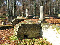
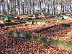
Gallo-Roman ruins
In the Miecher forest, about 1 km north-east of the village, extensive remains of a Roman farming communityRoman agriculture
Agriculture in ancient Rome was not only a necessity, but was idealized among the social elite as a way of life. Cicero considered farming the best of all Roman occupations...
have been found. Two large villas
Roman villa
A Roman villa is a villa that was built or lived in during the Roman republic and the Roman Empire. A villa was originally a Roman country house built for the upper class...
have been excavated and the foundations partially rebuilt. There are other buildings and fortifications on the site which are now being unearthed.
Information boards at the site explain that the villas probably date back to the 1st century but were extensively developed in the 4th century. Roman civilization was then thriving in the area owing to the prosperity of the imperial city of Trier
Trier
Trier, historically called in English Treves is a city in Germany on the banks of the Moselle. It is the oldest city in Germany, founded in or before 16 BC....
.
The Villa Miecher, a villa rustica covering some 700 m2 and designated Building I, stands on elevated ground overlooking the land to the south. The cellar built in the 1st century was later converted into a cistern for water supply. There is also evidence of water purification systems. By the 4th century, the south facade with its large porch, its two lateral towers and its central door must have made the villa an impressive sight.
The second building, in the north-west corner of the settlement was constructed in the 1st century but was considerably modified during the 2nd and 3rd centuries. The room in the north-west corner was converted into a caldarium for heated baths
Thermae
In ancient Rome, thermae and balnea were facilities for bathing...
. The other rooms were probably used to house the servants. The building was abandoned in the 4th century and fell to ruin.
The Roman road
Roman road
The Roman roads were a vital part of the development of the Roman state, from about 500 BC through the expansion during the Roman Republic and the Roman Empire. Roman roads enabled the Romans to move armies and trade goods and to communicate. The Roman road system spanned more than 400,000 km...
from Trier to Arlon and Reims
Reims
Reims , a city in the Champagne-Ardenne region of France, lies east-northeast of Paris. Founded by the Gauls, it became a major city during the period of the Roman Empire....
passes through nearby Capellen
Capellen
Capellen is a town in the commune of Mamer, in south-western Luxembourg, 12 km west of Luxembourg City. , the town has a population of 1,336...
. Produce from the Miecher settlement could therefore have been transported along this road.
Celtic tombs
In 1993, the National Museum of HistoryNational Museum of History
The National Museum of History is located in the Nanhai Academy in Zhongzheng District, Taipei, Taiwan and exhibits Chinese historical items...
and Art excavated Celtic tombs dating back to 50 BC to 30 BC which had been discovered in 1966 about 1 km NW of the Roman ruins in an area known as Scheierheck. The tombs were no doubt the resting place of aristocrats - four men and one woman - judging from the artifacts which were found there. These included: 1 amphoric wine flagon, 4 bottles, 7 plates, 5 pots, 7 bowls, 5 cups, 1 flat plate, 1 goblet, 1 drinking horn, 1 iron knife, 2 lance blades, 2 spurs, 3 bronze broches, 1 pair of scissors and the remains of cremation, including those of a wild boar.