

Glengarnock Castle
Encyclopedia
Glengarnock Castle is one of the ancient ruined fortifications of Ayrshire. Its keep
is located on a remote rocky promontory overlooking the River Garnock
about 2 miles (3.2 km) north of the town of Kilbirnie
in North Ayrshire
, Scotland
. There is no clear account of when this was erected or by whom, but it may have been built by the Cunningham
(or Cunninghame) family or by the Riddels who preceded them. The ruins were stabilized in 1841 by W. C. Cochran of Ladyland
, following a partial collapse in a storm of 1839; the structure still continues to deteriorate.
, hereditary Great Constables of Scotland. A castle may have been built here by them; a convenient site in relation to the abbey they founded at Kilwinning
. The Barony of Glengarnock then passed to the Riddels and the Cunninghames. Mary, Queen of Scots, visited in 1563. Sir James Cunningham built the Glengarnock Aisle in Kilbirnie Auld Kirk
in 1597. The Cunninghames retained the castle until the early 17th century and by the 18th century it had been abandoned.
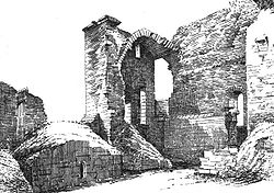
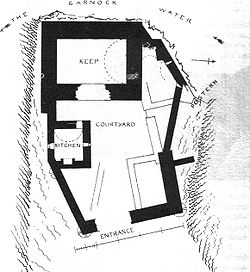
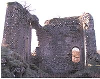
The castle is an example of a keep with courtyard attached and dates from the period 1400 - 1542, with various later buildings in the courtyard. "The ruins of Glengarnock Castle stand on a precipitous ridge or knoll, overhanging the Garnock, about two miles (3 km) north of Kilbirnie. This brawling stream skirts two sides of the knoll; and as the ravine through which it flows is fully eighty feet in depth, the position, under the ancient system of warfare, must have combined security with the means of easy defence. The only access to the castle is from the northeast, in which direction the ridge, upon which it is situated, is connected with the adjoining field. At the distance of thirty yards from its entrance, a depression in the ground indicates what has been the course of a dry moat, by which, and a drawbridge, the approach is said to have been protected. In 1956 this dry moat was still 30 metres in length and had an average depth of 4 metres with a width of 8 metres. Evidence in 1964 was recorded of a small building lying in between the dry moat and the castle, possibly a farmstead.
The ground-plan of this ancient stronghold could, until lately, be easily traced; and as a portion of the exterior walls still remains nearly the original height, its appearance when entire may, with little difficulty, be yet shadowed out. From notes and measurements taken a few years ago, it may be described in general terms, as having consisted of a quadrilateral tower, with a court of less elevated buildings extending from its east side. The entrance has been from the eastern extremity of the latter. This facade is 46 feet (14 m) long, and has been about 24 feet (7.3 m) in height. A court or passage, 59 feet (18 m) in length, lay between the entrance and the tower, on each side of which has been a range of two-storied apartments. The tower is 45 feet (13.7 m) long, 33 feet (10.1 m) wide, and its height has been above 40 feet (12.2 m).
 Its upper and now only accessible story has consisted of a hall occupying the whole extent within the walls, and the imbowed ceiling of which has been 20 feet (6.1 m) in height. It has been lighted both from the court and from the exterior walls. One of the windows overlooks the rugged chasm through which murmurs the Garnock, and from two narrow apertures facing the east, the eye may yet revel over a beautiful extent of the district bearing the same name as the old lords of the castle. From the hall, a narrow circular stair led to the upper part of the building, which has been surrounded by a parapet wall.
The ruins show neither the arrow-slit nor gun-port of defence, so common in similar old houses. Perhaps the situation was of itself so secure as to render unnecessary the ordinary means of repelling an attack. The uniformity of style in all castellated mansions, erected prior to the discovery of gunpowder, renders it hazardous to be precise regarding the date of their construction. Few, however, conversant with such remnants of feudal architecture, would hesitate to assign to the ruins of this stronghold, an antiquity as remote as that of any remains of masonry in the west of Scotland."
John Smith records in the 1890s that a substantial midden had built up below the castle over the years and this was largely formed from ashes from the typical local low quality coal, together with broken fragments of tiles and patterned glass with chipped and roughened edges.
Just below the castle on the River Garnock is Garrat's Linn, (linn being Scots for a pool in a river).
Keep
A keep is a type of fortified tower built within castles during the Middle Ages by European nobility. Scholars have debated the scope of the word keep, but usually consider it to refer to large towers in castles that were fortified residences, used as a refuge of last resort should the rest of the...
is located on a remote rocky promontory overlooking the River Garnock
River Garnock
The River Garnock, the smallest of Ayrshire's six principal rivers, has its source on the southerly side of the Hill of Stake in the heart of the Clyde Muirshiel Regional Park. About a mile and a half south of this starting point the untested stream tumbles over the Spout of Garnock, the highest...
about 2 miles (3.2 km) north of the town of Kilbirnie
Kilbirnie
Kilbirnie is a small town of 7280 inhabitants situated in North Ayrshire on the west coast of Scotland...
in North Ayrshire
North Ayrshire
North Ayrshire is one of 32 council areas in Scotland with a population of roughly 136,000 people. It is located in the south-west region of Scotland, and borders the areas of Inverclyde to the north, Renfrewshire to the north-east and East Ayrshire and South Ayrshire to the East and South...
, Scotland
Scotland
Scotland is a country that is part of the United Kingdom. Occupying the northern third of the island of Great Britain, it shares a border with England to the south and is bounded by the North Sea to the east, the Atlantic Ocean to the north and west, and the North Channel and Irish Sea to the...
. There is no clear account of when this was erected or by whom, but it may have been built by the Cunningham
Clan Cunningham
Clan Cunningham is a Scottish clan. The clan does not currently have a chief, therefore it is considered an Armigerous clan by the Standing Council of Scottish Chiefs, though recently two contenders for the chiefship have emerged...
(or Cunninghame) family or by the Riddels who preceded them. The ruins were stabilized in 1841 by W. C. Cochran of Ladyland
Barony of Ladyland
The Barony of Ladyland was in the old feudal Baillerie of Cunninghame, near Kilbirnie in what is now North Ayrshire, Scotland.- The history of the Barony of Ladyland :...
, following a partial collapse in a storm of 1839; the structure still continues to deteriorate.
History
In the 12th and 13th centuries, the lands here were held for the King by the De Morville familyRichard de Morville
Richard de Morville , succeeded his father Hugh de Morville as Constable of Scotland and in his Scottish estates and English lands at Bozeat in Northamptonshire, and Rutland, as well as a number of feus of the Honour of Huntingdon....
, hereditary Great Constables of Scotland. A castle may have been built here by them; a convenient site in relation to the abbey they founded at Kilwinning
Kilwinning Abbey
Kilwinning Abbey is a ruined abbey located in the centre of the town of Kilwinning, North Ayrshire.-The establishment of the Abbey:The ancient name of the town is 'Segdoune' or 'Saigtown', probably derived from 'Sanctoun', meaning the 'town of the saint'. Saint Winnings festival was on 21 January...
. The Barony of Glengarnock then passed to the Riddels and the Cunninghames. Mary, Queen of Scots, visited in 1563. Sir James Cunningham built the Glengarnock Aisle in Kilbirnie Auld Kirk
Kilbirnie Auld Kirk
Kilbirnie Auld Kirk is a Church of Scotland congregation on Dalry Road , Kilbirnie, North Ayrshire, Scotland. Although the building dates back to the 15th century, the present congregation was formed in 1978 by the amalgamation of Glengarnock Parish Church and the The Barony Church.- History...
in 1597. The Cunninghames retained the castle until the early 17th century and by the 18th century it had been abandoned.
Description
The castle is an example of a keep with courtyard attached and dates from the period 1400 - 1542, with various later buildings in the courtyard. "The ruins of Glengarnock Castle stand on a precipitous ridge or knoll, overhanging the Garnock, about two miles (3 km) north of Kilbirnie. This brawling stream skirts two sides of the knoll; and as the ravine through which it flows is fully eighty feet in depth, the position, under the ancient system of warfare, must have combined security with the means of easy defence. The only access to the castle is from the northeast, in which direction the ridge, upon which it is situated, is connected with the adjoining field. At the distance of thirty yards from its entrance, a depression in the ground indicates what has been the course of a dry moat, by which, and a drawbridge, the approach is said to have been protected. In 1956 this dry moat was still 30 metres in length and had an average depth of 4 metres with a width of 8 metres. Evidence in 1964 was recorded of a small building lying in between the dry moat and the castle, possibly a farmstead.
The ground-plan of this ancient stronghold could, until lately, be easily traced; and as a portion of the exterior walls still remains nearly the original height, its appearance when entire may, with little difficulty, be yet shadowed out. From notes and measurements taken a few years ago, it may be described in general terms, as having consisted of a quadrilateral tower, with a court of less elevated buildings extending from its east side. The entrance has been from the eastern extremity of the latter. This facade is 46 feet (14 m) long, and has been about 24 feet (7.3 m) in height. A court or passage, 59 feet (18 m) in length, lay between the entrance and the tower, on each side of which has been a range of two-storied apartments. The tower is 45 feet (13.7 m) long, 33 feet (10.1 m) wide, and its height has been above 40 feet (12.2 m).
The ruins show neither the arrow-slit nor gun-port of defence, so common in similar old houses. Perhaps the situation was of itself so secure as to render unnecessary the ordinary means of repelling an attack. The uniformity of style in all castellated mansions, erected prior to the discovery of gunpowder, renders it hazardous to be precise regarding the date of their construction. Few, however, conversant with such remnants of feudal architecture, would hesitate to assign to the ruins of this stronghold, an antiquity as remote as that of any remains of masonry in the west of Scotland."
John Smith records in the 1890s that a substantial midden had built up below the castle over the years and this was largely formed from ashes from the typical local low quality coal, together with broken fragments of tiles and patterned glass with chipped and roughened edges.
Just below the castle on the River Garnock is Garrat's Linn, (linn being Scots for a pool in a river).