

Gilgil
Encyclopedia
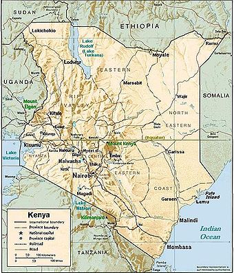
Kenya
Kenya , officially known as the Republic of Kenya, is a country in East Africa that lies on the equator, with the Indian Ocean to its south-east...
is a town in the Rift Valley Province of Kenya
Kenya
Kenya , officially known as the Republic of Kenya, is a country in East Africa that lies on the equator, with the Indian Ocean to its south-east...
. The town is located between Naivasha
Naivasha
Naivasha is a market town in Rift Valley Province, Kenya, lying north west of Nairobi. It is located on the shore of Lake Naivasha and along the Nairobi - Nakuru highway and Uganda Railway.Naivasha is part of the Nakuru District...
and Nakuru
Nakuru
Nakuru, the provincial capital of Kenya's Rift Valley province, with roughly 300,000 inhabitants, and currently the fourth largest urban centre in the country, lies about 1850 m above sea level...
and along the Nairobi
Nairobi
Nairobi is the capital and largest city of Kenya. The city and its surrounding area also forms the Nairobi County. The name "Nairobi" comes from the Maasai phrase Enkare Nyirobi, which translates to "the place of cool waters". However, it is popularly known as the "Green City in the Sun" and is...
- Nakuru highway. Gilgil has a population of 18,805 (according to the 1999 census) http://www.ilri.cgiar.org/html/Urban%20Poverty%20all%20Kenya%20Province%20through%20Location%20Final.xls. Gilgil is also the centre of the Gilgil division
Administrative divisions of Kenya
Kenya is divided into eight provinces . The provinces are subdivided into 46 districts which are further subdivided into 262 divisions. The divisions are subdivided into 2,427 locations and then 6,612 sublocations. A province is administered by a Provincial Commissioner .Kenyan local authorities...
in Nakuru District
Nakuru District
Nakuru District is a district in the Rift Valley Province, Kenya. The district capital is Nakuru. With a population of 1,187,039 , it is the second largest district in Kenya after Nairobi. Nakuru District has an area of 7,242 km²....
.
History
During the 1920s - 1940s, some members of the Happy Valley setHappy Valley set
The Happy Valley set was a group of privileged British colonials living in the Happy Valley region of the Wanjohi Valley,near the Aberdare mountain range, in the colonies of Kenya and Uganda during the 1920s - 1940s...
lived in Gilgil. In the 1940s it also contained a British
United Kingdom
The United Kingdom of Great Britain and Northern IrelandIn the United Kingdom and Dependencies, other languages have been officially recognised as legitimate autochthonous languages under the European Charter for Regional or Minority Languages...
internment camp for Irgun and Lehi
Irgun and Lehi internment in Africa
From 1944 to 1948, Irgun and Lehi men being held without trial at the Latroun concentration camp were deported by the British Mandate of Palestine authorities to internment camps in Africa, located in Sembel , Carthago, Sudan, and Gilgil...
members.
Economy
Agriculture is the main local industry while Gilgil Telecommunications Industries was a notable employer but is now closed down as it was sold by the government. There are a few industries within the outskirts of the town, namely the Gilgil Diatomite Industries which is located further to the west along the Gilgil-Nakuru main road. The industry mines diatomite which is used for various industrial purposes. The other industry is the Ndume Farm Machineries, which manufactures farm equipment;the industry is known for its maize milling machines and ploughs.Military
A main employer in the town remains the Ministry of Defense as the town hosts two major barracks, the Gilgil barracks located about 1 km from the Gilgil town center on the old Gilgil - Nakuru road and the Kenyatta Barracks which is also located about 2 km along the main Gilgil-Nyahururu road. The latter barracks is also known Westcom or Western command. The Gilgil barracks is home to the 5th Kenya Rifles also known as "the fighting five" while the Kenyatta Barracks is home to Kenya's only airborne battalion, the 20 Para and also home to the 66 Artillery brigade, the 76 Amoured Recce Battalion and the 1st Motar Battalion. Most of the towns folks thus largely rely on the military community in economic terms. In the recent past the members of the military both active and retired personnel have invested significantly in the town's property market and also in retail business. However, in the outskirts of the town there is some small-scale farming.Maps
http://maps.google.co.ke/maps?q=gilgil&oe=utf-8&rls=org.mozilla:en-US:official&client=firefox-a&um=1&ie=UTF-8&sa=N&hl=en&tab=wlStatistics
- Elevation = 2,000 metres (6,600 ft approx) above sea level
- Population = 21,081
See also
- Railway stations in KenyaRailway stations in Kenya- Maps :* * * - Existing :* Mombasa - ocean port* Changamwe* Miritini* Mazeras* Mariakani* Maji ya Chumvi* Samburu* Taru* Mackinnon Road* Mwanatibu* Buchuma* Wangala* Maungu* Ndara* Voi - junction** Mwatate** Bura** Mashoti** Maktau** Murka...
- Nyeri, Kenya - another town from colonial times.
- Alice de JanzéAlice de JanzéAlice de Janzé, née Silverthorne , also known as Alice de Trafford and holder of the noble title Comtesse de Janzé for a few years, was an American heiress who spent years in Kenya, as a member of the Happy Valley set of colonials...
- lived in Gilgil until 1941.