
Georgia State Route 70
Encyclopedia
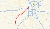
State Route 70 begins just east of Newnan, Georgia
at Millard Farmer Industrial Boulevard (S.R. 34 Bypass) and ends at Donald Lee Hollowell Parkway (U.S. 78/278/S.R. 8) in northwest Atlanta
(Bankhead
).
Upon reaching the southwestern portion of Atlanta, in unincorporated Fulton County
, S.R. 70 turns into Leroy Johnson-Fulton Industrial Boulevard (between I-20
and Donald Lee Hollowell Parkway/U.S. 78). At this point it is very heavily traveled, widening to a six-lane parkway. The state highway passes by Fulton County Airport at Charlie Brown Field
.
Once S.R. 70 reaches Campbellton
Road (S.R. 154/166), it merges with the above-mentioned roadway. The state highway follows Campbellton Road to the intersection of Fairburn Road (S.R. 92), where S.R. 70/154/166 merge with S.R. 92 south. S.R. 70/154 split from S.R. 92 at Cascade
-Palmetto
Highway, continuing south to South Fulton Parkway, where S.R. 70 splits from S.R. 154 and turns west onto the parkway en route to its original routing at Campbellton-Redwine Road. Just before the Douglas County line where South Fulton parkway turns into Capps Ferry Road, going southbound, SR 70 will turn left onto Campbellton-Redwine Rd where it continues it original routing for 4.2 miles (6.8 km) in which it goes into Coweta County. In Coweta County it changes names to Roscoe Rd, then almost immediately SR 70/Roscoe Rd goes through 2 sharp(70 degree) curves, one to the right then one immediately back to the left, assuming we are traveling southbound. After approxamently 1/4 mile, SR 70/Roscoe Rd will proceed with an extremely sharp(90 degree) curve to the right then immediately with one back to the left. It travels for approx. 8.5 miles (13.7 km) in Coweta County before coming to the intersection of State Route 34 Bypass where SR 70 will terminate.
The re-routing of SR 70 westward along Campbellton Road crossing the Chattahoochee River now takes the route into Douglas County before turning south and back across the Chattahoochee River and returning to southern Fulton County. The stretch of Fulton Industrial Boulevard between Campbellton Road and Fairburn Road is no longer assigned a State routing number. This four mile stretch was formerly SR 70 and SR 154. The stretch of Fairburn Road from Campbellton Road to SR 166 in southeast Douglas County now carries the unusual distinction of being assigned 4 state route numbers. This stretch is now SR 70/92/154/166.
Newnan, Georgia
Newnan is a city in Coweta County, Georgia, about 30 miles southwest of Atlanta. The population was 16,242 at the 2000 Census. Newnan is one of the fastest growing cities in Georgia, with an estimated population of 27,097 in 2006 and 33,293 in July 2008...
at Millard Farmer Industrial Boulevard (S.R. 34 Bypass) and ends at Donald Lee Hollowell Parkway (U.S. 78/278/S.R. 8) in northwest Atlanta
Atlanta, Georgia
Atlanta is the capital and most populous city in the U.S. state of Georgia. According to the 2010 census, Atlanta's population is 420,003. Atlanta is the cultural and economic center of the Atlanta metropolitan area, which is home to 5,268,860 people and is the ninth largest metropolitan area in...
(Bankhead
Bankhead (Atlanta)
Bankhead is an Atlanta, Georgia neighborhood located west of downtown Atlanta. It's surrounded by Grove Park to the west, Washington Park and Hunter Hills to the South, Midtown West to the East and Northeast . It is also flanked by Rockdale to the Northwest. At its center is MARTA's Bankhead...
).
Upon reaching the southwestern portion of Atlanta, in unincorporated Fulton County
Fulton County, Georgia
Fulton County is a county located in the U.S. state of Georgia. Its county seat is Atlanta, the state capital since 1868 and the principal county of the Atlanta metropolitan area...
, S.R. 70 turns into Leroy Johnson-Fulton Industrial Boulevard (between I-20
Interstate 20
Interstate 20 is a major east–west Interstate Highway in the Southern United States. I‑20 runs 1,535 miles from near Kent, Texas, at Interstate 10 to Florence, South Carolina, at Interstate 95...
and Donald Lee Hollowell Parkway/U.S. 78). At this point it is very heavily traveled, widening to a six-lane parkway. The state highway passes by Fulton County Airport at Charlie Brown Field
Fulton County Airport (Georgia)
Fulton County Airport at Charlie Brown Field is a local Class D airport located just west of Atlanta, and run by Fulton County of the U.S. state of Georgia. It is the nearest airport to Hartsfield-Jackson Atlanta International Airport , and handles much of the general aviation traffic that would...
.
Once S.R. 70 reaches Campbellton
Campbellton, Georgia
Campbellton is an unincorporated town in southwestern Fulton County, Georgia, that lies along the banks of the Chattahoochee River. The area prior to white settlement was populated by the Creek Indians. Campbellton was settled by several families. The Beavers Family owned and farmed a large...
Road (S.R. 154/166), it merges with the above-mentioned roadway. The state highway follows Campbellton Road to the intersection of Fairburn Road (S.R. 92), where S.R. 70/154/166 merge with S.R. 92 south. S.R. 70/154 split from S.R. 92 at Cascade
Cascade Heights
Cascade Heights is an affluent predominantly African-American neighborhood in southwest Atlanta. Along with Sandtown and other portions of unincorporated South Fulton County, the area has a reputation as having a high concentration of the African-American elite in the city.Cascade Heights, or...
-Palmetto
Palmetto, Georgia
Palmetto is a city located mostly in Fulton County and now partly in Coweta County in the U.S. state of Georgia...
Highway, continuing south to South Fulton Parkway, where S.R. 70 splits from S.R. 154 and turns west onto the parkway en route to its original routing at Campbellton-Redwine Road. Just before the Douglas County line where South Fulton parkway turns into Capps Ferry Road, going southbound, SR 70 will turn left onto Campbellton-Redwine Rd where it continues it original routing for 4.2 miles (6.8 km) in which it goes into Coweta County. In Coweta County it changes names to Roscoe Rd, then almost immediately SR 70/Roscoe Rd goes through 2 sharp(70 degree) curves, one to the right then one immediately back to the left, assuming we are traveling southbound. After approxamently 1/4 mile, SR 70/Roscoe Rd will proceed with an extremely sharp(90 degree) curve to the right then immediately with one back to the left. It travels for approx. 8.5 miles (13.7 km) in Coweta County before coming to the intersection of State Route 34 Bypass where SR 70 will terminate.
The re-routing of SR 70 westward along Campbellton Road crossing the Chattahoochee River now takes the route into Douglas County before turning south and back across the Chattahoochee River and returning to southern Fulton County. The stretch of Fulton Industrial Boulevard between Campbellton Road and Fairburn Road is no longer assigned a State routing number. This four mile stretch was formerly SR 70 and SR 154. The stretch of Fairburn Road from Campbellton Road to SR 166 in southeast Douglas County now carries the unusual distinction of being assigned 4 state route numbers. This stretch is now SR 70/92/154/166.