
Georgia State Route 6
Encyclopedia
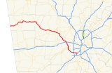
State Route 6 begins at the Georgia
-Alabama
state line southwest of Cedartown
in Esom Hill and ends at I-85
, exit 72, in College Park
. State Route 6 is the state designation for U.S. 278 from the Alabama border to U.S. 78 in Douglas County
. The eastern end of Tuskegee Airmen Parkway (SR 6) carries traffic to Interstate 85 and the Atlanta Airport
.
in East Point, there has been a renaissance for south Fulton County
: the opening of the Camp Creek MarketPlace. It was opened in late 2003, and the second portion opened in spring or summer of 2006.
On August 1, 2008, Camp Creek Parkway (The 12 miles (19.3 km) stretch of SR 6, between Fulton Industrial Boulevard and Interstate 85) was honorarily designated Tuskegee Airmen Parkway.
As of March 2009, the portion of the route in Fulton County is no longer signed as State Route 6. The only signage on this route are the Tuskegee Airmen Parkway signs. The portion near I-285 and the Atlanta Airport, which is in Clayton County, is still signed as State Route 6.
Georgia (U.S. state)
Georgia is a state located in the southeastern United States. It was established in 1732, the last of the original Thirteen Colonies. The state is named after King George II of Great Britain. Georgia was the fourth state to ratify the United States Constitution, on January 2, 1788...
-Alabama
Alabama
Alabama is a state located in the southeastern region of the United States. It is bordered by Tennessee to the north, Georgia to the east, Florida and the Gulf of Mexico to the south, and Mississippi to the west. Alabama ranks 30th in total land area and ranks second in the size of its inland...
state line southwest of Cedartown
Cedartown, Georgia
Cedartown is a city in Polk County, Georgia, United States. As of the 2010 census, the city had a population of 9,750. The city is the county seat of Polk County...
in Esom Hill and ends at I-85
Interstate 85 in Georgia
In the U.S. state of Georgia, the major Interstate Highway, Interstate 85, runs northeast-southwest from the Alabama border near West Point, and Lanett, Ala., running through Metropolitan Atlanta, and traveling to the border with South Carolina, where it crosses the Savannah River near Lake Hartwell...
, exit 72, in College Park
College Park, Georgia
College Park is a city located partly in Fulton County, Georgia and partially in Clayton County, Georgia, in the United States. As of the 2010 census, the city population was 13,942...
. State Route 6 is the state designation for U.S. 278 from the Alabama border to U.S. 78 in Douglas County
Douglas County, Georgia
Douglas County, Georgia has been experiencing numerous natural disasters over the most recent decades. Being located in the South Eastern United States the county experiences strong storms and tornadoes often because of its location in Dixie Alley....
. The eastern end of Tuskegee Airmen Parkway (SR 6) carries traffic to Interstate 85 and the Atlanta Airport
Hartsfield-Jackson Atlanta International Airport
Hartsfield–Jackson Atlanta International Airport , known locally as Atlanta Airport, Hartsfield Airport, and Hartsfield–Jackson, is located seven miles south of the central business district of Atlanta, Georgia, United States...
.
History
Recently, at the intersection of Tuskegee Airmen Parkway (SR 6) and I-285Interstate 285
Interstate 285 is an Interstate Highway loop encircling Atlanta, Georgia, for . I-285 is also known as unsigned State Route 407 and is colloquially referred to as the Perimeter. Suburban sprawl has made it one of the most heavily traveled roadways in the United States, and portions of the highway...
in East Point, there has been a renaissance for south Fulton County
Fulton County, Georgia
Fulton County is a county located in the U.S. state of Georgia. Its county seat is Atlanta, the state capital since 1868 and the principal county of the Atlanta metropolitan area...
: the opening of the Camp Creek MarketPlace. It was opened in late 2003, and the second portion opened in spring or summer of 2006.
On August 1, 2008, Camp Creek Parkway (The 12 miles (19.3 km) stretch of SR 6, between Fulton Industrial Boulevard and Interstate 85) was honorarily designated Tuskegee Airmen Parkway.
As of March 2009, the portion of the route in Fulton County is no longer signed as State Route 6. The only signage on this route are the Tuskegee Airmen Parkway signs. The portion near I-285 and the Atlanta Airport, which is in Clayton County, is still signed as State Route 6.