
Georgia State Route 48
Encyclopedia
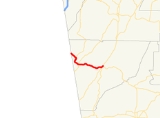
State Route 48 is a short west–east state route located entirely in Chattooga County
in the northwestern part of the U.S. state
of Georgia
. The route travels from State Route 117 (Alabama) at the Alabama
state line northwest of Menlo
to U.S. Route 27
/State Route 1 in Summerville
.
. The route intersects State Route 157 at S.R. 157's southern terminus in the community of Cloudland. State Route 48 then descends from Lookout Mountain into the town of Menlo, where it intersects State Route 337
. State Route 48 continues east to Summerville, where it meets its eastern terminus at U.S. Route 27/State Route 1 in downtown.
While the route is short, State Route 48 is a somewhat important route in the area. Between Menlo and Summerville, the route sees an Average Annual Daily Traffic over 5,000 vehicles.
Chattooga County, Georgia
Chattooga County is a county located in the U.S. state of Georgia. It was created on December 28, 1838. As of 2000, the population was 25,470. The 2007 Census Estimate shows a population of 26,797. The county seat is Summerville.-Geography:...
in the northwestern part of the U.S. state
U.S. state
A U.S. state is any one of the 50 federated states of the United States of America that share sovereignty with the federal government. Because of this shared sovereignty, an American is a citizen both of the federal entity and of his or her state of domicile. Four states use the official title of...
of Georgia
Georgia (U.S. state)
Georgia is a state located in the southeastern United States. It was established in 1732, the last of the original Thirteen Colonies. The state is named after King George II of Great Britain. Georgia was the fourth state to ratify the United States Constitution, on January 2, 1788...
. The route travels from State Route 117 (Alabama) at the Alabama
Alabama
Alabama is a state located in the southeastern region of the United States. It is bordered by Tennessee to the north, Georgia to the east, Florida and the Gulf of Mexico to the south, and Mississippi to the west. Alabama ranks 30th in total land area and ranks second in the size of its inland...
state line northwest of Menlo
Menlo, Georgia
Menlo is a city in Chattooga County, Georgia, United States. The population was 485 at the 2000 census.-Geography:Menlo is located at .According to the United States Census Bureau, the city has a total area of , all of it land....
to U.S. Route 27
U.S. Route 27
U.S. Route 27 is a north–south United States highway in the southern and midwestern United States. The southern terminus is at US 1 in Miami, Florida. The northern terminus is at Interstate 69 in Fort Wayne, Indiana...
/State Route 1 in Summerville
Summerville, Georgia
Summerville is a city in Chattooga County, Georgia, United States. The population was 4,556 at the 2000 census. The city is the county seat of Chattooga County.- Geography :Summerville is located at ....
.
Route description
From its western terminus at the Alabama state line, where Alabama State Route 117 crosses the state line into Georgia, State Route 48 travels southeast, across Lookout MountainLookout Mountain
thumb|right|See seven statesLookout Mountain is located at the northwest corner of the U.S. state of Georgia, the northeast corner of Alabama, and along the southern border of Tennessee at Chattanooga. Lookout Mountain, along with Sand Mountain to the northwest, makes up a large portion of the...
. The route intersects State Route 157 at S.R. 157's southern terminus in the community of Cloudland. State Route 48 then descends from Lookout Mountain into the town of Menlo, where it intersects State Route 337
State Route 337 (Georgia)
State Route 337 is a northeast-southwest route that runs from its southern terminus at the Alabama state line southwest of Menlo northeastward through Broomtown Valley at the foot of Lookout Mountain. The route reaches its northern terminus at U.S. 27/S.R. 1 south of LaFayette, though the route...
. State Route 48 continues east to Summerville, where it meets its eastern terminus at U.S. Route 27/State Route 1 in downtown.
While the route is short, State Route 48 is a somewhat important route in the area. Between Menlo and Summerville, the route sees an Average Annual Daily Traffic over 5,000 vehicles.