

Geography of Western Sahara
Encyclopedia
| Geography of Western Sahara | |
 |
|
| Continent | Africa Africa Africa is the world's second largest and second most populous continent, after Asia. At about 30.2 million km² including adjacent islands, it covers 6% of the Earth's total surface area and 20.4% of the total land area... |
| Region | North Africa North Africa North Africa or Northern Africa is the northernmost region of the African continent, linked by the Sahara to Sub-Saharan Africa. Geopolitically, the United Nations definition of Northern Africa includes eight countries or territories; Algeria, Egypt, Libya, Morocco, South Sudan, Sudan, Tunisia, and... |
| Coordinates | 24°30′N 13°00′W |
| Area | Ranked 77th 266,000 km2 |
| Coastline | 1,110 km |
| Borders | 2,046 km (Algeria Algeria Algeria , officially the People's Democratic Republic of Algeria , also formally referred to as the Democratic and Popular Republic of Algeria, is a country in the Maghreb region of Northwest Africa with Algiers as its capital.In terms of land area, it is the largest country in Africa and the Arab... 42 km, Mauritania Mauritania Mauritania is a country in the Maghreb and West Africa. It is bordered by the Atlantic Ocean in the west, by Western Sahara in the north, by Algeria in the northeast, by Mali in the east and southeast, and by Senegal in the southwest... 1,561 km, Morocco Morocco Morocco , officially the Kingdom of Morocco , is a country located in North Africa. It has a population of more than 32 million and an area of 710,850 km², and also primarily administers the disputed region of the Western Sahara... 443 km) |
| Highest point | unnamed elevation 805 m |
| Lowest point | Sebjet Tah, -55 m |
Western Sahara
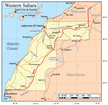
Western Sahara is a disputed territory in North Africa, bordered by Morocco to the north, Algeria to the northeast, Mauritania to the east and south, and the Atlantic Ocean to the west. Its surface area amounts to . It is one of the most sparsely populated territories in the world, mainly...
is a territory in Northern Africa
Africa
Africa is the world's second largest and second most populous continent, after Asia. At about 30.2 million km² including adjacent islands, it covers 6% of the Earth's total surface area and 20.4% of the total land area...
, bordered by the North Atlantic Ocean
Atlantic Ocean
The Atlantic Ocean is the second-largest of the world's oceanic divisions. With a total area of about , it covers approximately 20% of the Earth's surface and about 26% of its water surface area...
, Morocco
Morocco
Morocco , officially the Kingdom of Morocco , is a country located in North Africa. It has a population of more than 32 million and an area of 710,850 km², and also primarily administers the disputed region of the Western Sahara...
proper, Algeria
Algeria
Algeria , officially the People's Democratic Republic of Algeria , also formally referred to as the Democratic and Popular Republic of Algeria, is a country in the Maghreb region of Northwest Africa with Algiers as its capital.In terms of land area, it is the largest country in Africa and the Arab...
(Tindouf
Tindouf
Tindouf is the main town in Tindouf Province, Algeria, close to the Mauritanian and Moroccan borders. The region is considered of strategic significance, and it houses Algerian military bases. Since 1975, it also contains several Sahrawi refugee camps operated by the Polisario Front a guerrilla...
region), and Mauritania
Mauritania
Mauritania is a country in the Maghreb and West Africa. It is bordered by the Atlantic Ocean in the west, by Western Sahara in the north, by Algeria in the northeast, by Mali in the east and southeast, and by Senegal in the southwest...
. Geographic coordinates: 24°30′N 13°00′W
Size
Total: 266,060 km²- land: 266,000 km²
- water: 0 km²
- Coastline: 1,110 km;
- Land boundaries: 2,046 km
- Saguia el-HamraSaguia el-HamraSaguia el-Hamra, in Arabic الساقية الحمراء, al-Saqiyah al-Hamra'a , is, with Río de Oro, one of the two territories that formed the Spanish province of Spanish Sahara after 1969. Its name comes from a waterway that goes through the capital....
is the northern third with the city El AaiúnEl AaiúnEl-Aaiún , is a city in Western Sahara founded by the Spanish in 1928. Administered by Morocco since 1976, El-Aaiún is the capital of what the Moroccan government call the region of Laâyoune-Boujdour-Sakia El Hamra, and POLISARIO call Occupied Territories...
. - Río de OroRío de OroRío de Oro , is, with Saguia el-Hamra, one of the two territories that formed the Spanish province of Spanish Sahara after 1969; it was originally taken as a Spanish colonial possession in the late 19th century...
is the southern two-thirds (south of Cape BojadorCape BojadorCape Bojador or Cape Boujdour is a headland on the northern coast of Western Sahara, at 26° 07' 37"N, 14° 29' 57"W. , as well as the name of a nearby town with a population of 41,178.It is shown on nautical charts with the original Portuguese name "Cabo Bojador", but is sometimes...
), with the city DakhlaDakhla, Western Sahara-External links:**...
.
The peninsula in the extreme southwest, with the city of Lagouira
Lagouira
La Güera or La Gouera is a town on the Atlantic coast at the southern tip of Western Sahara, on the western side of the Ras Nouadhibou peninsula...
, is called Ras Nouadhibou
Nouadhibou
Nouadhibou is the second largest city in Mauritania and serves as a major commercial centre. The city itself has about 75,000 inhabitants expanding to over 90,000 in the larger metropolitan area. It is situated on a 40-mile peninsula or headland called Ras Nouadhibou, Cap Blanc, or Cabo Blanco, of...
, Cap Blanc, or Cabo Blanco. The eastern side is part of Mauritania.
Maritime claims: contingent upon resolution of sovereignty issue
Western Sahara War
The Western Sahara War was an armed conflict primarily between the Polisario Front and Morocco, the conflict erupted after the withdrawal of Spain from the Spanish Sahara in accordance with the Madrid Accords by which it gave administrative control of the territory to Morocco and Mauritania...
Terrain
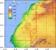
The terrain is mostly low, flat desert with large areas of rocky or sandy surfaces rising to small mountains in south and northeast.Elevation extremes:
- Lowest point: Sebjet Tah -55 m
- Highest point: unnamed location 463 m
Land use
Arable land: 0%
permanent crops: 0%
permanent pastures: 19%
forests and woodland: 0%
other: 81%
Irrigated land: NA km²
Natural hazards
Hot, dry, dust/sand-laden siroccoSirocco
Sirocco, scirocco, , jugo or, rarely, siroc is a Mediterranean wind that comes from the Sahara and reaches hurricane speeds in North Africa and Southern Europe. It is known in North Africa by the Arabic word qibli or ghibli Sirocco, scirocco, , jugo or, rarely, siroc is a Mediterranean wind...
wind can occur during winter and spring; widespread harmattan haze exists 60% of time, often severely restricting visibility. Flash flooding occurs during spring months.
Climate
It has a climate that is hot, dry desert; cold offshore air currents produce fog and heavy dew.Extreme points
This is a list of the extreme points of Western SaharaWestern Sahara
Western Sahara is a disputed territory in North Africa, bordered by Morocco to the north, Algeria to the northeast, Mauritania to the east and south, and the Atlantic Ocean to the west. Its surface area amounts to . It is one of the most sparsely populated territories in the world, mainly...
, the points that are farther north, south, east or west than any other location.
- Northern-most point – the border with MoroccoMoroccoMorocco , officially the Kingdom of Morocco , is a country located in North Africa. It has a population of more than 32 million and an area of 710,850 km², and also primarily administers the disputed region of the Western Sahara...
* - Eastern-most point – the northern section of the border with MauritaniaMauritaniaMauritania is a country in the Maghreb and West Africa. It is bordered by the Atlantic Ocean in the west, by Western Sahara in the north, by Algeria in the northeast, by Mali in the east and southeast, and by Senegal in the southwest...
/AlgeriaAlgeriaAlgeria , officially the People's Democratic Republic of Algeria , also formally referred to as the Democratic and Popular Republic of Algeria, is a country in the Maghreb region of Northwest Africa with Algiers as its capital.In terms of land area, it is the largest country in Africa and the Arab...
** - Southern-most point – the southern tip of Ras NouadhibouRas NouadhibouRas Nouadhibou is a 40-mile peninsula or headland in the African coast of the Atlantic Ocean by the Tropic of Cancer. It is internationally known as Cap Blanc in French or Cabo Blanco in Spanish .- History :...
/(Cap Blanc) - Western-most point - Cape Dubouchage on Ras Nouadhibou
- *Note: Western Sahara does not have a northern-most point, the border being formed by a straight horizontal line
- **Note: Western Sahara does not have an eastern-most point, the border being formed by a straight vertical line