

Geography of Omaha
Encyclopedia
Omaha, Nebraska
Omaha is the largest city in the state of Nebraska, United States, and is the county seat of Douglas County. It is located in the Midwestern United States on the Missouri River, about 20 miles north of the mouth of the Platte River...
is characterized by its riverfront position alongside the Missouri River
Missouri River
The Missouri River flows through the central United States, and is a tributary of the Mississippi River. It is the longest river in North America and drains the third largest area, though only the thirteenth largest by discharge. The Missouri's watershed encompasses most of the American Great...
. The city's geography, with its proximity to the river was a factor in making Omaha the "Gateway of the West" from which thousands of settlers traveled into the American West during the 19th century. Environmental issues include more than one hundred years of industrial smelting along the riverfront along with the continuous impact of suburban sprawl on the city's west side. The city's climate is temperate.
Geography
Omaha is located at 41°15′38"N 96°0′47"W. According to the United States Census BureauUnited States Census Bureau
The United States Census Bureau is the government agency that is responsible for the United States Census. It also gathers other national demographic and economic data...
, the city has a total area of 118.9 square miles (307.9 km²). 115.7 square miles (299.7 km²) of it is land and 3.2 square miles (8.2 km²) of it is water. The total area is 2.67% water.
Situated in the Midwestern United States
Midwestern United States
The Midwestern United States is one of the four U.S. geographic regions defined by the United States Census Bureau, providing an official definition of the American Midwest....
on the shore of the Missouri River in eastern Nebraska
Nebraska
Nebraska is a state on the Great Plains of the Midwestern United States. The state's capital is Lincoln and its largest city is Omaha, on the Missouri River....
, the Port of Omaha
Port of Omaha
The Port of Omaha is a port of entry in the United States with facilities on the west side of the Missouri River in Omaha, Nebraska. The official address is located at 5229 Boeing Court in East Omaha. The Port was formally sanctioned by the U.S. Congress in 1888.- About :Founded immediately on the...
helped the city grow in significance as a trading city. Much of Omaha is built in the Missouri River Valley
Missouri River Valley
The Missouri River Valley outlines the journey of the Missouri River from its headwaters where the Madison, Jefferson and Gallatin Rivers flow together in Montana to its confluence with the Mississippi River in the State of Missouri. At long the valley drains one-sixth of the United States, and is...
. Other significant bodies of water in the Omaha-Council Bluffs metropolitan area
Omaha-Council Bluffs metropolitan area
The Omaha-Council Bluffs metropolitan area is a metropolitan area comprising the cities of Omaha, Nebraska, Council Bluffs, Iowa, and surrounding areas. The Omaha-Council Bluffs metropolitan area has a population of 865,350 . The metropolitan area, as defined by the Office of Management and Budget,...
include Lake Manawa, Papillion Creek
Papillion Creek
Papillion Creek is a tributary of the Missouri River in Nebraska. Its watershed lies in Washington, Douglas and Sarpy counties, including parts of the city of Omaha. The main branch of Papillion Creek is known as Big Papillion Creek...
, Carter Lake, Platte River
Platte River
The Platte River is a major river in the state of Nebraska and is about long. Measured to its farthest source via its tributary the North Platte River, it flows for over . The Platte River is a tributary of the Missouri River, which in turn is a tributary of the Mississippi River which flows to...
and the Glenn Cunningham Lake
Glenn Cunningham Lake
Glenn Cunningham Lake is located in Omaha, Nebraska, United States. The park is located along 96th Street with entrances at State Highway 36, State Street, 96th Street and Rainwood Road. The lake is a part of Little Papillion Creek, which is part of the Papillion Creek watershed.Glenn Cunningham...
.
The city's land has been altered considerably by human intervention, with substantial regrading
Regrading
Regrading is the process of raising and/or lowering the levels of land; such a project can also be referred to as a regrade. Regrading may be done on a small scale or on quite a large scale...
throughout Downtown Omaha
Downtown Omaha
Downtown Omaha is the central business, government and social core of the Omaha-Council Bluffs metropolitan area, and is located in Omaha, Nebraska. The boundaries are 20th Street on the west to the Missouri River on the east and the centerline of Leavenworth Street on the south to the centerline...
and scattered across the city. Minor land reclamation
Land reclamation
Land reclamation, usually known as reclamation, is the process to create new land from sea or riverbeds. The land reclaimed is known as reclamation ground or landfill.- Habitation :...
efforts, along with dam
Dam
A dam is a barrier that impounds water or underground streams. Dams generally serve the primary purpose of retaining water, while other structures such as floodgates or levees are used to manage or prevent water flow into specific land regions. Hydropower and pumped-storage hydroelectricity are...
s further upstream, have brought dozens of acres along the Missouri into usage. Many of the natural variations in topography have been evened out.
The highest natural point in the city is Belvedere Point in North Omaha.
East Omaha sits on a flood plain west of the Missouri River
Missouri River
The Missouri River flows through the central United States, and is a tributary of the Mississippi River. It is the longest river in North America and drains the third largest area, though only the thirteenth largest by discharge. The Missouri's watershed encompasses most of the American Great...
. The area is the location of Carter Lake, an oxbow lake
Oxbow lake
An oxbow lake is a U-shaped body of water formed when a wide meander from the main stem of a river is cut off to create a lake. This landform is called an oxbow lake for the distinctive curved shape, named after part of a yoke for oxen. In Australia, an oxbow lake is called a billabong, derived...
. The lake was once the site of East Omaha Island. In the crux of Carter Drive is an unnamed sulphur spring, and located south of there is Hardwood Creek. East Omaha was once the location of Florence Lake, which dried up at some point in the 1920s.
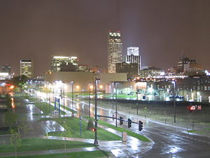
Cityscape
Similar to many other Western U.S. cities, Omaha was developed on a grid planGrid plan
The grid plan, grid street plan or gridiron plan is a type of city plan in which streets run at right angles to each other, forming a grid...
with the city center at the Missouri River
Missouri River
The Missouri River flows through the central United States, and is a tributary of the Mississippi River. It is the longest river in North America and drains the third largest area, though only the thirteenth largest by discharge. The Missouri's watershed encompasses most of the American Great...
and Dodge Street. This intersection was initially near the Lone Tree Ferry
Lone Tree Ferry
The Lone Tree Ferry, later known as the Council Bluffs and Nebraska Ferry Company, was the crossing of the Missouri River at Council Bluffs, Iowa, and Omaha, Nebraska, US, that was established in 1850 by William D. Brown...
, Omaha's impetus for founding; today the city's downtown
Downtown Omaha
Downtown Omaha is the central business, government and social core of the Omaha-Council Bluffs metropolitan area, and is located in Omaha, Nebraska. The boundaries are 20th Street on the west to the Missouri River on the east and the centerline of Leavenworth Street on the south to the centerline...
surrounds the area.
Neighborhoods
An expansive city covering substantial area, Omaha has many distinct neighborhoods. Dozens of small neighborhoods spread across several distinct areas in the city's core areas of Downtown OmahaDowntown Omaha
Downtown Omaha is the central business, government and social core of the Omaha-Council Bluffs metropolitan area, and is located in Omaha, Nebraska. The boundaries are 20th Street on the west to the Missouri River on the east and the centerline of Leavenworth Street on the south to the centerline...
, Midtown Omaha
Midtown Omaha
Midtown is a geographic area of Omaha, Nebraska that is a culturally, socially and economically important area of the city. It is home to major research centers, national corporations, several historic districts, and a number of historic residences.-About:...
, South Omaha and North Omaha. West Omaha, Northwest Omaha
Northwest Omaha
Northwest Omaha is a community area in Omaha, Nebraska. It holds several neighborhoods. The area is loosely bound by West Maple Road to the south, the Douglas-Washington County line to the north, Elkhorn to the west, and McKinley Street, I-680, and 72nd Street to the east.-Neighborhoods:Northwest...
, Southwest Omaha and several Sarpy County
Sarpy County, Nebraska
-Demographics:As of the census of 2000, there were 122,595 people, 43,426 households, and 33,220 families residing in the county. The population density was 510 people per square mile . There were 44,981 housing units at an average density of 187 per square mile...
cities and towns surround the city.
Climate
Though located at approximately the same latitude as Rome, Italy, Omaha, by virtue of its location near the center of North America far from large bodies of water or mountain ranges, has a humid continental climateHumid continental climate
A humid continental climate is a climatic region typified by large seasonal temperature differences, with warm to hot summers and cold winters....
(Koppen climate classification
Köppen climate classification
The Köppen climate classification is one of the most widely used climate classification systems. It was first published by Crimea German climatologist Wladimir Köppen in 1884, with several later modifications by Köppen himself, notably in 1918 and 1936...
Dfa), with hot summers and cold winters. Average July maximum and minimum temperatures are 87.4 °F (30.8 °C) and 65.9 °F (18.8 °C) respectively, with moderate humidity and relatively frequent thunderstorms, usually rather violent and capable of spawning severe weather or tornadoes; the January counterparts are 31.7 °F (-.2 °C) and 11.6 °F (-11.3 °C), though temperatures may easily fall below 0 °F (-18 °C) or rise above 50 °F (10 °C). The maximum temperature recorded in the city is 114 °F (46 °C), the minimum -32 F. Average yearly precipitation is 30.2 inches (767.1 mm), falling mostly in the warmer months, as winter precipitation is more often in the form of lower-moisture-content snowfall, averaging 26.8 inches (68 cm) per season.
Omaha has had its share of natural disasters by water and wind. The city's Carter Lake was formed by a massive flood which altered the course of the Missouri River. The Great Flood of 1881
Great Flood of 1881
The Great Flood of 1881 refers to flooding events on the Missouri River during the spring of 1881. The flood struck Omaha, Nebraska and Council Bluffs, Iowa between April 1, 1881 and April 27, 1881...
filled Omaha and Council Bluffs with water for almost a month, causing two fatalities and millions of dollars in damage. As many as 1,000 people were displaced by a flood in 1943, which sent the Missouri River, Carter Lake, and the old Florence Lake into homes and businesses throughout East Omaha. The flood of April 13, 1952 led to 40,000 people being evacuated from East Omaha and Carter Lake. President Harry S. Truman
Harry S. Truman
Harry S. Truman was the 33rd President of the United States . As President Franklin D. Roosevelt's third vice president and the 34th Vice President of the United States , he succeeded to the presidency on April 12, 1945, when President Roosevelt died less than three months after beginning his...
personally visited the scene of the flooding in Omaha and officially declared it a disaster area.
Several neighborhoods in Midtown and North Omaha were severely damaged by the Easter Sunday tornado of 1913, which destroyed many businesses and neighborhoods. More than 200 people died during the event. The Omaha Tornado of 1975
Omaha Tornado of 1975
The 1975 Omaha tornado is a violent tornado that hit the Omaha, Nebraska metropolitan area. It was part of a two-day outbreak that struck the Midwest and Southern United States on May 6–7, 1975, ending in the very early hours of May 8 across Louisiana. South Dakota, Iowa, Texas and Mississippi were...
cut through 10 miles of streets and residences, crossing the city's busiest intersection at 72nd and Dodge. Three people were killed and 133 were reported injured.
Environmental concerns
A recent report named northeast Omaha "one of the most dangerous toxic waste sites in the nation" after the United States Environmental Protection AgencyUnited States Environmental Protection Agency
The U.S. Environmental Protection Agency is an agency of the federal government of the United States charged with protecting human health and the environment, by writing and enforcing regulations based on laws passed by Congress...
(EPA) showed that more than 2,600 children in the area have lead poisoning. In early 2003, a large section of East Omaha was declared a Superfund
Superfund
Superfund is the common name for the Comprehensive Environmental Response, Compensation, and Liability Act of 1980 , a United States federal law designed to clean up sites contaminated with hazardous substances...
site after thousands of yards tested positive for high levels of lead contamination resulting from a nearby lead smeltering plant that operated for more than a century.
Natural disasters
In 1877 Omaha's Carter Lake was formed by a massive flood which altered the course of the Missouri River. The Great Flood of 1881Great Flood of 1881
The Great Flood of 1881 refers to flooding events on the Missouri River during the spring of 1881. The flood struck Omaha, Nebraska and Council Bluffs, Iowa between April 1, 1881 and April 27, 1881...
filled the Omaha and Council Bluffs with water for almost a month, causing two fatalities and millions of dollars in damage. As many as 1,000 people were displaced by a flood in 1943, which sent the Missouri River, Carter Lake
Carter Lake
Carter Lake may refer the following places:* The city of Carter Lake, Iowa* Carter Lake , a reservoir near Loveland, Colorado* Carter Lake , an oxbow lake on the Iowa-Nebraska border that gives the city of Carter Lake its name...
, and the old Florence Lake into peoples' homes and businesses throughout East Omaha. The flood of April 13, 1952 led to 40,000 people being evacuated from East Omaha and Carter Lake. President Harry S. Truman
Harry S. Truman
Harry S. Truman was the 33rd President of the United States . As President Franklin D. Roosevelt's third vice president and the 34th Vice President of the United States , he succeeded to the presidency on April 12, 1945, when President Roosevelt died less than three months after beginning his...
personally visited the scene of the flooding in Omaha and officially declared it a disaster area.
Several neighborhoods in central Omaha
Midtown Omaha
Midtown is a geographic area of Omaha, Nebraska that is a culturally, socially and economically important area of the city. It is home to major research centers, national corporations, several historic districts, and a number of historic residences.-About:...
and North Omaha were severely damaged by the Easter Sunday tornado of 1913, which destroyed many businesses and neighborhoods. More than 200 people died during the event. The Omaha Tornado of 1975
Omaha Tornado of 1975
The 1975 Omaha tornado is a violent tornado that hit the Omaha, Nebraska metropolitan area. It was part of a two-day outbreak that struck the Midwest and Southern United States on May 6–7, 1975, ending in the very early hours of May 8 across Louisiana. South Dakota, Iowa, Texas and Mississippi were...
moved across 10 miles (16.1 km) of streets and residences, crossing the city's busiest intersection at 72nd & Dodge. Three people were killed and 133 reported injured. Over 4,000 buildings were damaged and 287 were destroyed. In terms of damage, it was the costliest tornado in American history to that date, with insurance costs estimated at up to $1.1 billion (in 1975 dollars).