Gambir
Encyclopedia

Subdistricts of Indonesia
In Indonesia, a kecamatan or district is a subdivision of a regency or of a city . A district is itself divided into kelurahan or administrative villages....
of Central Jakarta
Central Jakarta
Central Jakarta is one of the five cities which form Jakarta, Indonesia. It had 898,883 inhabitants at the 2010 Census.Central Jakarta is the smallest in area and population of the five cities of Jakarta. It is the administrative and political center of Jakarta and Indonesia...
, Jakarta
Jakarta
Jakarta is the capital and largest city of Indonesia. Officially known as the Special Capital Territory of Jakarta, it is located on the northwest coast of Java, has an area of , and a population of 9,580,000. Jakarta is the country's economic, cultural and political centre...
, Indonesia
Indonesia
Indonesia , officially the Republic of Indonesia , is a country in Southeast Asia and Oceania. Indonesia is an archipelago comprising approximately 13,000 islands. It has 33 provinces with over 238 million people, and is the world's fourth most populous country. Indonesia is a republic, with an...
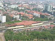
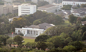
. It is characterized by many historic buildings from the colonial era. Gambir Subdistrict is the location of many political and administrative center of Jakarta and Indonesia. The Merdeka Palace (the presidential palace of Indonesia), the National Museum and the Merdeka Square
Merdeka Square, Jakarta
Merdeka Square is a large square located in the center of Jakarta, Indonesia. The square is surrounded by important government buildings such as the Merdeka Palace, the Supreme Court and various governmental ministries. At its center stands the National Monument...
(the location of the National Monument) are located in Gambir.
Gambir is bounded by the Flood Canal to the west, the river Ciliwung to the east, KH Zainul Arifin and Sukarjo Wiryopranoto Road to the north, and Kebon Sirih Raya Road to the south.
The City Hall of Central Jakarta is located in Petojo Selatan, Gambir Subdistrict. One of the busiest railway station of Jakarta, Gambir Station
Gambir Station
Gambir Station is a mainline railway station in Gambir, Central Jakarta, Indonesia. It is located on eastern side of Merdeka Square. It was built by the colonial Dutch before World War II but renovated in the 1990s...
, is located in Gambir, Gambir Subdistrict.
Toponym
The name Gambir is taken from the name of a French-decent Dutch lieutenant named Gambier, the lieutenant whom Daendels assigned to pave the way to the south.History
The area that is now Gambir Subdistrict was originally a southern hinterland of BataviaJakarta Old Town
Kota , is a small area in Jakarta, Indonesia. It is also known as Old Jakarta, and Old Batavia . It spans 1.3 square kilometres of North Jakarta and West Jakarta...
with marshes and known for the gambier plant
Uncaria
Uncaria is a genus of flowering plants in the family Rubiaceae. It has about 40 species. Their distribution is pantropical, with most species native to tropical Asia, three from Africa and the Mediterranean and two from the neotropics. They are known colloquially as Gambier, Cat's Claw or Uña de...
. A kampung settlement existed under the name Kampung Gambir. In the 18th century, a landowner known as Anthony Paviljoen began to developed the area and later rented them to Chinese people who further developed the land as an agricultural land.
When Batavia moved to the south, the Gambir area was subsequently developed. This new development was centered around a large field known as the Merdeka Square
Merdeka Square, Jakarta
Merdeka Square is a large square located in the center of Jakarta, Indonesia. The square is surrounded by important government buildings such as the Merdeka Palace, the Supreme Court and various governmental ministries. At its center stands the National Monument...
. This open field was known as Champ de Mars in 1808 and Koningsplein in 1816. During the governmency of Daendels, the center of administration was moved from the old Batavia to Gambir area, centered in Weltevreden. The area around the large field was characteristically surrounded with colonial buildings, mansions, and other civic facilities. Some of these buildings are restored and has become landmarks of Jakarta, such as the Willemskerk (now the Immanuel Church) and The Batavian Society of Arts and Science (now the National Museum).
Kelurahan (Administrative Villages)
The subdistrict of Gambir is divided into six kelurahanVillage (Indonesia)
An administrative village is the lowest level of government administration in Indonesia. It could be a village or a kelurahan. A village is headed by a village chief , which is elected by popular vote. A kelurahan is headed by a lurah....
or administrative villages:
- Gambir - area code 10110
- Kebon Kelapa - area code 10120
- Petojo Selatan - area code 10130
- Duri Pulo - area code 10140
- Cideng - area code 10150
- Petojo Utara - area code 10160
List of important places

- City Hall of Central Jakarta
- Gambir StationGambir StationGambir Station is a mainline railway station in Gambir, Central Jakarta, Indonesia. It is located on eastern side of Merdeka Square. It was built by the colonial Dutch before World War II but renovated in the 1990s...
- Governor Office of DKI Jakarta
- Immanuel Church
- Merdeka Palace
- Merdeka SquareMerdeka Square, JakartaMerdeka Square is a large square located in the center of Jakarta, Indonesia. The square is surrounded by important government buildings such as the Merdeka Palace, the Supreme Court and various governmental ministries. At its center stands the National Monument...
- Monas
- National Gallery
- National Museum
- Taman Prasasti MuseumTaman Prasasti MuseumTaman Prasasti Museum or Museum of Memorial Stone Park is a museum located in Jakarta, Indonesia. The museum was formerly a cemetery, built by the Dutch colonial government in 1795 as a final resting place for noble Dutchmen...

