

Frisland
Encyclopedia
Phantom island
Phantom islands are islands that were believed to exist, and appeared on maps for a period of time during recorded history, but were later removed after they were proved to be nonexistent...
that appeared on virtually all of the maps of the North Atlantic from the 1560s
1560s
-Births:* Galileo Galilei, Italian physicist, mathematician, astronomer, and philosopher* William Shakespeare, English playwright* Edward Wright , English mathematician and cartographer...
through the 1660s. It is not to be confused with the similarly named Friesland
Friesland
Friesland is a province in the north of the Netherlands and part of the ancient region of Frisia.Until the end of 1996, the province bore Friesland as its official name. In 1997 this Dutch name lost its official status to the Frisian Fryslân...
.
It originally referred to Iceland
Iceland
Iceland , described as the Republic of Iceland, is a Nordic and European island country in the North Atlantic Ocean, on the Mid-Atlantic Ridge. Iceland also refers to the main island of the country, which contains almost all the population and almost all the land area. The country has a population...
("Freezeland"), but after the Zeno Map
Zeno map
The Zeno map is a map of the North Atlantic first published in 1558 in Venice by Nicolo Zeno, a descendant of Nicolo Zeno, of the Zeno brothers....
(1558) placed it as an entirely separate island south (or occasionally south-west) of Iceland, it appeared that way on maps for the next 100 years. Its existence was given currency in manuscript maps of the 1560s by the Maggiolo family of Genoa and was accepted by Mercator and Jodocus Hondius
Jodocus Hondius
Jodocus Hondius , sometimes called Jodocus Hondius the Elder to distinguish him from his son Henricus Hondius II, was a Flemish artist, engraver, and cartographer...
. Some early maps by Willem Blaeu
Willem Blaeu
Willem Janszoon Blaeu , also abbreviated to Willem Jansz. Blaeu, was a Dutch cartographer, atlas maker and publisher....
, such as his 1617 map of Europe, omit it, but it reappears on his 1630 world map as one of many islands shown off the eastern coast of Labrador
Labrador
Labrador is the distinct, northerly region of the Canadian province of Newfoundland and Labrador. It comprises the mainland portion of the province, separated from the island of Newfoundland by the Strait of Belle Isle...
which was then believed to extend to within a few hundred miles of Scotland. Among its last appearances is in a 1652 world map by Visscher, largely copied from that of Blaeu.
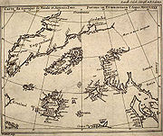
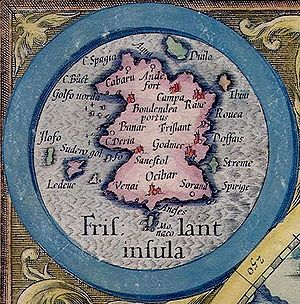
Frisland was shown as a roughly rectangular island with three triangular promontories on its western coast. Its place-names have a very Italian look (Aqua, Spagia, Bondendea, Monaco), a fact which seems to reinforce the suspicion that its details were fabricated in southern Europe.
Frisland eventually came to be identified with the Faroe Islands
Faroe Islands
The Faroe Islands are an island group situated between the Norwegian Sea and the North Atlantic Ocean, approximately halfway between Scotland and Iceland. The Faroe Islands are a self-governing territory within the Kingdom of Denmark, along with Denmark proper and Greenland...
. However, Frisland and the Faroe Islands both appear on several maps, many hundreds of miles apart.
Frisland appears to be born out of confusion between an imaginary island and the actual southern part of Greenland
Greenland
Greenland is an autonomous country within the Kingdom of Denmark, located between the Arctic and Atlantic Oceans, east of the Canadian Arctic Archipelago. Though physiographically a part of the continent of North America, Greenland has been politically and culturally associated with Europe for...
. Even in the mid 18th century, explorers' maps clearly depicted Frisland as separated from Greenland by a wide strait.
The myth of Frisland was exposed as explorers, chiefly from England and France, charted and mapped the north-west waters.