

Fremington Edge
Encyclopedia
Scree
Scree, also called talus, is a term given to an accumulation of broken rock fragments at the base of crags, mountain cliffs, or valley shoulders. Landforms associated with these materials are sometimes called scree slopes or talus piles...
slopes that is situated to the north of the village of Reeth
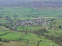
Reeth
Reeth is a village in the Yorkshire Dales within the Richmondshire district of North Yorkshire, England and principal settlement of Swaledale. It is situated at the meeting point of the two most northerly of the Yorkshire Dales: Swaledale and Arkengarthdale....
in Swaledale
Swaledale
Swaledale is one of the northernmost dales in the Yorkshire Dales National Park in northern England. It is the dale of the River Swale on the east side of the Pennines in North Yorkshire.-Geographical overview:...
in the Yorkshire Dales National Park
Yorkshire Dales
The Yorkshire Dales is the name given to an upland area in Northern England.The area lies within the historic county boundaries of Yorkshire, though it spans the ceremonial counties of North Yorkshire, West Yorkshire and Cumbria...
, England
England
England is a country that is part of the United Kingdom. It shares land borders with Scotland to the north and Wales to the west; the Irish Sea is to the north west, the Celtic Sea to the south west, with the North Sea to the east and the English Channel to the south separating it from continental...
. Fremington Edge stands where the dales of Arkengarthdale
Arkengarthdale
Arkengarthdale is a dale, or valley, on the east side of the Pennines in North Yorkshire, England. Running roughly northwest–southeast, it is the valley of the Arkle Beck, and is the northernmost of the Yorkshire Dales...
and Swaledale meet. Throughout its full length the Edge stays above the height of 400 metres and reaches a highest point of 473 metres (1552 feet) at the northern end of the escarpment.
Fremington Edge was formed after the last Ice age
Ice age
An ice age or, more precisely, glacial age, is a generic geological period of long-term reduction in the temperature of the Earth's surface and atmosphere, resulting in the presence or expansion of continental ice sheets, polar ice sheets and alpine glaciers...
when melt water from the retreating glacier
Glacier
A glacier is a large persistent body of ice that forms where the accumulation of snow exceeds its ablation over many years, often centuries. At least 0.1 km² in area and 50 m thick, but often much larger, a glacier slowly deforms and flows due to stresses induced by its weight...
s caused a landslip and exposed the rocky outcrops. The Edge is scattered with remains of old Lead
Lead
Lead is a main-group element in the carbon group with the symbol Pb and atomic number 82. Lead is a soft, malleable poor metal. It is also counted as one of the heavy metals. Metallic lead has a bluish-white color after being freshly cut, but it soon tarnishes to a dull grayish color when exposed...
mines and there are many disused shafts and spoil heaps. Some of these old workings are dangerous and care should be taken. A footpath and a solid dry stone wall stretch the entire length of the Edge with the heather clad Marrick Moor extending away to the east. Midway along is a disused television mast
The Edge can be climbed either from Reeth, Langthwaite or Fremington. The ascent from Langthwaite goes by an old lane past the hamlet of Booze and the old farmhouse of Storthwaite Hall before winding steeply up through the disused workings of the Fell End Lead Mine to reach the highest point. The climb from Fremington utilises the well graded old road (now just a stony track) to Hurst, which passes the whitewashed farmhouse of the White House, a well seen landmark from Reeth. The climb from the popular tourist village of Reeth is quite hard going: a path goes directly up the steep escarpment from Arkle Beck to reach the Edge.
The view from the summit cairn at the northern end of the Edge gives an excellent view of Arkengarthdale, with Calver Hill
Calver Hill
Calver Hill is a fell in the Yorkshire Dales National Park in North Yorkshire, England. It composed of limestone and is situated at grid reference , near where the valleys of Swaledale and Arkengarthdale meet, the village of Reeth is located on its lower south eastern slopes, it reaches an altitude...
also well seen. The southern end of the Edge gives an impressive aerial view of the village of Reeth.