

Franklinton, Columbus, Ohio
Encyclopedia

Columbus, Ohio
Columbus is the capital of and the largest city in the U.S. state of Ohio. The broader metropolitan area encompasses several counties and is the third largest in Ohio behind those of Cleveland and Cincinnati. Columbus is the third largest city in the American Midwest, and the fifteenth largest city...
, Ohio
Ohio
Ohio is a Midwestern state in the United States. The 34th largest state by area in the U.S.,it is the 7th‑most populous with over 11.5 million residents, containing several major American cities and seven metropolitan areas with populations of 500,000 or more.The state's capital is Columbus...
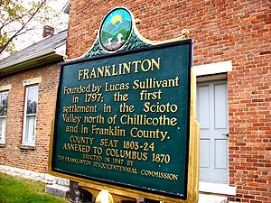
. Lucas Sullivant, a Virginia born land surveyor, established Franklinton in 1797. It is bordered by the Scioto River
Scioto River
The Scioto River is a river in central and southern Ohio more than 231 miles in length. It rises in Auglaize County in west central Ohio, flows through Columbus, Ohio, where it collects its largest tributary, the Olentangy River, and meets the Ohio River at Portsmouth...
on the north and east, Harmon Avenue on the east, Stimmel Road and Greenlawn Avenue on the south, and Interstate 70 on the west. West Broad Street, or US 40
U.S. Route 40
U.S. Route 40 is an east–west United States highway. As with most routes whose numbers end in a zero, U.S. 40 once traversed the entire United States. It is one of the original 1920s U.S. Highways, and its first termini were San Francisco, California, and Atlantic City, New Jersey...
, is one of the country's first roads and is Franklinton's main throughway.
Franklinton is the neighborhood immediately west of downtown. It gets its colorful nickname of "The Bottoms
The Bottoms
The Bottoms is a neighborhood in Columbus, Ohio, U.S. It is the area immediately west of Downtown Columbus. The area contains the Franklinton neighborhood, and is in West Columbus. It is the area enclosed by I-70 on the west and south, I-670 on the north, and the Scioto River to the east...
" because much of the land lies below the level of the Scioto and Olentangy rivers, and a floodwall is required to contain the rivers and protect the area from devastating floods. The fertile, low-lying bottom land was ideal for farming, with the river serving as a direct connection to the Ohio River
Ohio River
The Ohio River is the largest tributary, by volume, of the Mississippi River. At the confluence, the Ohio is even bigger than the Mississippi and, thus, is hydrologically the main stream of the whole river system, including the Allegheny River further upstream...
and beyond. (Just to the west of Franklinton is a group of smaller neighborhoods commonly referred to as "The Hilltop
Hilltop, Columbus, Ohio
Hilltop USA is a geographic area of Columbus, Ohio on the west side of the city. It was so named because it sits atop a rise that slopes down into the Scioto River. , Wilshire Heights and Westgate are included within the Greater Hilltop area. It borders on Franklinton...
.") More recently, "The Bottoms
The Bottoms
The Bottoms is a neighborhood in Columbus, Ohio, U.S. It is the area immediately west of Downtown Columbus. The area contains the Franklinton neighborhood, and is in West Columbus. It is the area enclosed by I-70 on the west and south, I-670 on the north, and the Scioto River to the east...
" has been applied to describe the low socioeconomic status and comparatively high crime rate of the area.
According to the Franklinton Area Commission:
- Though Franklinton is the last downtown neighborhood to be redeveloped, it is actually the birth place of Columbus, settled 15 years before the city itself.
- Franklinton was once a separate city from Columbus, like the present-day cities of BexleyBexley, OhioBexley is an affluent suburban city in Franklin County, Ohio. Founded as a village over a hundred years ago, the City of Bexley is an old, tree-lined suburb of Columbus, the state capital of Ohio, situated on the banks of Alum Creek next to Driving Park and Wolfe Park, just east of the Franklin...
and WhitehallWhitehall, OhioAs of the census of 2000, there were 19,201 people, 8,343 households, and 4,930 families residing in the city. The population density was 3,681.9 people per square mile . There were 8,997 housing units at an average density of 1,725.2 per square mile...
, which are both completely surrounded by the city of Columbus, but continue to exist as separate municipalities.
- Since the completion of the floodwall, the community redevelopment has included more than 40 residential projects, a new firehouse, two new schools, new residential dorms at Mount Carmel Medical Center West and the exploration of countless commercial projects.
- This neighborhood has easy access to all of Columbus' major highways.
- The neighborhood is a recovering flood area.