
Fouras
Encyclopedia
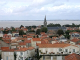
Fouras is a commune
in the Charente-Maritime
department in the Poitou-Charentes
region
in southwestern France
. It lies 34 km south of La Rochelle
.
 Fouras is on a peninsula
. It is bordered by five beach
es and a forest named "Bois Vert" ("Green Wood" in English) which covers 20% of its area.
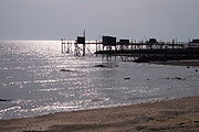
It extends into a roadway to discover tide
to the low Fort Enet
in the direction of the Île-d'Aix
. The pier for the island of Aix is also located in the territory of the commune.
The south coast of the peninsula
of Fouras forms the northern side of the mouth of the Charente river
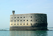
. A little further south is the Île d'Oléron. Off the island between Aix and the island of Oleron is the Fort Boyard
, which was made famous by the French issuance of the same name: "Père Fouras" is not for nothing in the Fouras' celebrity .
. The donjon received a signal station from 1889 to World War II
.
Communes of France
The commune is the lowest level of administrative division in the French Republic. French communes are roughly equivalent to incorporated municipalities or villages in the United States or Gemeinden in Germany...
in the Charente-Maritime
Charente-Maritime
Charente-Maritime is a department on the west coast of France named after the Charente River.- History :Previously a part of Saintonge, Charente-Inférieure was one of the 83 original departments created during the French Revolution on 4 March 1790...
department in the Poitou-Charentes
Poitou-Charentes
Poitou-Charentes is an administrative region in central western France comprising four departments: Charente, Charente-Maritime, Deux-Sèvres and Vienne. The regional capital is Poitiers.-Politics:The regional council is composed of 56 members...
region
Régions of France
France is divided into 27 administrative regions , 22 of which are in Metropolitan France, and five of which are overseas. Corsica is a territorial collectivity , but is considered a region in mainstream usage, and is even shown as such on the INSEE website...
in southwestern France
France
The French Republic , The French Republic , The French Republic , (commonly known as France , is a unitary semi-presidential republic in Western Europe with several overseas territories and islands located on other continents and in the Indian, Pacific, and Atlantic oceans. Metropolitan France...
. It lies 34 km south of La Rochelle
La Rochelle
La Rochelle is a city in western France and a seaport on the Bay of Biscay, a part of the Atlantic Ocean. It is the capital of the Charente-Maritime department.The city is connected to the Île de Ré by a bridge completed on 19 May 1988...
.
Geography
Peninsula
A peninsula is a piece of land that is bordered by water on three sides but connected to mainland. In many Germanic and Celtic languages and also in Baltic, Slavic and Hungarian, peninsulas are called "half-islands"....
. It is bordered by five beach
Beach
A beach is a geological landform along the shoreline of an ocean, sea, lake or river. It usually consists of loose particles which are often composed of rock, such as sand, gravel, shingle, pebbles or cobblestones...
es and a forest named "Bois Vert" ("Green Wood" in English) which covers 20% of its area.
It extends into a roadway to discover tide
Tide
Tides are the rise and fall of sea levels caused by the combined effects of the gravitational forces exerted by the moon and the sun and the rotation of the Earth....
to the low Fort Enet
Fort Enet
Fort Énet is a fortification in the Pertuis d'Antioche in Charente-Maritime, France. It is located on the "Pointe de la Fumée", the roadway extending from the city of Fouras, between Fouras and Île-d'Aix, and can be accessed from there at low tide....
in the direction of the Île-d'Aix
Île-d'Aix
Île-d'Aix is a commune in the Charente-Maritime department off the west coast of France. It occupies the territory of small island of Île d'Aix in the Atlantic. It is a popular place for tourist day-trips during the summer months.-Location:...
. The pier for the island of Aix is also located in the territory of the commune.
The south coast of the peninsula
Peninsula
A peninsula is a piece of land that is bordered by water on three sides but connected to mainland. In many Germanic and Celtic languages and also in Baltic, Slavic and Hungarian, peninsulas are called "half-islands"....
of Fouras forms the northern side of the mouth of the Charente river
Charente River
The Charente is a 381 km long river in southwestern France.Its source is in the Haute-Vienne département at Chéronnac, a small village near Rochechouart. It flows through the departments of Haute-Vienne, Charente, Vienne and Charente-Maritime...
. A little further south is the Île d'Oléron. Off the island between Aix and the island of Oleron is the Fort Boyard
Fort Boyard
Fort Boyard is a fort located between the Île-d'Aix and the Île d'Oléron in the Pertuis d'Antioche straits, on the west coast of France. Though a fort on Boyard bank was suggested as early as the 17th century, it was not until the 1800s under Napoleon Bonaparte that work began.-Layout:Fort...
, which was made famous by the French issuance of the same name: "Père Fouras" is not for nothing in the Fouras' celebrity .
Population
Vauban fortress
The "Vauban fortress" was initially a strategic fortification established by Philippe le Bel, circa 1300. The donjon was rebuilt in 1480-1490 by Jehan II de Brosse. In 1689, Ferry reinforced the walls of the Donjon to set up a battery of 9 canons and a signaling point. In 1693 a lower a circular battery was set up to control access to the Charente RiverCharente River
The Charente is a 381 km long river in southwestern France.Its source is in the Haute-Vienne département at Chéronnac, a small village near Rochechouart. It flows through the departments of Haute-Vienne, Charente, Vienne and Charente-Maritime...
. The donjon received a signal station from 1889 to World War II
World War II
World War II, or the Second World War , was a global conflict lasting from 1939 to 1945, involving most of the world's nations—including all of the great powers—eventually forming two opposing military alliances: the Allies and the Axis...
.