
Fort Proctor
Encyclopedia
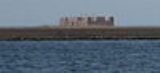
Fort Proctor is a ruined 19th century fort in St. Bernard Parish, Louisiana
. Also known as Fort Beauregard or Beauregard's Castle (after P.G.T. Beauregard, who supervised its construction with architect J.G. Totten) is located on the shore of Lake Borgne
just north of the mouth of Bayou Yscolskey. At the time it was built in the 1850s, there was also a railroad port called "Proctorville" adjacent.
The fort was intended to be part of the fortification protecting water routes towards New Orleans, Louisiana
. Due to delays caused by hurricane damage, and then the outbreak of the American Civil War
, the fort was never garrisoned, and by the end of the war improvements in artillery
had made the fort design obsolete.
In the 1940's and 50's, before it was engulfed by the lake, the ruins of the fort became a somewhat popular gathering spot for high school aged children seeking a spot where they could not be supervised.
The construction of the Mississippi River-Gulf Outlet Canal
in the 1960s cut off all land access to the fort site. It can be seen in the distance from Shell Beach, Louisiana. In 1978 it was listed on the National Register of Historic Places
. It is now completely surrounded by water about one foot deep. There remained one small piece of dry land inside of the fort, and after Hurricane Katrina
, very little of that one dry spot is still dry.
St. Bernard Parish, Louisiana
St. Bernard Parish is a parish located southeast of New Orleans in the U.S. state of Louisiana. The parish seat is Chalmette, the largest city in the parish. As of 2000, its population was 67,229. It has been ranked the fastest-growing county in the United States from 2007 to 2008 by the U.S....
. Also known as Fort Beauregard or Beauregard's Castle (after P.G.T. Beauregard, who supervised its construction with architect J.G. Totten) is located on the shore of Lake Borgne
Lake Borgne
Lake Borgne is a lagoon in eastern Louisiana of the Gulf of Mexico. Due to coastal erosion, it is no longer actually a lake but rather an arm of the Gulf of Mexico. Its name comes from the French word borgne, which means "one-eyed".-Geography:...
just north of the mouth of Bayou Yscolskey. At the time it was built in the 1850s, there was also a railroad port called "Proctorville" adjacent.
The fort was intended to be part of the fortification protecting water routes towards New Orleans, Louisiana
New Orleans, Louisiana
New Orleans is a major United States port and the largest city and metropolitan area in the state of Louisiana. The New Orleans metropolitan area has a population of 1,235,650 as of 2009, the 46th largest in the USA. The New Orleans – Metairie – Bogalusa combined statistical area has a population...
. Due to delays caused by hurricane damage, and then the outbreak of the American Civil War
American Civil War
The American Civil War was a civil war fought in the United States of America. In response to the election of Abraham Lincoln as President of the United States, 11 southern slave states declared their secession from the United States and formed the Confederate States of America ; the other 25...
, the fort was never garrisoned, and by the end of the war improvements in artillery
Artillery
Originally applied to any group of infantry primarily armed with projectile weapons, artillery has over time become limited in meaning to refer only to those engines of war that operate by projection of munitions far beyond the range of effect of personal weapons...
had made the fort design obsolete.
In the 1940's and 50's, before it was engulfed by the lake, the ruins of the fort became a somewhat popular gathering spot for high school aged children seeking a spot where they could not be supervised.
The construction of the Mississippi River-Gulf Outlet Canal
Mississippi River-Gulf Outlet Canal
The Mississippi River – Gulf Outlet Canal is a channel constructed by the United States Army Corps of Engineers in the mid-20th century that provided a shorter route between the Gulf of Mexico and New Orleans' inner harbor Industrial Canal via the Intracoastal Waterway...
in the 1960s cut off all land access to the fort site. It can be seen in the distance from Shell Beach, Louisiana. In 1978 it was listed on the National Register of Historic Places
National Register of Historic Places
The National Register of Historic Places is the United States government's official list of districts, sites, buildings, structures, and objects deemed worthy of preservation...
. It is now completely surrounded by water about one foot deep. There remained one small piece of dry land inside of the fort, and after Hurricane Katrina
Hurricane Katrina
Hurricane Katrina of the 2005 Atlantic hurricane season was a powerful Atlantic hurricane. It is the costliest natural disaster, as well as one of the five deadliest hurricanes, in the history of the United States. Among recorded Atlantic hurricanes, it was the sixth strongest overall...
, very little of that one dry spot is still dry.