

Florida State Road 867
Encyclopedia
State Road 867 and Lee County Road 867 together create a 14.5 miles (23.3 km) roadway in Lee County, Florida
, connecting Punta Rassa
and Fort Myers, Florida
. The entire stretch used to be a State Road, but the southernmost 4.5 miles (7.2 km) have been redesignated County Road 867. Both SR 867 and CR 867 are known as McGregor Boulevard.
between Fort Myers
and Iona
. The northern terminus is in Downtown Fort Myers
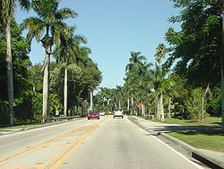
at an intersection with US 41 (Cleveland Avenue). The road continues eastward as State Road 82 (Dr. Martin Luther King Jr. Boulevard). Along the side of McGregor Boulevard, there are palm trees planted alongside the road. These palm trees are the reason Fort Myers is nicknamed "The City of Palms."
 SR 867 then travels southward, away from Downtown Fort Myers
, and intersects County Road 884 (Colonial Boulevard), which passes above on an overpass
connecting to the Midpoint Memorial Bridge
.
SR 867 then leaves Fort Myers
city limits and enters McGregor
, a Fort Myers suburb that makes up part of South Fort Myers
. It then intersects with College Parkway and Cape Coral Bridge Road (CR 867A). Cape Coral Bridge Road travels west into Cape Coral
via the Cape Coral Bridge
, while College Parkway travels eastward into Fort Myers
. The intersection with College Parkway and Cape Coral Bridge Road features a Single-Point Urban Interchange
, with College Parkway/Cape Coral Bridge Road crossing above on an overpass
.
SR 867 then intersects County Road 876 (Cypress Lake Drive) which travels east into Cypress Lake
. SR 867 then turns southwest, leaves McGregor
, and enters Iona
, another Fort Myers suburb. SR 867's southern terminus is located within Iona at an intersection with San Carlos Boulevard (SR 865) and Gladiolus Drive (CR 865). McGregor Boulevard continues to the west as County Road 867 from this point.
, the road was known as State Road 25, and in the reassignment, the portion from US 41 in Fort Myers east to Palm Beach was transferred over to the new SR 80
, with the sections of old SR 25 west of US 41 reassigned to SR 867.
and Punta Rassa
. CR 867 mostly travels at an east–west trajectory, despite the fact that is signed as a north–south route. CR 867 travels west from its northern terminus and continues through Iona
. CR 867 intersects Summerlin Road (CR 869) (which terminates at CR 867).
CR 867 turns right and continues west (continuing the route of Summerlin Road), passing Port Sanibel and Connie Mack Island. CR 867 continues towards the west coast of Florida
and terminates in Punta Rassa
at Punta Rassa Road. Here, the road continues as Causeway Boulevard, and travels onto Sanibel Island
via the Sanibel Causeway
, which crosses the San Carlos Bay. When CR 867 was part of SR 867, SR 867 continued onto Sanibel Island
. However, CR 867 terminates at Punta Rassa Road, and Causeway Boulevard does not have a route number anymore.
. It was formerly a state highway
known as State Road 867A.
The southern terminus of CR 867A is at an intersection with McGregor Boulevard (SR 867) in Fort Myers
. From the southern terminus of CR 867A, the route continues 2.5 miles (4 km) east to US 41 (S. Cleveland Avenue) and is known as College Parkway. From here, CR 867A is known as Cape Coral Bridge Road, and it travels west and crosses the Caloosahatchee River
via the Cape Coral Bridge
into Cape Coral, Florida
.
At the west side of the Cape Coral Bridge
, CR 867A becomes Cape Coral Parkway. It follows Cape Coral Parkway for only 0.7 miles (1.1 km) until an intersection with Del Prado Boulevard. From here, CR 867A turns north and follows Del Prado Boulevard. Del Prado Boulevard continues north through most of Cape Coral, Florida
and intersects Veterans Parkway (CR 884), which is a grade-separated SPUI Interchange
, with Veterans Parkway passing over on an overpass
. Veterans Parkway is one of Cape Coral's
major east–west routes, and it travels into Fort Myers
via the Midpoint Memorial Bridge
. Del Prado Boulevard continues northward until its northern terminus at Pine Island Road (SR 78).
Del Prado Boulevard extends five miles (8 km) northward from Pine Island Road to an intersection with US 41 (North Tamiami Trail
) at the northern Cape Coral city limits. This northern section was formerly part of State Road 867A, but not part of the current County Road.
Lee County, Florida
Lee County is a county located in the U.S. state of Florida. Located in southwest Florida, the principal cities in the county are Fort Myers and Cape Coral...
, connecting Punta Rassa
Punta Rassa, Florida
Punta Rassa is a census-designated place in Lee County, Florida, United States. The population was 1,750 at the 2010 census. It is part of the Cape Coral–Fort Myers Metropolitan Statistical Area.-Geography:...
and Fort Myers, Florida
Fort Myers, Florida
Fort Myers is the county seat and commercial center of Lee County, Florida, United States. Its population was 62,298 in the 2010 census, a 29.23 percent increase over the 2000 figure....
. The entire stretch used to be a State Road, but the southernmost 4.5 miles (7.2 km) have been redesignated County Road 867. Both SR 867 and CR 867 are known as McGregor Boulevard.
Route description
The current State Road 867 is a 10-mile-long street paralleling the Caloosahatchee RiverCaloosahatchee River
The Caloosahatchee River is a river on the southwest Gulf Coast of Florida in the United States, approximately long. It drains rural areas on the northern edge of the Everglades northwest of Miami...
between Fort Myers
Fort Myers, Florida
Fort Myers is the county seat and commercial center of Lee County, Florida, United States. Its population was 62,298 in the 2010 census, a 29.23 percent increase over the 2000 figure....
and Iona
Iona, Florida
Iona is a census-designated place in Lee County, Florida, United States. The population was 11,756 at the 2000 census. It is part of the Cape Coral–Fort Myers Metropolitan Statistical Area.-Geography:Iona is located at ....
. The northern terminus is in Downtown Fort Myers
Fort Myers, Florida
Fort Myers is the county seat and commercial center of Lee County, Florida, United States. Its population was 62,298 in the 2010 census, a 29.23 percent increase over the 2000 figure....
at an intersection with US 41 (Cleveland Avenue). The road continues eastward as State Road 82 (Dr. Martin Luther King Jr. Boulevard). Along the side of McGregor Boulevard, there are palm trees planted alongside the road. These palm trees are the reason Fort Myers is nicknamed "The City of Palms."
Fort Myers, Florida
Fort Myers is the county seat and commercial center of Lee County, Florida, United States. Its population was 62,298 in the 2010 census, a 29.23 percent increase over the 2000 figure....
, and intersects County Road 884 (Colonial Boulevard), which passes above on an overpass
Overpass
An overpass is a bridge, road, railway or similar structure that crosses over another road or railway...
connecting to the Midpoint Memorial Bridge
Midpoint Memorial Bridge
The Midpoint Memorial Bridge is a bridge located in Southwest Florida. It spans the Caloosahatchee River, connecting Fort Myers and Cape Coral. It is a four-lane fixed span one and one-quarter mile long...
.
SR 867 then leaves Fort Myers
Fort Myers, Florida
Fort Myers is the county seat and commercial center of Lee County, Florida, United States. Its population was 62,298 in the 2010 census, a 29.23 percent increase over the 2000 figure....
city limits and enters McGregor
McGregor, Florida
McGregor is a census-designated place in Lee County, Florida, United States. The population was 7,136 at the 2000 census. It is part of the Cape Coral–Fort Myers Metropolitan Statistical Area.-Geography:...
, a Fort Myers suburb that makes up part of South Fort Myers
South Fort Myers, Florida
South Fort Myers is an unincorporated area of Lee County, Florida, United States. According to the U.S. Census Bureau, in 2000 the area had a population of 49,912....
. It then intersects with College Parkway and Cape Coral Bridge Road (CR 867A). Cape Coral Bridge Road travels west into Cape Coral
Cape Coral, Florida
Cape Coral is a municipality located in Lee County, Florida, United States, on the Gulf of Mexico. Founded in 1957 and developed as a master-planned, pre-platted community, the city grew to a population of 154,305 by the year 2010. With an area of , Cape Coral is the largest city between Tampa and...
via the Cape Coral Bridge
Cape Coral Bridge
The Cape Coral Bridge is a bridge located in Southwest Florida. It spans the Caloosahatchee River connecting Fort Myers and Cape Coral. It is made up of two parallel fixed spans, each long....
, while College Parkway travels eastward into Fort Myers
Fort Myers, Florida
Fort Myers is the county seat and commercial center of Lee County, Florida, United States. Its population was 62,298 in the 2010 census, a 29.23 percent increase over the 2000 figure....
. The intersection with College Parkway and Cape Coral Bridge Road features a Single-Point Urban Interchange
Single-point urban interchange
A single-point urban interchange , also called a single-point interchange or single-point diamond interchange , is a type of highway interchange...
, with College Parkway/Cape Coral Bridge Road crossing above on an overpass
Overpass
An overpass is a bridge, road, railway or similar structure that crosses over another road or railway...
.
SR 867 then intersects County Road 876 (Cypress Lake Drive) which travels east into Cypress Lake
Cypress Lake, Florida
Cypress Lake is a census-designated place in Lee County, Florida, United States. The population was 12,072 at the 2000 census. It is part of the Cape Coral–Fort Myers Metropolitan Statistical Area.-Geography:...
. SR 867 then turns southwest, leaves McGregor
McGregor, Florida
McGregor is a census-designated place in Lee County, Florida, United States. The population was 7,136 at the 2000 census. It is part of the Cape Coral–Fort Myers Metropolitan Statistical Area.-Geography:...
, and enters Iona
Iona, Florida
Iona is a census-designated place in Lee County, Florida, United States. The population was 11,756 at the 2000 census. It is part of the Cape Coral–Fort Myers Metropolitan Statistical Area.-Geography:Iona is located at ....
, another Fort Myers suburb. SR 867's southern terminus is located within Iona at an intersection with San Carlos Boulevard (SR 865) and Gladiolus Drive (CR 865). McGregor Boulevard continues to the west as County Road 867 from this point.
History
From 1923 to the 1945 renumbering1945 Florida State Road renumbering
On June 11, 1945, Florida's state roads were renumbered. The old system numbered routes in the order they were legislated, while the new system used a grid.For more detailed information on where each road was, go to the corresponding page.-See also:...
, the road was known as State Road 25, and in the reassignment, the portion from US 41 in Fort Myers east to Palm Beach was transferred over to the new SR 80
Florida State Road 80
Florida State Road 80 is a route linking US 41 in Fort Myers and Florida State Road A1A in Palm Beach. The road is the northernmost of three linking Southwest Florida to South Florida via the Everglades...
, with the sections of old SR 25 west of US 41 reassigned to SR 867.
Lee County Road 867
County Road 867 continues from where State Road 867 left off, connecting IonaIona, Florida
Iona is a census-designated place in Lee County, Florida, United States. The population was 11,756 at the 2000 census. It is part of the Cape Coral–Fort Myers Metropolitan Statistical Area.-Geography:Iona is located at ....
and Punta Rassa
Punta Rassa, Florida
Punta Rassa is a census-designated place in Lee County, Florida, United States. The population was 1,750 at the 2010 census. It is part of the Cape Coral–Fort Myers Metropolitan Statistical Area.-Geography:...
. CR 867 mostly travels at an east–west trajectory, despite the fact that is signed as a north–south route. CR 867 travels west from its northern terminus and continues through Iona
Iona, Florida
Iona is a census-designated place in Lee County, Florida, United States. The population was 11,756 at the 2000 census. It is part of the Cape Coral–Fort Myers Metropolitan Statistical Area.-Geography:Iona is located at ....
. CR 867 intersects Summerlin Road (CR 869) (which terminates at CR 867).
CR 867 turns right and continues west (continuing the route of Summerlin Road), passing Port Sanibel and Connie Mack Island. CR 867 continues towards the west coast of Florida
Florida
Florida is a state in the southeastern United States, located on the nation's Atlantic and Gulf coasts. It is bordered to the west by the Gulf of Mexico, to the north by Alabama and Georgia and to the east by the Atlantic Ocean. With a population of 18,801,310 as measured by the 2010 census, it...
and terminates in Punta Rassa
Punta Rassa, Florida
Punta Rassa is a census-designated place in Lee County, Florida, United States. The population was 1,750 at the 2010 census. It is part of the Cape Coral–Fort Myers Metropolitan Statistical Area.-Geography:...
at Punta Rassa Road. Here, the road continues as Causeway Boulevard, and travels onto Sanibel Island
Sanibel Island
Sanibel Island is an island located on the Gulf coast of Florida, just offshore of Fort Myers. In 2000, it had an estimated population of 6,064 people...
via the Sanibel Causeway
Sanibel Causeway
The Sanibel Causeway is a causeway in Southwest Florida that spans the San Carlos Bay, connecting Sanibel Island with the Florida mainland in South Fort Myers. The causeway consists of three separate two-lane bridge spans, and two man-made causeway islands, which are located between each of the...
, which crosses the San Carlos Bay. When CR 867 was part of SR 867, SR 867 continued onto Sanibel Island
Sanibel Island
Sanibel Island is an island located on the Gulf coast of Florida, just offshore of Fort Myers. In 2000, it had an estimated population of 6,064 people...
. However, CR 867 terminates at Punta Rassa Road, and Causeway Boulevard does not have a route number anymore.
Lee County Road 867A
County Road 867A is the primary north–south arterial road for Cape Coral, FloridaCape Coral, Florida
Cape Coral is a municipality located in Lee County, Florida, United States, on the Gulf of Mexico. Founded in 1957 and developed as a master-planned, pre-platted community, the city grew to a population of 154,305 by the year 2010. With an area of , Cape Coral is the largest city between Tampa and...
. It was formerly a state highway
State highway
State highway, state road or state route can refer to one of three related concepts, two of them related to a state or provincial government in a country that is divided into states or provinces :#A...
known as State Road 867A.
The southern terminus of CR 867A is at an intersection with McGregor Boulevard (SR 867) in Fort Myers
Fort Myers, Florida
Fort Myers is the county seat and commercial center of Lee County, Florida, United States. Its population was 62,298 in the 2010 census, a 29.23 percent increase over the 2000 figure....
. From the southern terminus of CR 867A, the route continues 2.5 miles (4 km) east to US 41 (S. Cleveland Avenue) and is known as College Parkway. From here, CR 867A is known as Cape Coral Bridge Road, and it travels west and crosses the Caloosahatchee River
Caloosahatchee River
The Caloosahatchee River is a river on the southwest Gulf Coast of Florida in the United States, approximately long. It drains rural areas on the northern edge of the Everglades northwest of Miami...
via the Cape Coral Bridge
Cape Coral Bridge
The Cape Coral Bridge is a bridge located in Southwest Florida. It spans the Caloosahatchee River connecting Fort Myers and Cape Coral. It is made up of two parallel fixed spans, each long....
into Cape Coral, Florida
Cape Coral, Florida
Cape Coral is a municipality located in Lee County, Florida, United States, on the Gulf of Mexico. Founded in 1957 and developed as a master-planned, pre-platted community, the city grew to a population of 154,305 by the year 2010. With an area of , Cape Coral is the largest city between Tampa and...
.
At the west side of the Cape Coral Bridge
Cape Coral Bridge
The Cape Coral Bridge is a bridge located in Southwest Florida. It spans the Caloosahatchee River connecting Fort Myers and Cape Coral. It is made up of two parallel fixed spans, each long....
, CR 867A becomes Cape Coral Parkway. It follows Cape Coral Parkway for only 0.7 miles (1.1 km) until an intersection with Del Prado Boulevard. From here, CR 867A turns north and follows Del Prado Boulevard. Del Prado Boulevard continues north through most of Cape Coral, Florida
Cape Coral, Florida
Cape Coral is a municipality located in Lee County, Florida, United States, on the Gulf of Mexico. Founded in 1957 and developed as a master-planned, pre-platted community, the city grew to a population of 154,305 by the year 2010. With an area of , Cape Coral is the largest city between Tampa and...
and intersects Veterans Parkway (CR 884), which is a grade-separated SPUI Interchange
Single-point urban interchange
A single-point urban interchange , also called a single-point interchange or single-point diamond interchange , is a type of highway interchange...
, with Veterans Parkway passing over on an overpass
Overpass
An overpass is a bridge, road, railway or similar structure that crosses over another road or railway...
. Veterans Parkway is one of Cape Coral's
Cape Coral, Florida
Cape Coral is a municipality located in Lee County, Florida, United States, on the Gulf of Mexico. Founded in 1957 and developed as a master-planned, pre-platted community, the city grew to a population of 154,305 by the year 2010. With an area of , Cape Coral is the largest city between Tampa and...
major east–west routes, and it travels into Fort Myers
Fort Myers, Florida
Fort Myers is the county seat and commercial center of Lee County, Florida, United States. Its population was 62,298 in the 2010 census, a 29.23 percent increase over the 2000 figure....
via the Midpoint Memorial Bridge
Midpoint Memorial Bridge
The Midpoint Memorial Bridge is a bridge located in Southwest Florida. It spans the Caloosahatchee River, connecting Fort Myers and Cape Coral. It is a four-lane fixed span one and one-quarter mile long...
. Del Prado Boulevard continues northward until its northern terminus at Pine Island Road (SR 78).
Del Prado Boulevard extends five miles (8 km) northward from Pine Island Road to an intersection with US 41 (North Tamiami Trail
Tamiami Trail
The Tamiami Trail is the southernmost of U.S. Highway 41 from State Road 60 in Tampa to U.S. Route 1 in Miami. The road also has the hidden designation of State Road 90....
) at the northern Cape Coral city limits. This northern section was formerly part of State Road 867A, but not part of the current County Road.