
.gif)
Fiorina (San Marino)
Encyclopedia
| Fiorina | ||||
 |
||||
| Country Country A country is a region legally identified as a distinct entity in political geography. A country may be an independent sovereign state or one that is occupied by another state, as a non-sovereign or formerly sovereign political division, or a geographic region associated with a previously... : |
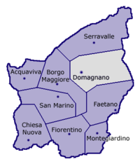
 San Marino San MarinoSan Marino San Marino, officially the Republic of San Marino , is a state situated on the Italian Peninsula on the eastern side of the Apennine Mountains. It is an enclave surrounded by Italy. Its size is just over with an estimated population of over 30,000. Its capital is the City of San Marino... |
|||
| Castle: |  Domagnano DomagnanoDomagnano Domagnano is a municipality in San Marino. It has 2,865 inhabitants in an area of 6.62 km².-Geography:It borders the San Marino municipalities Faetano, Borgo Maggiore, Serravalle and the Italian municipality Coriano.-History:... |
|||
| Population Population A population is all the organisms that both belong to the same group or species and live in the same geographical area. The area that is used to define a sexual population is such that inter-breeding is possible between any pair within the area and more probable than cross-breeding with individuals... : |
889 | |||
| Coordinates Geographic coordinate system A geographic coordinate system is a coordinate system that enables every location on the Earth to be specified by a set of numbers. The coordinates are often chosen such that one of the numbers represent vertical position, and two or three of the numbers represent horizontal position... : |
43°57′25.32"N 12°28′27.6"E | |||
| Elevation Elevation The elevation of a geographic location is its height above a fixed reference point, most commonly a reference geoid, a mathematical model of the Earth's sea level as an equipotential gravitational surface .... : |
357 amsl Above mean sea level The term above mean sea level refers to the elevation or altitude of any object, relative to the average sea level datum. AMSL is used extensively in radio by engineers to determine the coverage area a station will be able to reach... |
|||
| Postal code Postal code A postal code is a series of letters and/or digits appended to a postal address for the purpose of sorting mail. Once postal codes were introduced, other applications became possible.In February 2005, 117 of the 190 member countries of the Universal Postal Union had postal code systems... : |
47895 | |||
| Dialing code Telephone number A telephone number or phone number is a sequence of digits used to call from one telephone line to another in a public switched telephone network. When telephone numbers were invented, they were short — as few as one, two or three digits — and were given orally to a switchboard operator... : |
||||
| Gentilic Demonym A demonym , also referred to as a gentilic, is a name for a resident of a locality. A demonym is usually – though not always – derived from the name of the locality; thus, the demonym for the people of England is English, and the demonym for the people of Italy is Italian, yet, in english, the one... : |
fiorinesi | |||
| Website Website A website, also written as Web site, web site, or simply site, is a collection of related web pages containing images, videos or other digital assets. A website is hosted on at least one web server, accessible via a network such as the Internet or a private local area network through an Internet... |
? | |||
Fiorina is a village (curazia) located in San Marino
San Marino
San Marino, officially the Republic of San Marino , is a state situated on the Italian Peninsula on the eastern side of the Apennine Mountains. It is an enclave surrounded by Italy. Its size is just over with an estimated population of over 30,000. Its capital is the City of San Marino...
. It belongs to the municipality (castello) of Domagnano
Domagnano
Domagnano is a municipality in San Marino. It has 2,865 inhabitants in an area of 6.62 km².-Geography:It borders the San Marino municipalities Faetano, Borgo Maggiore, Serravalle and the Italian municipality Coriano.-History:...
and it is its most populated parish (curazia).
Geography
The village is situated in the north of Domagnano, close to the municipality of Serravalle.See also
- DomagnanoDomagnanoDomagnano is a municipality in San Marino. It has 2,865 inhabitants in an area of 6.62 km².-Geography:It borders the San Marino municipalities Faetano, Borgo Maggiore, Serravalle and the Italian municipality Coriano.-History:...
- Cà Giannino
- Piandivello
- Spaccio Giannoni
- TorracciaTorracciaTorraccia is a small village located in San Marino. It belongs to the municipality of Domagnano.-Geography:Torraccia is situated in the east of Domagnano, close to the borders with the Italian municipality of Coriano, in the Province of Rimini. It is principally crossed by two roads named Strada...