

Fichtelgebirge Club
Encyclopedia
Walking
Walking is one of the main gaits of locomotion among legged animals, and is typically slower than running and other gaits. Walking is defined by an 'inverted pendulum' gait in which the body vaults over the stiff limb or limbs with each step...
club and local heritage society in Bavaria
Bavaria
Bavaria, formally the Free State of Bavaria is a state of Germany, located in the southeast of Germany. With an area of , it is the largest state by area, forming almost 20% of the total land area of Germany...
and recognised conservation
Conservation movement
The conservation movement, also known as nature conservation, is a political, environmental and a social movement that seeks to protect natural resources including animal, fungus and plant species as well as their habitat for the future....
group with 20,000 members in 55 local groups. As the name says, its main sphere of activity is in the Fichtelgebirge
Fichtelgebirge
The Fichtelgebirge is a mountain range in northeastern Bavaria, Germany. It extends from the valley of the Red Main River to the Czech border, a few foothills spilling over into the Czech Republic. It continues in a northeastern direction as the Ore Mountains, and in a southeastern direction as...
mountains in north Bavaria
Bavaria
Bavaria, formally the Free State of Bavaria is a state of Germany, located in the southeast of Germany. With an area of , it is the largest state by area, forming almost 20% of the total land area of Germany...
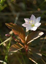
. Its emblem is the Arctic starflower
Trientalis europaea
Trientalis europaea is a plant in the Myrsinaceae family, called by the common name chickweed wintergreen or Arctic starflower. It is a small herbaceous perennial plant with one or more whorls of obovate leaves. The leaves take on a copper hue in late summer. The solitary white flowers appear in...
(the Siebenstern).
Address
Headquarters: Theresienstraße 2, 95632 Wunsiedel in the Haus des Fichtelgebirgsvereins (near the Marktplatz/Rathaus); Expertise and service centre for hiking, paths, conservation, culture and local history; regional specialist library.; FGV Shop; conference and exhibition rooms.Club aims
The aims of the club are the fostering of hiking, training of hiking guides, marking of footpaths, construction and maintenance of rock climbing facilities, observation towerObservation tower
An observation tower is a structure used to view events from a long distance and to create a full 360 degree range of vision. They are usually at least tall and made from stone, iron, and wood. Many modern towers are also used as TV towers, restaurants, or churches...
s and accommodation facilities, conservation work and support, landscape conservation, support of local culture, monument protection, running the Fichtelgebirge Museum
Fichtelgebirge Museum
The Fichtelgebirge Museum is a regional museum in Wunsiedel, formerly the 'capital' of the Sechsämterland and the county town in the Fichtelgebirge mountains of central Germany....
and other local history and natural history collections, publication of the club magazine Der Siebenstern and other heritage publications, youth work and youth support.
History
In 1878 the Fichtelgebirge Section (Sektion Fichtelgebirg) of the German and Austrian Alpine ClubGerman and Austrian Alpine Club
The German and Austrian Alpine Club was a merger of the German, Austrian and Bohemian branches of the Alpine Club that existed from 1873 to 1938.- External links :*...
was founed in Wunsiedel
Wunsiedel
Wunsiedel is the county town of the Upper Franconian district of Wunsiedel in northeast Bavaria, Germany. The town became well known for its annual Luisenburg Festival and the Rudolf Hess Memorial March held by the Neo-Nazis here until 2005.- Geography :...
. From the outset it focussed only on the development of the Fichtelgebirge. In 1888 the section was disbanded and the FGV founded with its headquarters in Wunsiedel. For a long time it was headed by the master forester (Forstmeister) of Wunsiedel. Over the course of time branches were formed in the surrounding villages and around the turn of the 20th century membership numbers had risen to 1000.
The club enjoyed encouraging growth Aufschwung after the First World War, in 1924 it had 38 local branches with 7000 members. After the Second World War, which had brought the club's activities to a standstill, it underwent a rapid regeneration which saw the foundation of numerous youth groups
Youth club
A youth club or youth social club is a place where young people can meet and enjoy activities such as football, soccer, basketball, table tennis, or video games, and other religious, sports activities are frequently sponsored by a community center....
. In 1936 the headquarters of the club moved to Hof; it returned to Wunsiedel in 2003/04.
Local branches
The club has branches in the following places: Arzberg, Asch (CZ)Aš
Aš is a town in the Karlovy Vary Region of the Czech Republic.-History:Previously uninhabited hills and swamps, the town of Asch was founded in the early 11th century by German colonists. Slavic settlements in the area are not known. The dialect spoken in the town was that of the Upper Palatinate,...
, Bad Alexandersbad
Bad Alexandersbad
Bad Alexandersbad is a municipality of Germany in Oberfranken , in the district of Wunsiedel. Population : 1,240. The municipality consists of the villages Dünkelhammer, Kleinwendern, Sichersreuth and Tiefenbach....
, Bad Berneck
Bad Berneck
Bad Berneck is a spa town in the district of Bayreuth, in Bavaria, Germany. It is situated on the White Main river, in the Fichtelgebirge mountains, 13 km northeast of Bayreuth. Its official title is Bad Berneck im Fichtelgebirge. It lies in the northern part of the Bavarian province of Upper...
, Bayreuth, Berlin
Berlin
Berlin is the capital city of Germany and is one of the 16 states of Germany. With a population of 3.45 million people, Berlin is Germany's largest city. It is the second most populous city proper and the seventh most populous urban area in the European Union...
, Bischofsgrün
Bischofsgrün
Bischofsgrün is a municipality in the district of Bayreuth in Bavaria in Germany.Bischofsgrün is situated within the Fichtelgebirge mountain range between the range's two largest mountains; Schneeberg and the Ochsenkopf...
, Brand/Opf., Ebnath
Ebnath
Ebnath is a municipality in the district of Tirschenreuth in Bavaria, Germany....
, Fichtelberg, Franken, Gefrees
Gefrees
Gefrees is a town in the district of Bayreuth, in Bavaria, Germany. It is situated in the Fichtelgebirge, 21 km northeast of Bayreuth. It was the site a of battle during the Napoleonic Wars....
, Goldkronach
Goldkronach
Goldkronach is a town in the district of Bayreuth, in Bavaria, Germany. It is situated near the Fichtelgebirge, 12 km northeast of Bayreuth.-History:On 25 June 1836, at 22:15, residents awoke to a man yelling "Fire! Fire!"...
, Grafenreuth
Thiersheim
Thiersheim is a municipality in the district of Wunsiedel in Bavaria in Germany.Grafenreuth, now a part of Thiersheim, was the seat of the noble family Gravenreuth for centuries....
, Hallerstein, Hof/Saale, Hohenberg an der Eger
Hohenberg an der Eger
Hohenberg an der Eger is a town in the district of Wunsiedel, in Bavaria, Germany. It is situated on the river Eger, on the border with the Czech Republic, 11 km west of Cheb, and 14 km northeast of Marktredwitz. It was home to Hutschenreuther ceramic....
, Kemnath
Kemnath
Kemnath is a town in the district of Tirschenreuth, in Bavaria, Germany. It is situated near the Fichtelgebirge, 24 km southeast of Bayreuth....
, Kirchenlamitz
Kirchenlamitz
Kirchenlamitz is a town in the district of Wunsiedel, in Bavaria, Germany. It is situated in the Fichtelgebirge, 13 km northwest of Wunsiedel and 19 km south of Hof....
, Kulmbach
Kulmbach
Kulmbach is the capital of the district of Kulmbach in Bavaria in Germany. The town is famous for Plassenburg Castle, which houses the largest tin soldier museum in the world, and for its famous sausages, or Bratwürste.-Location:...
, Marktleuthen
Marktleuthen
Marktleuthen is a municipality in the district of Wunsiedel, in Bavaria, Germany. It is situated on the river Eger, 10 km north of Wunsiedel and 11 km southwest of Selb....
, Marktredwitz
Marktredwitz
Marktredwitz is a municipality in the district of Wunsiedel, in Bavaria, Germany. It is situated 22 km west of Cheb, 50 km east of Bayreuth and 50 km south of Hof/Saale.The town celebrated the Horticultural Show 2006 in cooperation with Cheb....
, Mehlmeisel
Mehlmeisel
Mehlmeisel is a municipality in the district of Bayreuth in Bavaria in Germany....
, Münchberg
Münchberg
Münchberg is a small town in Upper Franconia , Germany. It is sometimes referred to as the Textile Town of Bavaria. Its sister city is Jefferson City, Missouri, USA.-The city district's:-History:...
, Nagel
Nagel, Bavaria
Nagel is a municipality in the district of Wunsiedel in Bavaria in Germany....
, Nemmersdorf
Goldkronach
Goldkronach is a town in the district of Bayreuth, in Bavaria, Germany. It is situated near the Fichtelgebirge, 12 km northeast of Bayreuth.-History:On 25 June 1836, at 22:15, residents awoke to a man yelling "Fire! Fire!"...
, Neusorg
Neusorg
Neusorg is a municipality in the district of Tirschenreuth in Bavaria, Germany....
, Niederlamitz, Nuremberg
Nuremberg
Nuremberg[p] is a city in the German state of Bavaria, in the administrative region of Middle Franconia. Situated on the Pegnitz river and the Rhine–Main–Danube Canal, it is located about north of Munich and is Franconia's largest city. The population is 505,664...
, Oberkotzau
Oberkotzau
Oberkotzau is a municipality in Upper Franconia in the district of Hof in Bavaria in Germany....
, Oberwarmensteinach, Pegnitz, Plauen
Plauen
Plauen is a town in the Free State of Saxony, east-central Germany.It is the capital of the Vogtlandkreis. The town is situated near the border of Bavaria and the Czech Republic.Plauen's slogan is Plauen - echt Spitze.-History:...
, Pullenreuth
Pullenreuth
Pullenreuth is a municipality in the district of Tirschenreuth in Bavaria, Germany....
, Rehau
Rehau
Rehau is a town in the district of Hof, in Bavaria, Germany. The first documented name of Rehau was "Resawe" in the year 1234. Rehau is situated in the Fichtelgebirge, 12 km southeast of Hof, and 12 km west of Aš...
, Röslau
Röslau
Röslau is a municipality in the district of Wunsiedel in Bavaria in Germany....
, Schirnding
Schirnding
Schirnding is a municipality in the district of Wunsiedel in Bavaria in Germany....
, Schönwald, Schwarzenbach (Saale)
Schwarzenbach an der Saale
Schwarzenbach an der Saale is a town in the district of Hof, in Bavaria, Germany. It is situated on the river Saale, 11 km south of Hof. Within the town is the Gedenkstätte Langer Gang, a memorial to the Nazi victims of the Helmbrechts concentration camp, which was near Schwarzenbach an der...
, Schwarzenhammer, Selb
Selb
Selb is a town in the district of Wunsiedel, in Upper Franconia, Bavaria, Germany. It is situated in the Fichtelgebirge, on the border with the Czech Republic, 20 km northwest of Cheb and 23 km southeast of Hof.-Notable people:...
-Stadt, Selb-Plößberg, Sparneck
Sparneck
Sparneck is a municipality in Upper Franconia in the district of Hof in Bavaria in Germany.- Location :The market town of Sparneck lies at an average height of in the Pfarrbach valley, which forms the larger part of the area. The Saxon Saale river flows through this valley in a northerly direction...
, Speichersdorf
Speichersdorf
Speichersdorf is a municipality in the district of Bayreuth in Bavaria in Germany. It is situated near the Fichtelgebirge, 18 km eastern of Bayreuth. It has a population of about 6,200.-External links:*...
, Thiersheim
Thiersheim
Thiersheim is a municipality in the district of Wunsiedel in Bavaria in Germany.Grafenreuth, now a part of Thiersheim, was the seat of the noble family Gravenreuth for centuries....
, Thierstein, Tröstau
Tröstau
Tröstau is a municipality in the district of Wunsiedel in Bavaria in Germany....
, Vordorf
Vordorf
Vordorf is a municipality in the district of Gifhorn, in Lower Saxony, Germany. It is a member municipality of the Samtgemeinde Papenteich. The Municipality Vordorf includes the villages of Eickhorst, Rethen and Vordorf.-Municipal Council:...
, Waldershof
Waldershof
Waldershof is a town in the district of Tirschenreuth, in Bavaria, Germany. It is situated 22 km northwest of Tirschenreuth, and 3 km southwest of Marktredwitz....
, Warmensteinach
Warmensteinach
Warmensteinach is a municipality in the district of Bayreuth in Bavaria in Germany.From here there is a chairlift, the Ochsenkopf South Chairlift, to the summit of the Ochsenkopf, the second highest mountain in the Fichtelgebirge....
, Weidenberg
Weidenberg
Weidenberg is a municipality in the district of Bayreuth in Bavaria in Germany. The Ölschnitz river discharges near Weidenberg-Neunkirchen into the Red Main....
, Weißenstadt
Weißenstadt
Weißenstadt is a town in the district of Wunsiedel, in Upper Franconia, Bavaria, Germany. It is situated in the Fichtelgebirge Mountains, on the river Eger, 11 km northwest of Wunsiedel.- Geography :...
, Weißenstein-Verein, Wunsiedel
Wunsiedel
Wunsiedel is the county town of the Upper Franconian district of Wunsiedel in northeast Bavaria, Germany. The town became well known for its annual Luisenburg Festival and the Rudolf Hess Memorial March held by the Neo-Nazis here until 2005.- Geography :...
, Zell im Fichtelgebirge
Zell im Fichtelgebirge
Zell im Fichtelgebirge, formerly Zell is a market town in the district of Hof in Bavaria in Germany.- Geography :...
.
Accommodation
- Kösseinehaus
- Seehaus
- Waldsteinhaus
- Ochsenkopfhaus
- Asenturm-Tagesgaststätte
- Marktredwitzer Haus
- Gänskopfhütte
- Tauritzmühle
- Vordorfer Haus
- Marktleuthener Haus
- Weißensteinhaus
Observation towers
- Schönburgwarte on the Großer KornbergGroßer KornbergWith its high peak the Große Kornberg is the northeast cornerstone of the Fichtelgebirge Mountains in south Germany. It forms a wooded ridge, which is recognisable from a long distance by its former military surveillance tower It is also the local 'house' mountain of Schönwald and Schwarzenbach an...
- Kösseine Tower
- Asenturm on the OchsenkopfOchsenkopf (Fichtelgebirge)The Ochsenkopf is the second-highest mountain in the Fichtelgebirge with a height of . On its summit is an observation tower and a transmission tower for VHF and TV programmes by Bayerischer Rundfunk....
- Waldenfelswarte on the KohlbergKohlberg (Fichtelgebirge)The Kohlberg is a forested mountain made of quartz phyllite in northeast Bavaria, south of Arzberg . Its summit is high and it is one of the highest mountains in the Fichtelgebirge range.- History :...
near Arzberg - Prinz Rupprecht Tower near Bad BerneckBad BerneckBad Berneck is a spa town in the district of Bayreuth, in Bavaria, Germany. It is situated on the White Main river, in the Fichtelgebirge mountains, 13 km northeast of Bayreuth. Its official title is Bad Berneck im Fichtelgebirge. It lies in the northern part of the Bavarian province of Upper...
Rock climbing sites
- Arnsteinfels
- Hirschstein
- Großer Haberstein near the Luisenburg
- Prinzenfelsen
- Nußhardtfelsen
- Rudolfstein
- Weißmainfelsen
- Wetzsteinfelsen
- Lug ins Land
- Schüssel on dem Waldstein
- Hohenstein
- Hügelfelsen
- Katzentrögel (abandoned in 2007)
- Saubadfelsen
- Reiseneggerfelsen
FGV main footpaths
- Franconian Mountain Way (Fränkische Gebirgsweg); length in the Fichtelgebirge 260 km
- West Way (Westweg, white "W" on red background), length ca. 76 km
- Münchberg – Weißenstein (near Stammbach) – Gefrees – Stein – Bad Berneck – Fürstenstein – Sophienthal – Gänskopfhütte – Haidenaabquelle – Ahornberg – Immenreuth – Kemnath – Rauher Kulm
- High Way (Höhenweg, white "H" on red background) ca. 46 km
- Schwarzenbach/Saale – Großer WaldsteinGroßer WaldsteinThe Großer Waldstein is part of the Waldstein range in the Fichtelgebirge Mountains of Germany. It is known primarily for its rock formations caused by so-called 'woolsack' weathering , its ruined castles and the only remaining bear trap in the region.The River Saale rises at the foot of the...
– WeißenstadtWeißenstadtWeißenstadt is a town in the district of Wunsiedel, in Upper Franconia, Bavaria, Germany. It is situated in the Fichtelgebirge Mountains, on the river Eger, 11 km northwest of Wunsiedel.- Geography :...
– Rudolfstein – Schneeberg – Nußhardt – Seehaus – Platte – Silberhaus – Hohe MätzeHohe MatzeThe Hohe Matze, also known as the Hohe Mätze, is a mountain in the southern part of the Fichtelgebirge Mountains of central Germany. It lies between Nagel and Tröstau, and its high summit is a jumble of oval-shaped rocks...
– Kösseine – Haberstein – Luisenburg – Wunsiedel
- Schwarzenbach/Saale – Großer Waldstein
- North Way (Nordweg, white "N" on red background) ca. 66 km
- Kulmbach – Fölschnitz- Wirsberg – Gefrees – Großer WaldsteinGroßer WaldsteinThe Großer Waldstein is part of the Waldstein range in the Fichtelgebirge Mountains of Germany. It is known primarily for its rock formations caused by so-called 'woolsack' weathering , its ruined castles and the only remaining bear trap in the region.The River Saale rises at the foot of the...
– EpprechtsteinEpprechtsteinThe Epprechtstein is a mountain in the northern Fichtelgebirge in northeast Bavaria, . It is mineralogically the most interesting mountain in the entire Fichtelgebirge range. Around the summit there are about 20 quarries, in three of which Epprechtstein granite is quarried. The others are closed...
– KirchenlamitzKirchenlamitzKirchenlamitz is a town in the district of Wunsiedel, in Bavaria, Germany. It is situated in the Fichtelgebirge, 13 km northwest of Wunsiedel and 19 km south of Hof....
– Hirschstein – Kornberg – Vorsuchhütte- Selb – Hirschfelder Tor
- Kulmbach – Fölschnitz- Wirsberg – Gefrees – Großer Waldstein
- Middle Way (Mittelweg, black "M" on yellow background) ca. 68 km
- Bayreuth – Untersteinach – Königsheide – Ochsenkopf – Weißmainquelle – Weißmainfelsen – Seehaus – Vordorfermühle – Vordorf – Zeitelmoos – Thierstein – Hohenberg/Eger
- South Way (Südweg, black "S" on yellow background) ca. 68 km
- Wirsberg – Neuenmarkt – Bad Berneck – Goldmühl – Warmensteinach – Bayreuther Haus – Immenreuth – Armesberg – Friedenfels – Wiesau
- East Way (Ostweg, white "O" on red background) ca. 57 km
- Tripoint (Dreiländereck) – branch to Rehau – Rehau – Wildenau – Wartberg – Großer Hengstberg – Hohenberg/Eger – Schirnding – Kappel – Waldsassen
- Steinwald Way (Steinwaldweg, white and red bars) ca. 38 km
- Kösseinegipfel – Langentheilen – Katzentrögel/Platte – Weißenstein – Teichelberg – Waldsassen
- Springs Way (Quellenweg, black "Q" on yellow background) ca. 46 km
- Münchberg – Zell – source of the Saxon Saale – Eger source – Weißenhaider EckWeißenstadtWeißenstadt is a town in the district of Wunsiedel, in Upper Franconia, Bavaria, Germany. It is situated in the Fichtelgebirge Mountains, on the river Eger, 11 km northwest of Wunsiedel.- Geography :...
-Karches – White Main source – Weißmainfelsen – Fichtelnaab source – Fichtelsee – Nagel – Luisenburg – Alexandersbad – Marktredwitz
- Münchberg – Zell – source of the Saxon Saale – Eger source – Weißenhaider Eck
- Eger Way (Egerweg, black "E" on yellow background) ca. 43 km
- Egerquelle – WeißenstadtWeißenstadtWeißenstadt is a town in the district of Wunsiedel, in Upper Franconia, Bavaria, Germany. It is situated in the Fichtelgebirge Mountains, on the river Eger, 11 km northwest of Wunsiedel.- Geography :...
– Röslau – Marktleuthen – Schwarzenhammer – Wellerthal – Hohenberg/ Eger – Fischern
- Egerquelle – Weißenstadt
- Röslau Way (Röslauweg, black "R" on yellow background) ca. 40 km
- Röslau source – Vordorfermühle – Leupoldsdorf – Tröstau – Wunsiedel – Lorenzreuth – Seußen – Arzberg – Schirnding – Fischen