

Fenny Drayton
Encyclopedia
Fenny Drayton is a village in Leicestershire
England, in the district of Hinckley and Bosworth
. Near to the county border of Warwickshire and using a Warwickshire County postcode, it is just off the A444 road
an old Roman road, north of Nuneaton
close to its crossroads with the A5 (the Roman road
called Watling Street
). The hamlet is also crossed by another Roman Road, and is found at the end of the scenic country lane of the Fenn Lanes. It is four miles from the village of Stoke Golding
(where King Henry VII was crowned immediately after the Battle of Bosworth Field in 1485).
The hamlet church of St Michael and All Angels', Church of England, in the Diocese of Leicester
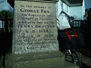
is of a Gothic design, having 12th century Norman features with a 13th century fully operational bell tower and is surrounded by one of the oldest circles of giant [yew] trees in the United Kingdom. George Fox, the founder of the worldwide Quaker (Religious Society of Friends) movement, was born in Fenny Drayton and is reputed to have been baptized in the older of the two fonts in the church. There is a large monument to him in the hamlet where two roads, George Fox Lane and Old Forge Road meet. Quakers from all over the world visit the hamlet and church, and sign the church visitors' book. There are two important monuments of the Purefoy Family dating back to 1543 in the church grounds. One has an incised slab which is very rare. The church is open to the public free of charge by appointment.
The Ordnance Survey
have defined the nearby Lindley Hall Farm as the centre point of England.
The Casa Blanca public house, which was renamed The Royal Haven, is now the site of a housing estate.
. In 2003 the Ordnance Survey placed Coton in the Elms
, Derbyshire, 24 kilometres (14.9 mi) north, as the 'furthest point from the sea' in Great Britain.
Leicestershire
Leicestershire is a landlocked county in the English Midlands. It takes its name from the heavily populated City of Leicester, traditionally its administrative centre, although the City of Leicester unitary authority is today administered separately from the rest of Leicestershire...
England, in the district of Hinckley and Bosworth
Hinckley and Bosworth
Hinckley and Bosworth is a local government district with borough status in south-western Leicestershire, England, administered by Hinckley and Bosworth Borough Council. Its only towns are Hinckley, Earl Shilton and Market Bosworth...
. Near to the county border of Warwickshire and using a Warwickshire County postcode, it is just off the A444 road
A444 road
The A444 is a primary road running between Coventry and Burton on Trent in England, usually referred to as the "A treble four".-Route:Starting on the A4600 Sky Blue Way in Coventry, the road heads north on a dual carriageway road, crossing the M6 at junction 3. It bypasses Bedworth to the west and...
an old Roman road, north of Nuneaton
Nuneaton
Nuneaton is the largest town in the Borough of Nuneaton and Bedworth and in the English county of Warwickshire.Nuneaton is most famous for its associations with the 19th century author George Eliot, who was born on a farm on the Arbury Estate just outside Nuneaton in 1819 and lived in the town for...
close to its crossroads with the A5 (the Roman road
Roman Britain
Roman Britain was the part of the island of Great Britain controlled by the Roman Empire from AD 43 until ca. AD 410.The Romans referred to the imperial province as Britannia, which eventually comprised all of the island of Great Britain south of the fluid frontier with Caledonia...
called Watling Street
Watling Street
Watling Street is the name given to an ancient trackway in England and Wales that was first used by the Britons mainly between the modern cities of Canterbury and St Albans. The Romans later paved the route, part of which is identified on the Antonine Itinerary as Iter III: "Item a Londinio ad...
). The hamlet is also crossed by another Roman Road, and is found at the end of the scenic country lane of the Fenn Lanes. It is four miles from the village of Stoke Golding
Stoke Golding
Stoke Golding is a village and civil parish in the Hinckley and Bosworth district of Leicestershire, England, which lies in the heart of England, in South West Leicestershire, close to the Warwickshire county border. According to the 2001 census the total population was 1,721, living in just over...
(where King Henry VII was crowned immediately after the Battle of Bosworth Field in 1485).
Geography
Primary school children mostly attend either the well respected St Margaret's Church of England Primary School in Stoke Golding, or the internationally awarded Dixie Grammar School in nearby Market Bosworth village.The hamlet church of St Michael and All Angels', Church of England, in the Diocese of Leicester
Diocese of Leicester
The Diocese of Leicester is a Church of England diocese based in Leicester and including the current county of Leicestershire. The cathedral is Leicester Cathedral, where the Bishop of Leicester has his seat....
is of a Gothic design, having 12th century Norman features with a 13th century fully operational bell tower and is surrounded by one of the oldest circles of giant [yew] trees in the United Kingdom. George Fox, the founder of the worldwide Quaker (Religious Society of Friends) movement, was born in Fenny Drayton and is reputed to have been baptized in the older of the two fonts in the church. There is a large monument to him in the hamlet where two roads, George Fox Lane and Old Forge Road meet. Quakers from all over the world visit the hamlet and church, and sign the church visitors' book. There are two important monuments of the Purefoy Family dating back to 1543 in the church grounds. One has an incised slab which is very rare. The church is open to the public free of charge by appointment.
The Ordnance Survey
Ordnance Survey
Ordnance Survey , an executive agency and non-ministerial government department of the Government of the United Kingdom, is the national mapping agency for Great Britain, producing maps of Great Britain , and one of the world's largest producers of maps.The name reflects its creation together with...
have defined the nearby Lindley Hall Farm as the centre point of England.
The Casa Blanca public house, which was renamed The Royal Haven, is now the site of a housing estate.
Centre of England
In 2002 the Ordnance Survey defined 'Lindley Hall farm' as the Geographical Centre of EnglandCentre points of the United Kingdom
There has long been debate over the exact location of the geographical centre of the United Kingdom, and its constituent countries, due to the complexity and method of the calculation, such as whether to include offshore islands, and the fact that erosion will cause the position to change over time...
. In 2003 the Ordnance Survey placed Coton in the Elms
Coton in the Elms
Coton in the Elms is a village and parish in the English county of Derbyshire. It is located five miles south of Burton upon Trent.South east of the village is Church Flatts Farm, which is defined by the Ordnance Survey as the farthest point from the sea in Great Britain.-History:Coton is mentioned...
, Derbyshire, 24 kilometres (14.9 mi) north, as the 'furthest point from the sea' in Great Britain.
Notable residents
- George FoxGeorge FoxGeorge Fox was an English Dissenter and a founder of the Religious Society of Friends, commonly known as the Quakers or Friends.The son of a Leicestershire weaver, Fox lived in a time of great social upheaval and war...
, founder of the Religious Society of FriendsReligious Society of FriendsThe Religious Society of Friends, or Friends Church, is a Christian movement which stresses the doctrine of the priesthood of all believers. Members are known as Friends, or popularly as Quakers. It is made of independent organisations, which have split from one another due to doctrinal differences...
spent his childhood in Fenny Drayton.
See also
- Coastline of the United Kingdom
- Coton in the ElmsCoton in the ElmsCoton in the Elms is a village and parish in the English county of Derbyshire. It is located five miles south of Burton upon Trent.South east of the village is Church Flatts Farm, which is defined by the Ordnance Survey as the farthest point from the sea in Great Britain.-History:Coton is mentioned...
, Derbyshire, 24 kilometres (14.9 mi) north, 'furthest point from the sea' in Great Britain.