

Fairhaven, Svalbard
Encyclopedia
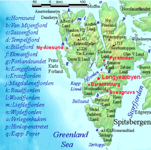
Amsterdamøya
Amsterdamøya is a small island off the northwest coast of West-Spitsbergen.-History:Amsterdamøya was first seen by Willem Barents in 1596. The Dutch first occupied it in 1614 , building a temporary whaling station on the island's southeastern promontory. In 1619 a semi-permanent station was...
and Danskøya
Danskøya
Danskøya is an island in Norway's Svalbard archipelago in the Arctic Ocean. It lies just off the northwest coast of Spitsbergen, the largest island in the archipelago, near to Magdalenefjorden. Just to the north lies Amsterdamøya. Like many of Svalbard's islands, Danskøya is uninhabited...
and the mainland, while specifically it refers to the sound
Sound (geography)
In geography a sound or seaway is a large sea or ocean inlet larger than a bay, deeper than a bight and wider than a fjord; or it may be defined as a narrow sea or ocean channel between two bodies of land ....
between Danskøya and the mainland (Albert I Land), in particular the strait between Moseøya and Danskøya. The modern name for this area is Smeerenburgfjorden (a modern blunder, as Smeerenburg
Smeerenburg
The settlement of Smeerenburg on Amsterdam Island in north-west Svalbard, originated with Danish and Dutch whalers in 1619: one of Europe's northernmost outposts.-Reality:...
was only a settlement).
The fjord
Fjord
Geologically, a fjord is a long, narrow inlet with steep sides or cliffs, created in a valley carved by glacial activity.-Formation:A fjord is formed when a glacier cuts a U-shaped valley by abrasion of the surrounding bedrock. Glacial melting is accompanied by rebound of Earth's crust as the ice...
is 20 km long and 4 km wide.
History
Willem Barentsz was the first to explore the area around Fairhaven in 1596. The first indisputable visit by the English was made by Jonas PooleJonas Poole
Jonas Poole was an early 17th century English explorer, sealer, and whaler. Although Henry Hudson has often been dubbed the "father of English whaling," Poole, who's 1610 voyage led to the establishment of the English whaling trade, deserves the title.-Voyages to Bear Island, 1604-1609:He served...
in the Amity in 1610. Thomas Marmaduke
Thomas Marmaduke
Thomas Marmaduke was an English explorer, sealer, and whaler in the early 17th century.-Career:In a list dated from September 1600 Marmaduke is mentioned as being a younger brother of the Hull Trinity House. He was master of one of the two Hull interlopers sent to Bjørnøya in 1609...
is known to have explored the area north of Fairhaven in 1612, and may have explored Fairhaven itself as well. Again, the following season (1613), Marmaduke explored as far north as Fairhaven. The first known whaling here occurred in 1614, with the Dutch
Netherlands
The Netherlands is a constituent country of the Kingdom of the Netherlands, located mainly in North-West Europe and with several islands in the Caribbean. Mainland Netherlands borders the North Sea to the north and west, Belgium to the south, and Germany to the east, and shares maritime borders...
resorting to Amsterdamøya and the English to the south. Here they both establish temporary whaling stations, the former most likely on the southeastern spit of Amsterdamøya, and the latter probably on the southeastern corner of Danskøya. In 1615, they again made their way to their respective anchorages in Fairhaven. In 1619 and 1620 there were also at least two Danish
Denmark
Denmark is a Scandinavian country in Northern Europe. The countries of Denmark and Greenland, as well as the Faroe Islands, constitute the Kingdom of Denmark . It is the southernmost of the Nordic countries, southwest of Sweden and south of Norway, and bordered to the south by Germany. Denmark...
ships sharing the southern area with the English. The English continued to send ships to Fairhaven until 1624 or 1625, when the Dutch took over the area.
In 1619 the Dutch replaced the tents and temporary tryworks on Amsterdamøya with permanent structures of wood and brick, in what would become known as Smeerenburg, or "Blubbertown." At first only the men of Amsterdam and the Danes established themselves on the island, with the former claiming the east and the latter the west. By 1623 several chambers of the Noordsche Compagnie
Noordsche Compagnie
The Noordsche or Groenlandse Compagnie was a cartel for whaling, founded by several cities in the Netherlands...
had erected structures for the processing and warehousing of whale oil, and by 1633 all the chambers were represented. Up to 200 men worked ashore during the peak years in the mid-1630s. The settlement began to decline in the early 1640s, and was probably abandoned in the following decade.
In 1636, another station, called the "Cookery of Harlingen", was established by the Dutch in Houcker Bay (Virgohamna) on the north side of Danskøya. The remains of this station were seen by Frederich Martens in 1671. In 1888/1889 Arnold Pike wintered in a hut he built on almost the exact site of the former station. In 1896 Herr Andrée established himself here in an attempt to reach the North Pole by balloon, but was forced to return to Sweden. He returned to Houcker Bay the following summer (1897), and accompanied by two others, left Houcker Bay on July 11 in the balloon Eagle. They were never heard of again. Parties from Andrée’s ship, the Virgo, surveyed Fairhaven and the surrounding area.
Cartography
Fairhaven was named by Poole in 1610. The name is marked on the maps of DanielDaniel
Daniel is the protagonist in the Book of Daniel of the Hebrew Bible. In the narrative, when Daniel was a young man, he was taken into Babylonian captivity where he was educated in Chaldean thought. However, he never converted to Neo-Babylonian ways...
(1612), Carolus
Joris Carolus
Joris Carolus was a Dutch cartographer and explorer. He served for both the Noordsche Compagnie and the Vereenigde Oost-Indische Compagnie .-Career:...
(1614), Goos
Goos
Goos is a commune in the Landes department in Aquitaine in south-western France. Its main source of income is tourism due to the local scenery....
(1620), Guerard (1628), Vrolicq
Jean Vrolicq
Jean Vrolicq was a mariner from St-Jean-de-Luz in the first half of the 17th century...
(1634), Carolus (1634), Colom (1648), and others. The Dutch called it Dutch Bay or Mauritius Bay, while Carolus (1614) marked it Hollandsche Bay. Although Mauritius Bay appears not to have been marked until Doncker’s local map (1655), it was written of frequently and early on in Dutch official documents. As previously mentioned, Smeerenburgfjorden is a modern blunder.
Fairhaven was further divided north and south. The Englishman Robert Fotherby
Robert Fotherby
Robert Fotherby was an early 17th century English explorer and whaler. From 1613 to 1615 he worked for the Muscovy Company, and from 1615 until his death for the East India Company.-Family Ties:...
(1614) simply split the area into a "north harbor," where the Dutch established themselves, and a "south harbor," where the English were. The Dutch referred to the area northeast of Smeerenburg between the mainland and the island as North gat or North Bay, while they called the area where the English were English Bay or English harbor. The southwestern entrance to Fairhaven, between Danskøya and the mainland south of it, was first designated South gat by Doncker (1655), which is where the modern name, Sørgattet, comes from.
Amsterdamøya was first landed on by Barents in 1596. He named the island and the group of islands around it Gebroocken Land. It was probably first named Amsterdam Island in or after 1614, when the Dutch whalers first resorted to the island. The sound south of Amsterdamøya, between it and Danskøya, was variously named South bay, West bay, or Middel gat by the Dutch. It incorrectly became known as Danes gat by modern writers, and is now designated as Danskegattet. Martin Conway believes that the correct historical name is Middel gat.
Danskøya (Danes island) is first marked on Doncker’s map (1655). It is named after the Danish whalers who resorted there. On the island’s west coast, in Robbe Bay (Kobbefjorden), they established a permanent station in 1631, which they occupied until 1658. Robbe Bay is first marked on Dutch maps from Middelhoven’s (1634) to that of Giles and Rep (c. 1710). The latter mapmakers were the first to call it Danes Bay, while the Danish themselves called it Copenhagen Bay. The English called the islands southwest point Gurnerd’s Nose, while the Dutch called it Engelsche Uytkyk, or English Outlook. The bay in the north coast was called by the Dutch Houcker Bay, but has been renamed Virgo Bay (Virgohamna) after Andrée’s steamer. Off the northeastern coast lays a small island, which the Dutch called Deadman’s Island, which, as the name suggests, was used as a graveyard by the whalers. It is now known by its Norwegian equivalent, Likholmen (Corpse Island).
Modern Fairhaven
South of Fuglesongen, Klovningen, and Ytre NorskøyaYtre Norskøya
Ytre Norskøya is an island on the northwest coast of Spitsbergen, part of the Svalbard archipelago.-History:Remains of a whaling station exist on the southern side of the island, possibly rivaling Smeerenburg in size. It was Europe's northernmost outpost ever established until the early 19th...
modern charts wrongly mark Fairhaven. As mentioned in the introduction, the true Fairhaven is the area to the south between Amsterdamøya and Danskøya and the mainland.