
Executive Committee Range
Encyclopedia
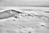
The Executive Committee Range is a range
consisting of five major mountain
s, volcanic in origin, which trends north-south for 80 km (49.7 mi) along the 126th meridian west
, in Marie Byrd Land
, Antarctica.
Discovered by the United States Antarctic Service expedition on a flight, December 15, 1940, and named for the Antarctic Service Executive Committee. Individual mountains (e.g. Hampton
, Waesche
) are named in honor of members of the committee, except for Mount Sidley
, the most imposing mountain in the range, which was discovered and named by Rear Admiral Byrd in 1934. The entire range was mapped in detail by USGS from surveys and U.S. Navy trimetrogon photography, 1958-60.
Mountains of this range include Mount Sidley
, Mount Waesche
and Mount Hampton
.
and Mount Hartigan. A circular snow-covered crater occupies the summit area. Discovered by the U.S. Antarctic Service (USAS) (1939–41) on a flight, Dec. 15, 1940, and named for Hugh S. Cumming, Jr., State Department member of the U.S. Antarctic Service (USAS) Executive Committee. Mapped by U.S. Geological Survey (USGS) from surveys and U.S. Navy trimetrogon photography, 1958-60.
. Discovered by the United States Antarctic Service expedition on a flight, Dec. 15, 1940, and named for Rear Admiral Charles C. Hartigan, U.S. Navy (USN), Navy Department member of the Antarctic Service Executive Committee.
on the east side of the crater rim of Mount Cumming. Mapped by United States Geological Survey
(USGS) from surveys and U.S. Navy aerial photographs, 1958-60. Named by Advisory Committee on Antarctic Names
(US-ACAN) for Howard A. Le Vaux, auroral physicist at Byrd Station
, 1959, and a member of the Marie Byrd Land Traverse Party, 1959-60.
Mountain range
A mountain range is a single, large mass consisting of a succession of mountains or narrowly spaced mountain ridges, with or without peaks, closely related in position, direction, formation, and age; a component part of a mountain system or of a mountain chain...
consisting of five major mountain
Mountain
Image:Himalaya_annotated.jpg|thumb|right|The Himalayan mountain range with Mount Everestrect 58 14 160 49 Chomo Lonzorect 200 28 335 52 Makalurect 378 24 566 45 Mount Everestrect 188 581 920 656 Tibetan Plateaurect 250 406 340 427 Rong River...
s, volcanic in origin, which trends north-south for 80 km (49.7 mi) along the 126th meridian west
126th meridian west
The meridian 126° west of Greenwich is a line of longitude that extends from the North Pole across the Arctic Ocean, North America, the Pacific Ocean, the Southern Ocean, and Antarctica to the South Pole....
, in Marie Byrd Land
Marie Byrd Land
Marie Byrd Land is the portion of West Antarctica lying east of the Ross Ice Shelf and the Ross Sea and south of the Pacific Ocean, extending eastward approximately to a line between the head of the Ross Ice Shelf and Eights Coast. It stretches between 158°W and 103°24'W...
, Antarctica.
Discovered by the United States Antarctic Service expedition on a flight, December 15, 1940, and named for the Antarctic Service Executive Committee. Individual mountains (e.g. Hampton
Mount Hampton
Mount Hampton is a shield volcano with a circular ice-filled crater occupying much of the summit area. It is the northernmost of the extinct volcanoes which comprise the Executive Committee Range in Marie Byrd Land....
, Waesche
Mount Waesche
Mount Waesche is a large and prominent mountain of volcanic origin, standing immediately SW of Mount Sidley and marking the southern end of the Executive Committee Range in Marie Byrd Land. The feature is snow covered except for rock exposures on the south and southwestern slopes...
) are named in honor of members of the committee, except for Mount Sidley
Mount Sidley
Mount Sidley is the highest volcano in Antarctica, a member of the Volcanic Seven Summits, with a summit elevation of . It is a massive, mainly snow-covered shield volcano which is the highest and most imposing of the five extinct volcanic mountains that comprise the Executive Committee Range of...
, the most imposing mountain in the range, which was discovered and named by Rear Admiral Byrd in 1934. The entire range was mapped in detail by USGS from surveys and U.S. Navy trimetrogon photography, 1958-60.
Mountains of this range include Mount Sidley
Mount Sidley
Mount Sidley is the highest volcano in Antarctica, a member of the Volcanic Seven Summits, with a summit elevation of . It is a massive, mainly snow-covered shield volcano which is the highest and most imposing of the five extinct volcanic mountains that comprise the Executive Committee Range of...
, Mount Waesche
Mount Waesche
Mount Waesche is a large and prominent mountain of volcanic origin, standing immediately SW of Mount Sidley and marking the southern end of the Executive Committee Range in Marie Byrd Land. The feature is snow covered except for rock exposures on the south and southwestern slopes...
and Mount Hampton
Mount Hampton
Mount Hampton is a shield volcano with a circular ice-filled crater occupying much of the summit area. It is the northernmost of the extinct volcanoes which comprise the Executive Committee Range in Marie Byrd Land....
.
Mount Cumming
Mount Cumming (76°40′S 125°48′W) is a low, mostly snow-covered mountain, volcanic in origin, located midway between Mount HamptonMount Hampton
Mount Hampton is a shield volcano with a circular ice-filled crater occupying much of the summit area. It is the northernmost of the extinct volcanoes which comprise the Executive Committee Range in Marie Byrd Land....
and Mount Hartigan. A circular snow-covered crater occupies the summit area. Discovered by the U.S. Antarctic Service (USAS) (1939–41) on a flight, Dec. 15, 1940, and named for Hugh S. Cumming, Jr., State Department member of the U.S. Antarctic Service (USAS) Executive Committee. Mapped by U.S. Geological Survey (USGS) from surveys and U.S. Navy trimetrogon photography, 1958-60.
Mount Hartigan
Mount Hartigan (76°52′S 126°00′W) is a broad, mostly snow-covered mountain with several individually named peaks which rise up to 2800 metres (9,186 ft), situated immediately north of Mount SidleyMount Sidley
Mount Sidley is the highest volcano in Antarctica, a member of the Volcanic Seven Summits, with a summit elevation of . It is a massive, mainly snow-covered shield volcano which is the highest and most imposing of the five extinct volcanic mountains that comprise the Executive Committee Range of...
. Discovered by the United States Antarctic Service expedition on a flight, Dec. 15, 1940, and named for Rear Admiral Charles C. Hartigan, U.S. Navy (USN), Navy Department member of the Antarctic Service Executive Committee.
Le Vaux Peak
Le Vaux Peak (76°40′S 125°43′W) is a small peakSummit (topography)
In topography, a summit is a point on a surface that is higher in elevation than all points immediately adjacent to it. Mathematically, a summit is a local maximum in elevation...
on the east side of the crater rim of Mount Cumming. Mapped by United States Geological Survey
United States Geological Survey
The United States Geological Survey is a scientific agency of the United States government. The scientists of the USGS study the landscape of the United States, its natural resources, and the natural hazards that threaten it. The organization has four major science disciplines, concerning biology,...
(USGS) from surveys and U.S. Navy aerial photographs, 1958-60. Named by Advisory Committee on Antarctic Names
Advisory Committee on Antarctic Names
The Advisory Committee on Antarctic Names is an advisory committee of the United States Board on Geographic Names responsible for recommending names for features in Antarctica...
(US-ACAN) for Howard A. Le Vaux, auroral physicist at Byrd Station
Byrd Station
Byrd Station refers to a research station established by the United States during the International Geophysical Year by the U.S. Navy during Operation Deep Freeze II in West Antarctica at 80°, 120°W...
, 1959, and a member of the Marie Byrd Land Traverse Party, 1959-60.