

Eritrean Highlands
Encyclopedia
Ethiopian Highlands
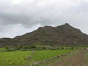
The Ethiopian Highlands are a rugged mass of mountains in Ethiopia, Eritrea , and northern Somalia in the Horn of Africa...
to the south. The region has seen tremendous deforestation
Deforestation
Deforestation is the removal of a forest or stand of trees where the land is thereafter converted to a nonforest use. Examples of deforestation include conversion of forestland to farms, ranches, or urban use....
since the Italian Colonial period which began in the late 19th century. The Highlands are at particular risk of deforestation and associated soil erosion. Furthermore the region, lying south of the Sahel
Sahel
The Sahel is the ecoclimatic and biogeographic zone of transition between the Sahara desert in the North and the Sudanian Savannas in the south.It stretches across the North African continent between the Atlantic Ocean and the Red Sea....
are at particular risk of desertification and frequent drought. The Highlands experience, as most tropical regions, two seasons; the rainy season (kremti) is from June-September while the dry season is from September to June. The average temperature for the Highlands is approximately 16°C. The tallest pointed in Eritrea
Eritrea
Eritrea , officially the State of Eritrea, is a country in the Horn of Africa. Eritrea derives it's name from the Greek word Erethria, meaning 'red land'. The capital is Asmara. It is bordered by Sudan in the west, Ethiopia in the south, and Djibouti in the southeast...
is located in the Eritrean Highlands at Amba Soira
Amba Soira
Emba Soira is the highest mountain in Eritrea. Rising above sea level, it is part of the Eritrean Highlands, one side of the Great Rift Valley which cuts through Eritrea and joins the Red Sea...
.
The Eritrean Highlands are drained by four major rivers towards Sudan
Sudan
Sudan , officially the Republic of the Sudan , is a country in North Africa, sometimes considered part of the Middle East politically. It is bordered by Egypt to the north, the Red Sea to the northeast, Eritrea and Ethiopia to the east, South Sudan to the south, the Central African Republic to the...
and by several smaller rivers into the Red Sea
Red Sea
The Red Sea is a seawater inlet of the Indian Ocean, lying between Africa and Asia. The connection to the ocean is in the south through the Bab el Mandeb strait and the Gulf of Aden. In the north, there is the Sinai Peninsula, the Gulf of Aqaba, and the Gulf of Suez...
coast of Eritrea
Eritrea
Eritrea , officially the State of Eritrea, is a country in the Horn of Africa. Eritrea derives it's name from the Greek word Erethria, meaning 'red land'. The capital is Asmara. It is bordered by Sudan in the west, Ethiopia in the south, and Djibouti in the southeast...
. Flowing towards Sudan and the Nile River are the Gash and Setit Rivers while towards Sudan without reaching the Nile are the Barka
Barka River
Barka River flows from the Eritrean Highlands to the plains of Sudan. With a length of over 640 km, the Barka rises just outside Asmara, and flows in a northwestern direction through Agordat. It merges with the Anseba River near the border with Sudan....
and Anseba
Anseba River
The Anseba River is a tributary of the Barka River in Eritrea with a length of 346 kilometers. It rises in the Eritrean Highlands outside Asmara and flows in a northwestern direction through Keren. It merges with the Barka River near the border with Sudan....
Rivers. The Eastern Escarpment of Eritrea is drained by numerous small streams.
Many believe that forest cover in the Eritrean Highlands was as high 30% but has since declined to 1%, however, others including Louise Latt have suggested that there has never been such a dramatic decline in forest cover.
Red Sea
The Red Sea is a seawater inlet of the Indian Ocean, lying between Africa and Asia. The connection to the ocean is in the south through the Bab el Mandeb strait and the Gulf of Aden. In the north, there is the Sinai Peninsula, the Gulf of Aqaba, and the Gulf of Suez...
which causes two climactic systems to overlap. This region is oft noted for its perennial forest cover. This is also the region that Eritrea's Merara coffee is grown.
The soil conditions in the Eritrean Highlands is also quite complex. The predominant soils are chromic, eutric, and calsic cambisols of strong red colour. Other soils found in the highlands are lithosols, xerosols and fluvisols.