

Elgar's Special Survey
Encyclopedia
Melbourne
Melbourne is the capital and most populous city in the state of Victoria, and the second most populous city in Australia. The Melbourne City Centre is the hub of the greater metropolitan area and the Census statistical division—of which "Melbourne" is the common name. As of June 2009, the greater...
, Victoria
Victoria (Australia)
Victoria is the second most populous state in Australia. Geographically the smallest mainland state, Victoria is bordered by New South Wales, South Australia, and Tasmania on Boundary Islet to the north, west and south respectively....
, Australia
Australia
Australia , officially the Commonwealth of Australia, is a country in the Southern Hemisphere comprising the mainland of the Australian continent, the island of Tasmania, and numerous smaller islands in the Indian and Pacific Oceans. It is the world's sixth-largest country by total area...
. The land was purchased from the Crown for one pound an acre under the terms of the short-lived Special Survey
Port Phillip District Special Surveys
In August 1840, the Colonial Land and Emigration Commissioners of the British Government decided to allow the purchase of land anywhere in the Port Phillip District of New South Wales – now Victoria, Australia. Special Surveys could be requested to enable the purchase of , or eight square...
regulations.
Elgar's Special Survey covered the area now bounded by Burke Road
Burke Road, Melbourne
Burke Road is a major north-south thoroughfare in Melbourne, Australia. It runs from Ivanhoe to Caulfield, and includes the major shopping district at Camberwell...
(west), Canterbury Road (south), Elgar Road (east) and the Yarra River
Yarra River
The Yarra River, originally Birrarung, is a river in east-central Victoria, Australia. The lower stretches of the river is where the city of Melbourne was established in 1835 and today Greater Melbourne dominates and influences the landscape of its lower reaches...
and Koonung Creek
Koonung Creek
Koonung Creek is a small tributary of the Yarra River in Melbourne's east. The creek originates in Nunawading near Springvale Road, and flows to join the Yarra at the border between Ivanhoe East, Bulleen and Balwyn North. The place the two waterways meet forms the borders between these suburbs...
(north).
It includes all of the Melbourne suburbs of Balwyn
Balwyn, Victoria
Balwyn is a suburb in Melbourne, Victoria, Australia, 10 km east from Melbourne's central business district. Its Local Government Area is the City of Boroondara...
, Balwyn North
Balwyn North, Victoria
Balwyn North is a suburb in Melbourne, Victoria, Australia, 11 km east from Melbourne's central business district. Its Local Government Area is the City of Boroondara...
, Mont Albert
Mont Albert, Victoria
Mont Albert is a suburb in Melbourne, Victoria, Australia, 12 km east from Melbourne's central business district. Its Local Government Area are the Cities of Whitehorse and Boroondara. At the 2006 Census, Mont Albert had a population of 4419....
and Mont Albert North
Mont Albert North, Victoria
Mont Albert North is a suburb in Melbourne, Victoria, Australia, 13 km east from Melbourne's central business district. Its Local Government Area is the City of Whitehorse. At the 2006 Census, Mont Albert North had a population of 5008....
, and the parts of Canterbury
Canterbury, Victoria
Canterbury is a suburb in Melbourne, Victoria, Australia, 10 km east from Melbourne's central business district. Its Local Government Area is the City of Boroondara...
and Surrey Hills
Surrey Hills, Victoria
Surrey Hills is a suburb in Melbourne, Victoria, Australia, 12 km east from Melbourne's central business district. Its Local Government Area lies within the cities of Boroondara and Whitehorse...
north of Canterbury Road.
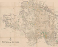
The land is in the parishes of Boroondara and Nunawading in the County of Burke.
The Elgar's Special Survey had a lasting effect on the alignment of Boroondara subdivisions and roads as some boundaries did not conform to the one mile (1.6 km) interval cadastral survey Section lines running north-south and east-west, referenced from the survey datum at Batman's Hill
Batman's Hill
Batman's Hill in Melbourne, Australia was named for the Vandemonian adventurer and grazier John Batman. Now removed, the 18 metre high hill was located to the south of today's Collins Street and Southern Cross railway station, and is the site of a steel marker the same height as the original...
.