
Elerithattu
Encyclopedia
Village
A village is a clustered human settlement or community, larger than a hamlet with the population ranging from a few hundred to a few thousand , Though often located in rural areas, the term urban village is also applied to certain urban neighbourhoods, such as the West Village in Manhattan, New...
, about 30 km east of Nileshwar in the Kasaragod district
Kasaragod district
Kasaragod District is one of the districts of the Indian state of Kerala. Kasaragod District was organised as a separate district on 24 May 1984...
of Kerala
Kerala
or Keralam is an Indian state located on the Malabar coast of south-west India. It was created on 1 November 1956 by the States Reorganisation Act by combining various Malayalam speaking regions....
in India
India
India , officially the Republic of India , is a country in South Asia. It is the seventh-largest country by geographical area, the second-most populous country with over 1.2 billion people, and the most populous democracy in the world...
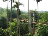
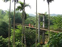
. The settlement is situated in a sylvan
Sylvan
Sylvan, Silvan or Sylvian refers to an association with the woods. Specifically, that which inhabits the wood, is made of tree materials, or comprises the forest itself. The term can also refer to a person who resides in the woods or a spirit of the wood...
environment, with rubber trees and various tropical vegetation.
Education
People and history
Elerithattu was partly ruled by the Nileshwar Raja until 1940s. During the Indian freedom struggle, the area was a local hub for communist movement. The area is still considered to be a strong fort for left wing political ideologies. Prominent left leaders such as E K Nayanar have spent time in exile at this place during the British rule, prior to Indian independence in 1947. The early inhabitants of this place came from places such as Nileshwar, CheruvathurCheruvathur
Cheruvathur is a town in the Kasaragod district, located in the South Indian state of Kerala. It is located 58 km from the district headquarters, Kasaragod town.Cheruvathur has a railway station and a small bus stand...
and Payyanur
Payyanur
Payyanur is a Municipal Town situated at the northern end of Kannur district in North Malabar region of Kerala, India. This Municipality consists of three administrative villages viz. Vellur, Korom and Payyannur. Other villages are; Annur and Kokkanissery....
, and they predominantly were nairs (nambiar
Nambiar
-Communities:The name Nambiar applies to several Hindu communities from South India:-Kerala:*Nambiar - the Royal families and the subdivision within the Nair caste from the North Malabar region of Kerala....
). During the middle of twentieth century, christian
Christian
A Christian is a person who adheres to Christianity, an Abrahamic, monotheistic religion based on the life and teachings of Jesus of Nazareth as recorded in the Canonical gospels and the letters of the New Testament...
and ezhava
Ezhava
The Ezhavas are a community with origins in the region presently known as Kerala. They are also known as Ilhava, Irava, Izhava and Erava in the south of the region; as Chovas, Chokons and Chogons in Central Travancore; and as Tiyyas, Thiyas and Theeyas in Malabar...
families migrated in large numbers and settled there. Most of such migration came from travancore
Travancore
Kingdom of Travancore was a former Hindu feudal kingdom and Indian Princely State with its capital at Padmanabhapuram or Trivandrum ruled by the Travancore Royal Family. The Kingdom of Travancore comprised most of modern day southern Kerala, Kanyakumari district, and the southernmost parts of...
and southern parts of Kerala. Thanks to the agrarian and fertile landscape prevailed then, many families decided to settle there and became integral part of the social setup. A small share of harijan tribal community also live in various parts of this locality. The harijan families among themselves used to speak an unidentified dialect, but over time Malayalam has taken over and at present it is spoken uniformly across the society. Elerithattu is known to be quite and peaceful with different communities living in harmony. Large section of people rely on individual agrarian income to make their livelihoods. In the 1970s and 80s Elerithattu claimed to have a strong volleyball
Volleyball
Volleyball is a team sport in which two teams of six players are separated by a net. Each team tries to score points by grounding a ball on the other team's court under organized rules.The complete rules are extensive...
team in the locality, but these days cricket
Cricket
Cricket is a bat-and-ball game played between two teams of 11 players on an oval-shaped field, at the centre of which is a rectangular 22-yard long pitch. One team bats, trying to score as many runs as possible while the other team bowls and fields, trying to dismiss the batsmen and thus limit the...
take precedence among the younger population.
Origin of the name Elerithattu
Even though there is no reported written reference to the exact origin of the name Elerithattu, a widely talked about story goes likes this. The place is a flat geographical locality at the top of a hill. The term "thattu" is a Malayalam word for "flat surface". Years ago, Elerithattu and surrounding areas used to have a single season (in a year) paddy crop. Since the season for such a paddyRice
Rice is the seed of the monocot plants Oryza sativa or Oryza glaberrima . As a cereal grain, it is the most important staple food for a large part of the world's human population, especially in East Asia, Southeast Asia, South Asia, the Middle East, and the West Indies...
cultivation coincided with the pre-mansoon time, the rice produced there came to be known as "elaya ari" referring to "early (to mansoon) rice" ("ari" in malayalam when translated to English is rice
Rice
Rice is the seed of the monocot plants Oryza sativa or Oryza glaberrima . As a cereal grain, it is the most important staple food for a large part of the world's human population, especially in East Asia, Southeast Asia, South Asia, the Middle East, and the West Indies...
grains and "elaya" stands for young or early). Over time, "Eleya Ari" shortened to become "eleri". "eleri" and "thattu" combined to reason out the current name of the locality.
Neighbouring places
Konnakkad and Kottancheri HillsKottancheri Hills
Kottancheri Hills is a part of the Western Ghats in Kasaragod district of Kerala, south India. This is an area of rain forest near Konnakkad 30 km north- east of Kanhangad. It includes a picnic centre and is ideal for trekking. Talakaveri in the Brahmagiri mountain range of Kodagu is...
are located within 20 kilometers from this locality. Cherupuzha
Cherupuzha
Cherupuzha is one of the tributaries of the Chaliyar River.It originates from the foothills of the Thamarassery churam as three separate rivulets. Iruthullippuzha and Kadungampuzha merge near Kaithappoyil. Engappuzha join to it near Kuppayakkode and forms Cherupuzha...
, a local trading center is about 15 kilometers away. Bheemanady
Bheemanady
Bheemanady is a village in Kasaragod district in the state of Kerala, India.-Demographics: India census, Bheemanady had a population of 16022 with 7921 males and 8101 females....
, Chittarikkal
Chittarikkal
Chittarikaal is a village in Kasaragod district in the state of Kerala, India.-History and Etymology:Chitarikaal was a small Hamlet connecting the mountain pathways linking the Thejaswini river jetty at Perumbatta to Cherupuzha and Pulingome, thus forming an important link from the coastal town...
, Vellarikundu and Narkilakkad are the adjacent commercial localities. The nearest municipal town isKanhangad
Kanhangad
Kanhangad is a town and a municipality in Kasaragod district in the Indian state of Kerala. It is 28 km from the district headquarters of Kasaragod. Bekal Fort is a 300-year old fort, one of the largest and best preserved forts in Kerala and lies 10 km north of Kanhangad. The fort is...
.