

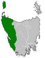
Electoral division of Murchison
Encyclopedia
Tasmanian Legislative Council
The Legislative Council, or upper house, is one of the two chambers of the Parliament of Tasmania in Australia. The other is the House of Assembly. It sits in Parliament House in the state capital, Hobart...
. It is the largest electorate in size, covering an area of 19,421 km².
It is located on the western coast of Tasmania
Tasmania
Tasmania is an Australian island and state. It is south of the continent, separated by Bass Strait. The state includes the island of Tasmania—the 26th largest island in the world—and the surrounding islands. The state has a population of 507,626 , of whom almost half reside in the greater Hobart...
and includes the municipalities of Waratah-Wynyard, West Coast
West Coast, Tasmania
The West Coast of Tasmania is the part of the state that is strongly associated with wilderness, mining and tourism, rough country and isolation...
and Circular Head
Circular Head
The Circular Head Council is a Local Government Area of Tasmania. It covers the far north-west corner of the state mainland.The major centres of the municipality are Smithton, on the north coast; Stanley, east of Smithton; and Marrawah on the west coast...
.
The electorate is named after Mount Murchison
Mount Murchison (Tasmania)
Mount Murchison is the tallest mountain in the West Coast Range Tasmania, Australia.Like most of the mountains in the West Coast Range - the taller were named after opponents or critics of Charles Darwin, the smaller after his supporters.-References:...
near Rosebery
Rosebery, Tasmania
Rosebery is a town on the west coast of Tasmania, Australia. It is situated at the northern end of the West Coast Range, in the shadow of Mount Black and adjacent to the Pieman River now Lake Pieman....
and the Murchison River which also flows through the region.
With in the boundaries of Murchison include the towns of; Queenstown
Queenstown, Tasmania
Queenstown is a town in the West Coast region of the island of Tasmania. It is located in a valley on western slopes of Mount Owen on the West Coast Range.It had a population of 5,119 people . At the 2006 census, Queenstown had a population of 2,117....
, Zeehan
Zeehan, Tasmania
Zeehan is a town on the west coast of Tasmania, Australia. It lies southwest of Burnie. At the 2006 census, Zeehan had a population of 845. It is part of the Municipality of West Coast....
, Roseberry
Rosebery, Tasmania
Rosebery is a town on the west coast of Tasmania, Australia. It is situated at the northern end of the West Coast Range, in the shadow of Mount Black and adjacent to the Pieman River now Lake Pieman....
, Wynyard
Wynyard, Tasmania
Wynyard is a rural town on the north-west coast of Tasmania, Australia. It lies west of Burnie on the Bass Highway at the mouth of the Inglis River....
, Smithton
Smithton, Tasmania
Smithton is a town in the far north-west coast of Tasmania, Australia. It lies on the Bass Highway, 85 km north-west of Burnie. At the 2006 census, Smithton had a population of 3,361. Smithton is the administrative centre of the Circular Head Council...
, Stanley
Stanley, Tasmania
Stanley is a town on the north-west coast of Tasmania, Australia. Travelling west, Stanley is the second-last major township on the north-west coast of Tasmania, Smithton being the larger township in the Circular Head municipality...
, Somerset
Somerset, Tasmania
Somerset is a small township to the west of Burnie, Tasmania, Australia. Today the city of Burnie encompasses the entire Burnie-Somerset urban area; however, the town is part of the Waratah/Wynyard municipal area.-Geography:...
, Strahan
Strahan, Tasmania
-See also:* Convicts on the West Coast of Tasmania* Macquarie Harbour* Railways on the West Coast of Tasmania* West Coast Piners-Further reading:* *...
and Waratah
Waratah, Tasmania
Waratah is a town in western Tasmania. It was constructed to support a tin mine at Mount Bischoff. The town is built at the top of a waterfall, and water was diverted from the stream to provide water for mine sluicing and processing. At the 2006 census, Waratah had a population of 227.Tin was...
.
The number of enrolled voters is 23, 473. The sitting member is Ruth Forrest
Ruth Forrest
Ruth Jane Forrest is an independent member of the Tasmanian Legislative Council in the electoral division of Murchison.Forrest was first elected in May 2005...
, who was re-elected unopposed in 2011.
Members
| Member | Party affiliation | Period | |
|---|---|---|---|
| Tony Fletcher Tony Fletcher (politician) Anthony William "Tony" Fletcher is a former Australian politician. He was an Independent member of the Tasmanian Legislative Council from 1981 to 2005, representing first Russell and then Murchison.... |
Independent Independent (politician) In politics, an independent or non-party politician is an individual not affiliated to any political party. Independents may hold a centrist viewpoint between those of major political parties, a viewpoint more extreme than any major party, or they may have a viewpoint based on issues that they do... |
1999–2005 | |
| Ruth Forrest Ruth Forrest Ruth Jane Forrest is an independent member of the Tasmanian Legislative Council in the electoral division of Murchison.Forrest was first elected in May 2005... |
Independent Independent (politician) In politics, an independent or non-party politician is an individual not affiliated to any political party. Independents may hold a centrist viewpoint between those of major political parties, a viewpoint more extreme than any major party, or they may have a viewpoint based on issues that they do... |
2005–present | |