

Edwards County, Illinois
Encyclopedia
Edwards County is a county located in the U.S. state
of Illinois
. According to the 2010 census, it has a population of 6,721, which is a decrease of 3.6% from 6,971 in 2000. Its county seat
is Albion
.
When Edwards County was formed in 1814, it comprised nearly half of the State of Illinois. New counties were formed from it until, in 1824, it assumed its present form from the creation of Wabash County
. The two are the fourth and fifth smallest counties in Illinois.
, the governor of the Illinois Territory, and, later, governor of Illinois.
Unlike most of the counties in Illinois, Edwards County is subdivided into "Road Districts", as opposed to "Townships
". Most of Illinois was surveyed according to the Land Ordinance of 1785
, which required the establishment of townships that are six miles square. Most of the counties in the State are made up of such townships. Edwards County, on the other hand, consists of Road Districts that do not generally correspond with the surveyed townships. This is a reflection of the fact that Edwards County was settled prior to the survey that established the townships.
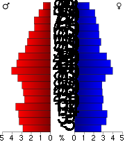
As of the census
of 2000, there were 6,971 people, 2,905 households, and 2,027 families residing in the county. The population density
was 31 people per square mile (12/km²). There were 3,199 housing units at an average density of 14 per square mile (6/km²). The racial makeup of the county was 98.87% White
, 0.14% Black
or African American
, 0.09% Native American
, 0.40% Asian
, 0.04% Pacific Islander
, 0.09% from other races
, and 0.37% from two or more races. 0.46% of the population were Hispanic
or Latino
of any race. 29.3% were of English
, 26.6% American
, 22.2% German
and 6.3% Irish
ancestry according to Census 2000. 99.1% spoke English
as their first language.
There were 2,905 households out of which 29.80% had children under the age of 18 living with them, 59.00% were married couples
living together, 8.20% had a female householder with no husband present, and 30.20% were non-families. 27.50% of all households were made up of individuals and 14.60% had someone living alone who was 65 years of age or older. The average household size was 2.37 and the average family size was 2.88.
In the county the population was spread out with 23.10% under the age of 18, 8.00% from 18 to 24, 26.10% from 25 to 44, 24.30% from 45 to 64, and 18.50% who were 65 years of age or older. The median age was 40 years. For every 100 females there were 93.80 males. For every 100 females age 18 and over, there were 91.50 males.
The median income for a household in the county was $31,816, and the median income for a family was $38,750. Males had a median income of $27,165 versus $19,579 for females. The per capita income
for the county was $16,187. About 6.30% of families and 9.80% of the population were below the poverty line, including 13.80% of those under age 18 and 8.70% of those age 65 or over.
In other positions the county has been not been consistently Republican for as long, but nevertheless has been so for many years. The last Democratic Senatorial candidate it backed was Alan J. Dixon
in 1986 and the last Democratic gubernatorial candidate it supported was Glenn Poshard
, who carried all of Southern Illinois in his failed 1998 bid. Most of the county is in Illinois's 19th congressional district, which has a Cook Partisan Voting Index
of R+9 and has been represented by John Shimkus
since 2003. The rest of the county is in Illinois's 15th congressional district, which has Cook Partisan Voting Index
of R+6 and has been represented by Republican Tim Johnson since 2001. In more local positions the county is in the 108th district of the Illinois House of Representatives
so is represented by Republican David Reis
and is in the Illinois Senate
it lies in the 54th district and is represented by Republican John O. Jones
.
U.S. state
A U.S. state is any one of the 50 federated states of the United States of America that share sovereignty with the federal government. Because of this shared sovereignty, an American is a citizen both of the federal entity and of his or her state of domicile. Four states use the official title of...
of Illinois
Illinois
Illinois is the fifth-most populous state of the United States of America, and is often noted for being a microcosm of the entire country. With Chicago in the northeast, small industrial cities and great agricultural productivity in central and northern Illinois, and natural resources like coal,...
. According to the 2010 census, it has a population of 6,721, which is a decrease of 3.6% from 6,971 in 2000. Its county seat
County seat
A county seat is an administrative center, or seat of government, for a county or civil parish. The term is primarily used in the United States....
is Albion
Albion, Illinois
Albion is a city in Edwards County, Illinois, United States. The population was 1,933 at the 2000 census. It is the county seat of Edwards County. It is the home of the most pig farmers per square mile of all of the US counties.-Geography:...
.
Geography
According to the 2010 census, the county has a total area of 222.72 square miles (576.8 km²), of which 222.42 square miles (576.1 km²) (or 99.87%) is land and 0.3 square mile (0.776996433 km²) (or 0.13%) is water.When Edwards County was formed in 1814, it comprised nearly half of the State of Illinois. New counties were formed from it until, in 1824, it assumed its present form from the creation of Wabash County
Wabash County, Illinois
Wabash County is a county located in the U.S. state of Illinois. According to the 2010 census, it has a population of 11,947, which is a decrease of 7.7% from 12,937 in 2000...
. The two are the fourth and fifth smallest counties in Illinois.
Major highways


Adjacent counties
- Richland County (north)
- Wabash CountyWabash County, IllinoisWabash County is a county located in the U.S. state of Illinois. According to the 2010 census, it has a population of 11,947, which is a decrease of 7.7% from 12,937 in 2000...
(east) - Gibson CountyGibson County, IndianaGibson County is a county located in the southwestern part of the U.S. state of Indiana and is included in the Evansville, Indiana–Kentucky Metropolitan Statistical Area. As of 2010, the population was 33,503. The county seat is Princeton.-Geography:...
, IndianaIndianaIndiana is a US state, admitted to the United States as the 19th on December 11, 1816. It is located in the Midwestern United States and Great Lakes Region. With 6,483,802 residents, the state is ranked 15th in population and 16th in population density. Indiana is ranked 38th in land area and is...
(southeast) - White CountyWhite County, IllinoisWhite County is a county located in the U.S. state of Illinois. According to the 2010 census, it has a population of 14,665, which is a decrease of 4.6% from 15,371 in 2000...
(south) - Wayne County (west)
History
Edwards County was named for Ninian EdwardsNinian Edwards
Ninian Edwards was a founding political figure of the state of Illinois. He served as the first and only governor of the Illinois Territory from 1809 to 1818, as one of the first two United States Senators from Illinois from 1818 to 1824, and as the third Governor of Illinois from 1826 to 1830...
, the governor of the Illinois Territory, and, later, governor of Illinois.
Unlike most of the counties in Illinois, Edwards County is subdivided into "Road Districts", as opposed to "Townships
Township (United States)
A township in the United States is a small geographic area. Townships range in size from 6 to 54 square miles , with being the norm.The term is used in three ways....
". Most of Illinois was surveyed according to the Land Ordinance of 1785
Land Ordinance of 1785
The Land Ordinance of 1785 was adopted by the United States Congress on May 20, 1785. Under the Articles of Confederation, Congress did not have the power to raise revenue by direct taxation of the inhabitants of the United States...
, which required the establishment of townships that are six miles square. Most of the counties in the State are made up of such townships. Edwards County, on the other hand, consists of Road Districts that do not generally correspond with the surveyed townships. This is a reflection of the fact that Edwards County was settled prior to the survey that established the townships.
Demographics
As of the census
Census
A census is the procedure of systematically acquiring and recording information about the members of a given population. It is a regularly occurring and official count of a particular population. The term is used mostly in connection with national population and housing censuses; other common...
of 2000, there were 6,971 people, 2,905 households, and 2,027 families residing in the county. The population density
Population density
Population density is a measurement of population per unit area or unit volume. It is frequently applied to living organisms, and particularly to humans...
was 31 people per square mile (12/km²). There were 3,199 housing units at an average density of 14 per square mile (6/km²). The racial makeup of the county was 98.87% White
Race (United States Census)
Race and ethnicity in the United States Census, as defined by the Federal Office of Management and Budget and the United States Census Bureau, are self-identification data items in which residents choose the race or races with which they most closely identify, and indicate whether or not they are...
, 0.14% Black
Race (United States Census)
Race and ethnicity in the United States Census, as defined by the Federal Office of Management and Budget and the United States Census Bureau, are self-identification data items in which residents choose the race or races with which they most closely identify, and indicate whether or not they are...
or African American
Race (United States Census)
Race and ethnicity in the United States Census, as defined by the Federal Office of Management and Budget and the United States Census Bureau, are self-identification data items in which residents choose the race or races with which they most closely identify, and indicate whether or not they are...
, 0.09% Native American
Race (United States Census)
Race and ethnicity in the United States Census, as defined by the Federal Office of Management and Budget and the United States Census Bureau, are self-identification data items in which residents choose the race or races with which they most closely identify, and indicate whether or not they are...
, 0.40% Asian
Race (United States Census)
Race and ethnicity in the United States Census, as defined by the Federal Office of Management and Budget and the United States Census Bureau, are self-identification data items in which residents choose the race or races with which they most closely identify, and indicate whether or not they are...
, 0.04% Pacific Islander
Race (United States Census)
Race and ethnicity in the United States Census, as defined by the Federal Office of Management and Budget and the United States Census Bureau, are self-identification data items in which residents choose the race or races with which they most closely identify, and indicate whether or not they are...
, 0.09% from other races
Race (United States Census)
Race and ethnicity in the United States Census, as defined by the Federal Office of Management and Budget and the United States Census Bureau, are self-identification data items in which residents choose the race or races with which they most closely identify, and indicate whether or not they are...
, and 0.37% from two or more races. 0.46% of the population were Hispanic
Race (United States Census)
Race and ethnicity in the United States Census, as defined by the Federal Office of Management and Budget and the United States Census Bureau, are self-identification data items in which residents choose the race or races with which they most closely identify, and indicate whether or not they are...
or Latino
Race (United States Census)
Race and ethnicity in the United States Census, as defined by the Federal Office of Management and Budget and the United States Census Bureau, are self-identification data items in which residents choose the race or races with which they most closely identify, and indicate whether or not they are...
of any race. 29.3% were of English
English people
The English are a nation and ethnic group native to England, who speak English. The English identity is of early mediaeval origin, when they were known in Old English as the Anglecynn. England is now a country of the United Kingdom, and the majority of English people in England are British Citizens...
, 26.6% American
United States
The United States of America is a federal constitutional republic comprising fifty states and a federal district...
, 22.2% German
Germans
The Germans are a Germanic ethnic group native to Central Europe. The English term Germans has referred to the German-speaking population of the Holy Roman Empire since the Late Middle Ages....
and 6.3% Irish
Irish people
The Irish people are an ethnic group who originate in Ireland, an island in northwestern Europe. Ireland has been populated for around 9,000 years , with the Irish people's earliest ancestors recorded having legends of being descended from groups such as the Nemedians, Fomorians, Fir Bolg, Tuatha...
ancestry according to Census 2000. 99.1% spoke English
English language
English is a West Germanic language that arose in the Anglo-Saxon kingdoms of England and spread into what was to become south-east Scotland under the influence of the Anglian medieval kingdom of Northumbria...
as their first language.
There were 2,905 households out of which 29.80% had children under the age of 18 living with them, 59.00% were married couples
Marriage
Marriage is a social union or legal contract between people that creates kinship. It is an institution in which interpersonal relationships, usually intimate and sexual, are acknowledged in a variety of ways, depending on the culture or subculture in which it is found...
living together, 8.20% had a female householder with no husband present, and 30.20% were non-families. 27.50% of all households were made up of individuals and 14.60% had someone living alone who was 65 years of age or older. The average household size was 2.37 and the average family size was 2.88.
In the county the population was spread out with 23.10% under the age of 18, 8.00% from 18 to 24, 26.10% from 25 to 44, 24.30% from 45 to 64, and 18.50% who were 65 years of age or older. The median age was 40 years. For every 100 females there were 93.80 males. For every 100 females age 18 and over, there were 91.50 males.
The median income for a household in the county was $31,816, and the median income for a family was $38,750. Males had a median income of $27,165 versus $19,579 for females. The per capita income
Per capita income
Per capita income or income per person is a measure of mean income within an economic aggregate, such as a country or city. It is calculated by taking a measure of all sources of income in the aggregate and dividing it by the total population...
for the county was $16,187. About 6.30% of families and 9.80% of the population were below the poverty line, including 13.80% of those under age 18 and 8.70% of those age 65 or over.
Politics
Edwards County is one of the most consistently Republican counties in the state. It has voted for the Republican candidate in all Presidential elections from 1960 to present. In the last five Presidential elections no Democratic candidate has received more than 37% of the county's vote.In other positions the county has been not been consistently Republican for as long, but nevertheless has been so for many years. The last Democratic Senatorial candidate it backed was Alan J. Dixon
Alan J. Dixon
Alan John Dixon is a Democratic politician who was elected to various Illinois state offices from 1951 to 1981 and served as United States Senator from Illinois from 1981 until 1993.-Biography:...
in 1986 and the last Democratic gubernatorial candidate it supported was Glenn Poshard
Glenn Poshard
Glenn Poshard is a former Illinois State Senator, U.S. Congressman, Gubernatorial Candidate, and is currently President of the Southern Illinois University system.-Early career:...
, who carried all of Southern Illinois in his failed 1998 bid. Most of the county is in Illinois's 19th congressional district, which has a Cook Partisan Voting Index
Cook Partisan Voting Index
The Cook Partisan Voting Index , sometimes referred to as simply the Partisan Voting Index , is a measurement of how strongly an American congressional district or state leans toward one political party compared to the nation as a whole...
of R+9 and has been represented by John Shimkus
John Shimkus
John Mondy Shimkus is the U.S. Representative for , serving since 1997. He is a member of the Republican Party....
since 2003. The rest of the county is in Illinois's 15th congressional district, which has Cook Partisan Voting Index
Cook Partisan Voting Index
The Cook Partisan Voting Index , sometimes referred to as simply the Partisan Voting Index , is a measurement of how strongly an American congressional district or state leans toward one political party compared to the nation as a whole...
of R+6 and has been represented by Republican Tim Johnson since 2001. In more local positions the county is in the 108th district of the Illinois House of Representatives
Illinois House of Representatives
The Illinois House of Representatives is the lower house of the Illinois General Assembly, the state legislature of the U.S. state of Illinois. The body was created by the first Illinois Constitution adopted in 1818. The state House of Representatives is made of 118 representatives elected from...
so is represented by Republican David Reis
David Reis
David Reis is a Republican member of the Illinois House of Representatives, representing the 108th district since 2005.David Reis grew up on his family's farm in Ste. Marie, Illinois. After working in Chicago as an executive recruiter, he returned to the farm after his father's death in 1990...
and is in the Illinois Senate
Illinois Senate
The Illinois Senate is the upper chamber of the Illinois General Assembly, the legislative branch of the government of the state of Illinois in the United States. The body was created by the first state constitution adopted in 1818. The Illinois Senate is made up of 59 senators elected from...
it lies in the 54th district and is represented by Republican John O. Jones
John O. Jones
John O. Jones is a Republican member of the Illinois Senate, representing the 54th district since 2003. Jones previously served in the Illinois House of Representatives from 1995 to 2002....
.
Villages
- Bone GapBone Gap, IllinoisBone Gap is a village in Edwards County, Illinois, United States. The population was 272 at the 2000 census.-Geography:Bone Gap is located at ....
- BrownsBrowns, IllinoisBrowns is a village in Edwards County, Illinois, United States. The 2000 census gave a total population of 175.-Geography:Browns is located at ....
- West SalemWest Salem, IllinoisWest Salem is a village in Edwards County, Illinois, United States. The population was 1,001 at the 2000 census.-Earthquake:West Salem is within the Wabash Valley seismic zone. On April 18, 2008 at 09:36:56 UTC a moderate earthquake of 5.2 magnitude was centered near the village...
Unincorporated
- BlackBlack, IllinoisBlack is an unincorporated community in Edwards County, Illinois, United States. Black is west-northwest of Bone Gap....
- ElleryEllery, IllinoisEllery is an unincorporated community on the border of Edwards and Wayne Counties in the U.S. state of Illinois. The eastern side lies in Edwards and the west side in Wayne; the county line runs down the main street.-History:...
- SamsvilleSamsville, IllinoisSamsville is an unincorporated community in northern Edwards County, Illinois, United States. Samsville is located on Illinois Route 130.-History:...
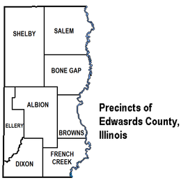
Precincts
- AlbionAlbion Precinct, Edwards County, IllinoisThe Albion Precinct is a now-defunct precinct in Edwards County, Illinois. It was home to Albion, Illinois, the county's seat. Albion Precinct was split up into Albion No. 1 Precinct, Albion No. 2 Precinct, and Albion No. 3 Precinct.-External links:...
- Albion No. 1
- Albion No. 2
- Albion No. 3
- Bone Gap
- Browns
- Dixon
- Ellery
- French CreekFrench Creek Precinct, Edwards County, IllinoisFrench Creek Precinct is one of the 12 precincts of Edwards County, Illinois. Grayville, Illinois is the precinct seat....
- Salem
- Salem No. 1
- Salem No. 2
- Shelby
- Shelby No. 1
- Shelby No. 2