
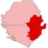
Eastern Province, Sierra Leone
Encyclopedia

Sierra Leone
Sierra Leone , officially the Republic of Sierra Leone, is a country in West Africa. It is bordered by Guinea to the north and east, Liberia to the southeast, and the Atlantic Ocean to the west and southwest. Sierra Leone covers a total area of and has an estimated population between 5.4 and 6.4...
. It covers an area of 15,553 km² and has a population of 1,187,532 (2004 census
Census
A census is the procedure of systematically acquiring and recording information about the members of a given population. It is a regularly occurring and official count of a particular population. The term is used mostly in connection with national population and housing censuses; other common...
). Its capital and administrative center is Kenema
Kenema
Kenema is the third largest city in Sierra Leone and the largest city in the Eastern Province with a population of 128,402 in the 2004 census and a more recent estimate of 169,937...
.
Eastern Province, Sierra Leone is very mountainous and has two ranges, the Gola Hills and the Loma Mountains
Districts
The province is divided into 3 districts.- Kailahun DistrictKailahun DistrictKailahun District is a district in the Eastern Province of Sierra Leone. Its capital and largest city is Kailahun. The other major towns in the district include Segbwema, Koindu, Pendembu and Daru. As of 2010, the district has a population of 395,957 ....
, capital KailahunKailahunKailahun is the capital of Kailahun District in the Eastern Province of Sierra Leone. The town lies 300 miles east of Freetown and with a population of 25,210. The population of Kailahun is largely from the Mende ethnic group and the Mende language along with the Krio language are widely spoken... - Kenema DistrictKenema DistrictKenema District is a district in the Eastern Province of Sierra Leone. Its capital and largest city is Kenema, which is also the third largest city in Sierra Leone. The other major towns in the district include Tongo and Blama. The district is the most populous district in the Eastern province with...
, capital KenemaKenemaKenema is the third largest city in Sierra Leone and the largest city in the Eastern Province with a population of 128,402 in the 2004 census and a more recent estimate of 169,937... - Kono DistrictKono DistrictKono District is a district in the Eastern Province of Sierra Leone. Its capital and largest city is Koidu Town. The other major towns in the district include Yengema, Tombodu, Motema, Jaiama-Nimokoro and Sewafe. Kono District is the largest diamond producer in Sierra Leone.The population of Kono...
, capital Koidu Town
Borders
Eastern Province has the following borders:- Nzérékoré RegionNzérékoré RegionThe Nzérékoré Region is a region in the southern part of Guinea. Its capital and largest city is Nzérékoré. It is one of the eight regions of Guinea...
, GuineaGuineaGuinea , officially the Republic of Guinea , is a country in West Africa. Formerly known as French Guinea , it is today sometimes called Guinea-Conakry to distinguish it from its neighbour Guinea-Bissau. Guinea is divided into eight administrative regions and subdivided into thirty-three prefectures...
: northeast - Lofa CountyLofa CountyLofa is a county in the northernmost portion of the West African nation of Liberia. One of 15 counties that comprise the first-level of administrative division in the nation, it has six districts. Voinjama serves as the capital with the area of the county measuring...
, LiberiaLiberiaLiberia , officially the Republic of Liberia, is a country in West Africa. It is bordered by Sierra Leone on the west, Guinea on the north and Côte d'Ivoire on the east. Liberia's coastline is composed of mostly mangrove forests while the more sparsely populated inland consists of forests that open...
: east - Gbarpolu CountyGbarpolu CountyGbarpolu is a county in the northern portion of the West African nation of Liberia. One of 15 counties that comprise the first-level of administrative division in the nation, it has six districts. Bopulu serves as the capital with the area of the county measuring...
, LiberiaLiberiaLiberia , officially the Republic of Liberia, is a country in West Africa. It is bordered by Sierra Leone on the west, Guinea on the north and Côte d'Ivoire on the east. Liberia's coastline is composed of mostly mangrove forests while the more sparsely populated inland consists of forests that open...
: southeast - Grand Cape Mount CountyGrand Cape Mount CountyGrand Cape Mount is a county in the northwestern portion of the West African nation of Liberia. One of 15 counties that comprise the first-level of administrative division in the nation, it has five districts. Robertsport serves as the capital with the area of the county measuring...
, LiberiaLiberiaLiberia , officially the Republic of Liberia, is a country in West Africa. It is bordered by Sierra Leone on the west, Guinea on the north and Côte d'Ivoire on the east. Liberia's coastline is composed of mostly mangrove forests while the more sparsely populated inland consists of forests that open...
: south - Southern ProvinceSouthern Province, Sierra LeoneThe Southern Province is one of three provinces of Sierra Leone. It covers an area of 19,694 km² and has a population of 1,377,067 . It consists of four districts . Its capital and administrative center is Bo, which is also the second largest and second most populated city in Sierra Leone...
: west - Northern ProvinceNorthern Province, Sierra LeoneThe Northern Province is one of the four provincial divisions of Sierra Leone. It comprises five Districts and covers an area of 35,936 km² and with a population of 1,718,240 . Its administrative and economic center is Makeni...
: northwest
Eastern Province is the only region of Sierra Leone without any shoreline.