

East Tremont, Bronx
Encyclopedia
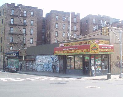
East Tremont is a low income residential neighborhood geographically located in the west Bronx
The Bronx
The Bronx is the northernmost of the five boroughs of New York City. It is also known as Bronx County, the last of the 62 counties of New York State to be incorporated...
, New York City
New York City
New York is the most populous city in the United States and the center of the New York Metropolitan Area, one of the most populous metropolitan areas in the world. New York exerts a significant impact upon global commerce, finance, media, art, fashion, research, technology, education, and...
. The neighborhood is part of Bronx Community Board 6
Bronx Community Board 6
Bronx Community Board 6 is a local government unit of the city of New York, encompassing the neighborhoods of Bathgate, Belmont, East Tremont, and West Farms...
. Its boundaries, starting from the north and moving clockwise are: East 183rd Street to the north, Crotona Avenue to the east, the Cross-Bronx Expressway
Cross-Bronx Expressway
The Cross Bronx Expressway is a major expressway in the New York City borough of the Bronx, conceived by Robert Moses and built between 1948 and 1972. It carries traffic on Interstate 95 through the city, and serves as a portion of Interstate 295 toward Long Island; a portion is also designated U.S...
to the south, and the Webster Avenue to the west. East Tremont Avenue is the primary thoroughfare through East Tremont. ZIP codes include 10457, 10458, and 10460. The area is patrolled by the 48th Precinct located at 450 Cross Bronx Expressway. New York City Housing Authority
New York City Housing Authority
The New York City Housing Authority provides public housing for low- and moderate-income residents throughout the five boroughs of New York City. NYCHA also administers a citywide Section 8 Leased Housing Program in rental apartments...
property in the area is patrolled by P.S.A. 8 at 2794 Randall Avenue in the Throggs Neck section of the Bronx.
Demographics
East Tremont has a population over 30,000. For decades East Tremont has been one of the poorest communities in America. Its steady decline began in the 1950s largely as a result of the displacement of working- and lower-middle class, largely of Jewish descent, residents by the destructive construction of the Cross-Bronx Expressway. Over half the population lives below the poverty line and receives public assistance (AFDC, Home Relief, Supplemental Security Income, and Medicaid). East Tremont has one of the highest concentrations of Puerto Ricans in all of New York City. There is a small but growing DominicanDominican Republic
The Dominican Republic is a nation on the island of La Hispaniola, part of the Greater Antilles archipelago in the Caribbean region. The western third of the island is occupied by the nation of Haiti, making Hispaniola one of two Caribbean islands that are shared by two countries...
population. The vast majority of households are renter occupied.
Land use and terrain
East Tremont is dominated by 5- and 6-story tenement buildings, older multi-unit homes, vacant lots, and newly constructed multi-unit townhouses and apartment buildings. Most of the original housing stock was structurally damaged by arson and eventually razed by the city. The total land area is less than one square mile. The terrain is somewhat hilly.Low income public housing projects
- There are two NYCHA developments located in East Tremont.
- Twin roads East (Site 9); one, 14-story building.
- East 180th Street-Monterey Avenue; one, 10-story building.
Public
- PS/MS 3: Raul Julia (East 180th St and LaFontaine Av)
- PS 23: Early Childhood (East 181st St and Washington Av)
- PS 32: Belmont (East 183rd St and Belmont Av)
- PS 44: David Farragut (East 176th St and Prospect Av)
- PS 57: Crescent/Frederick Douglass Academy V (East 180th St and Crotona Av)
- PS 58: Tremont Park (East 176th St and Washington Av)
- PS 59: Bathgate (East 182nd St and Bathgate Av)
- PS 92: (East 179th St and Clinton Av)
- PS/MS 211: Bilingual (Fairmount Place and Prospect Av)
- PS 300/MS 129: Twin Parks (East 180th St and Mapes Av)
- MS 118: William J. Niles (East 179th St and Arthur Av)
Transportation
- Bx15: to Fordham PlazaFordham (Metro-North station)The Fordham Metro-North Railroad station serves the residents of the Fordham neighborhood of the Bronx, New York via the Harlem Line and New Haven Line. It is the only Harlem Line stop in the Bronx that is an express station. It is 8.9 miles from Grand Central Terminal...
or West Harlem (via Third Avenue) - Bx17: to Fordham PlazaFordham (Metro-North station)The Fordham Metro-North Railroad station serves the residents of the Fordham neighborhood of the Bronx, New York via the Harlem Line and New Haven Line. It is the only Harlem Line stop in the Bronx that is an express station. It is 8.9 miles from Grand Central Terminal...
or Port MorrisPort Morris, BronxPort Morris is a neighborhood in the southwest Bronx, New York City. It is a heavily industrial neighborhood. Its boundaries are the Major Deegan Expressway and Bruckner Expressway to the north, East 149th Street to the east, the East River to the southeast, the Bronx Kill south, and the Harlem...
(via Crotona-Prospect Avenues) - Bx19: to New York Botanical Gardens or Riverbank State ParkRiverbank State ParkRiverbank State Park is a park built on the top of a sewage treatment facility on the Hudson River, in the New York City borough of Manhattan....
(via Southern Boulevard-East 149th Street) - Bx36: to Castle HillCastle Hill, BronxCastle Hill is primarily a residential neighborhood geographically located in the South Central section of the borough of The Bronx in New York City. The neighborhood is part of Bronx Community Board 9...
or George Washington Bridge Bus TerminalGeorge Washington Bridge Bus TerminalThe George Washington Bridge Bus Station is a commuter bus terminal located at the east end of the George Washington Bridge in the Washington Heights area of Manhattan in New York City, New York....
(via East 180th Street) - Bx40: to SUNY Maritime College or Morris HeightsMorris Heights, BronxMorris Heights is a low income residential neighborhood located in the west Bronx. The neighborhood is part of Bronx Community Board 5. Its boundaries, starting from the north and moving clockwise are: West Burnside Avenue to the north, Jerome Avenue to the east, the Cross-Bronx Expressway to the...
(via Tremont-Burnside Avenues) - Bx41: to Wakefield-241st Street stationWakefield-241st Street (IRT White Plains Road Line)Wakefield – 241st Street is a terminal station on the IRT White Plains Road Line of the New York City Subway. Located at the intersection of 241st Street and White Plains Road in the Wakefield neighborhood of the Bronx, it is served by the 2 train at all times and the only station on the 2 that is...
or 3rd Av-149th Street station (via Webster Avenue) - Bx42: to Throggs Neck or Morris HeightsMorris Heights, BronxMorris Heights is a low income residential neighborhood located in the west Bronx. The neighborhood is part of Bronx Community Board 5. Its boundaries, starting from the north and moving clockwise are: West Burnside Avenue to the north, Jerome Avenue to the east, the Cross-Bronx Expressway to the...
(via Tremont-Burnside Avenues) - Bx55: to Gun Hill Road stationGun Hill Road (IRT White Plains Road Line)Gun Hill Road is an express station on the IRT White Plains Road Line of the New York City Subway. Located in the Bronx at the intersection of Gun Hill and White Plains Roads, it is served by the 2 train at all times while the 5 train provides additional rush hour service in the peak direction.This...
or 3rd Av-149th Street station (via Third Avenue, Limited) - Tremont (Metro-North station)Tremont (Metro-North station)The Tremont Metro-North Railroad station serves the Tremont section of The Bronx via the Harlem Line. It is 7.9 miles from Grand Central Terminal and is in an open cut at the intersection of Park Avenue and East Tremont Avenue...
Facts
- East Tremont is often considered part of the socioeconomic South BronxSouth BronxThe South Bronx is an area of the New York City borough of The Bronx. The neighborhoods of Tremont, University Heights, Highbridge, Morrisania, Soundview, Hunts Point, and Castle Hill are sometimes considered part of the South Bronx....
. - St. Barnabas Hospital forms the border between East Tremont and neighboring BelmontBelmont, BronxBelmont is a residential neighborhood geographically located in the west Bronx. The neighborhood is part of Bronx Community Board 6. Its boundaries, starting from the north and moving clockwise are: Fordham Road to the north, Bronx Park to the east, East 183rd Street to the south, and the Third...
. It is on East 183rd Street and 3rd Avenue.