
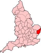
East Suffolk
Encyclopedia
East Suffolk, along with West Suffolk
, was created in 1888 as an administrative county
of England
. The administrative county was based on the eastern quarter sessions
division of Suffolk. East Suffolk County Council's headquarters was in Ipswich
, which was a county borough
in its own right.
East Suffolk was abolished in 1974 when most of the county was merged with West Suffolk
and the county borough
of Ipswich
to form the non-metropolitan county of Suffolk
. A small part of East Suffolk was included into Norfolk
in 1974.
s, urban district
s and rural district
s:
The rural districts were further subdivided into civil parishes.
West Suffolk
West Suffolk was an administrative county of England created in 1889 from part of the county of Suffolk. It survived until 1974 when it was rejoined with East Suffolk. Its county town was Bury St Edmunds....
, was created in 1888 as an administrative county
Administrative county
An administrative county was an administrative division in England and Wales and Ireland used for the purposes of local government. They are now abolished, although in Northern Ireland their former areas are used as the basis for lieutenancy....
of England
England
England is a country that is part of the United Kingdom. It shares land borders with Scotland to the north and Wales to the west; the Irish Sea is to the north west, the Celtic Sea to the south west, with the North Sea to the east and the English Channel to the south separating it from continental...
. The administrative county was based on the eastern quarter sessions
Quarter Sessions
The Courts of Quarter Sessions or Quarter Sessions were local courts traditionally held at four set times each year in the United Kingdom and other countries in the former British Empire...
division of Suffolk. East Suffolk County Council's headquarters was in Ipswich
Ipswich
Ipswich is a large town and a non-metropolitan district. It is the county town of Suffolk, England. Ipswich is located on the estuary of the River Orwell...
, which was a county borough
County borough
County borough is a term introduced in 1889 in the United Kingdom of Great Britain and Ireland , to refer to a borough or a city independent of county council control. They were abolished by the Local Government Act 1972 in England and Wales, but continue in use for lieutenancy and shrievalty in...
in its own right.
East Suffolk was abolished in 1974 when most of the county was merged with West Suffolk
West Suffolk
West Suffolk was an administrative county of England created in 1889 from part of the county of Suffolk. It survived until 1974 when it was rejoined with East Suffolk. Its county town was Bury St Edmunds....
and the county borough
County borough
County borough is a term introduced in 1889 in the United Kingdom of Great Britain and Ireland , to refer to a borough or a city independent of county council control. They were abolished by the Local Government Act 1972 in England and Wales, but continue in use for lieutenancy and shrievalty in...
of Ipswich
Ipswich
Ipswich is a large town and a non-metropolitan district. It is the county town of Suffolk, England. Ipswich is located on the estuary of the River Orwell...
to form the non-metropolitan county of Suffolk
Suffolk
Suffolk is a non-metropolitan county of historic origin in East Anglia, England. It has borders with Norfolk to the north, Cambridgeshire to the west and Essex to the south. The North Sea lies to the east...
. A small part of East Suffolk was included into Norfolk
Norfolk
Norfolk is a low-lying county in the East of England. It has borders with Lincolnshire to the west, Cambridgeshire to the west and southwest and Suffolk to the south. Its northern and eastern boundaries are the North Sea coast and to the north-west the county is bordered by The Wash. The county...
in 1974.
Subdivisions
From 1894 the administrative county was divided into municipal boroughMunicipal borough
Municipal boroughs were a type of local government district which existed in England and Wales between 1835 and 1974, in Northern Ireland from 1840 to 1973 and in the Republic of Ireland from 1840 to 2002...
s, urban district
Urban district
In the England, Wales and Ireland, an urban district was a type of local government district that covered an urbanised area. Urban districts had an elected Urban District Council , which shared local government responsibilities with a county council....
s and rural district
Rural district
Rural districts were a type of local government area – now superseded – established at the end of the 19th century in England, Wales, and Ireland for the administration of predominantly rural areas at a level lower than that of the administrative counties.-England and Wales:In England...
s:
- Boroughs: AldeburghAldeburghAldeburgh is a coastal town in Suffolk, East Anglia, England. Located on the River Alde, the town is notable for its Blue Flag shingle beach and fisherman huts where freshly caught fish are sold daily, and the Aldeburgh Yacht Club...
, BecclesBecclesBeccles is a market town and civil parish in the Waveney District of the English county of Suffolk. The town is shown on the milestone as from London via the A145 Blythburgh and A12 road, northeast of London as the crow flies, southeast of Norwich, and north northeast of the county town of...
, EyeEye, SuffolkEye is a small market town in the county of Suffolk, East Anglia, England, south of Diss, and on the River Dove.Eye is twinned with the town of Pouzauges in the Vendée Departement of France.-History:An island...
, LowestoftLowestoftLowestoft is a town in the English county of Suffolk. The town is on the North Sea coast and is the most easterly point of the United Kingdom. It is north-east of London, north-east of Ipswich and south-east of Norwich...
, SouthwoldSouthwoldSouthwold is a town on the North Sea coast, in the Waveney district of the English county of Suffolk. It is located on the North Sea coast at the mouth of the River Blyth within the Suffolk Coast and Heaths Area of Outstanding Natural Beauty. The town is around south of Lowestoft and north-east... - Urban districts: BungayBungay, SuffolkBungay is a market town in the English county of Suffolk. It lies in the Waveney valley, west of Beccles on the edge of The Broads, and at the neck of a meander of the River Waveney.-Early history:...
(created 1910), Felixstowe and Walton, (renamed FelixstoweFelixstoweFelixstowe is a seaside town on the North Sea coast of Suffolk, England. The town gives its name to the nearby Port of Felixstowe, which is the largest container port in the United Kingdom and is owned by Hutchinson Ports UK...
1914), HalesworthHalesworthHalesworth is a small market town in the northeastern corner of Suffolk, England. It is located south west of Lowestoft, and straddles the River Blyth, 9 miles upstream from Southwold. The town is served by Halesworth railway station on the Ipswich-Lowestoft East Suffolk Line...
(created 1900), Leiston-cum-Sizewell (created 1895), Oulton BroadOulton BroadOulton Broad refers to both the lake and the suburb of Lowestoft in Suffolk, England located 2 miles west of the centre of the town.-Oulton Broad:...
(created 1904, abolished 1919), SaxmundhamSaxmundhamSaxmundham is a small market town in Suffolk, England. It is set in the valley of the River Fromus, a tributary of the River Alde, approximately northeast of Ipswich and west of the coast at Sizewell. The town is bypassed by the A12 and is served by Saxmundham railway station on the East Suffolk...
(created 1900), StowmarketStowmarket-See also:* Stowmarket Town F.C.* Stowmarket High School-External links:* * * * *... - Rural districts created in 1894: Blything, Bosmere and Claydon, East StowEast Stow Rural DistrictEast Stow was a rural district in East Suffolk, England from 1894 to 1934.It was created under the Local Government Act 1894, from the part of the Stow rural sanitary district that was in East Suffolk It was abolished in 1934 under a County Review Order...
, HartismereHartismere Rural DistrictHartismere Rural District was a rural district in the county of East Suffolk, England. It was expanded in 1934 by merging with the disbanded Hoxne Rural District with a slight readjustment of boundaries...
, Hoxne, Mutford and Lothingland, Plomesgate, Samford, Wangford, Woodbridge- The Rural Districts were completely reorganised by a County Review OrderLocal Government Act 1929The Local Government Act 1929 was an Act of the Parliament of the United Kingdom that made changes to the Poor Law and local government in England and Wales....
in 1934, and reduced to seven in number: Blyth, DebenDeben Rural DistrictDeben Rural District was a rural district in the county of East Suffolk, England. It was created in 1934 by the merger of parts ofthe disbanded Bosemere and Claydon Rural District, the disbanded Plomesgate Rural District and the disbanded Woodbridge Rural District, under a County Review Order.It...
, GippingGipping Rural DistrictGipping Rural District was a rural district in the county of East Suffolk, England. It was created in 1934 by the merger of the disbanded Bosemere and Claydon Rural District and the disbanded East Stow Rural District, under a County Review Order....
, HartismereHartismere Rural DistrictHartismere Rural District was a rural district in the county of East Suffolk, England. It was expanded in 1934 by merging with the disbanded Hoxne Rural District with a slight readjustment of boundaries...
, LothinglandLothingland Rural DistrictLothingland was a rural district in East Suffolk, England, named after the ancient half-hundred of Lothingland which was merged with Mutford half-hundred in 1763 to form Mutford and Lothingland....
, Samford, Wainford
- The Rural Districts were completely reorganised by a County Review Order
The rural districts were further subdivided into civil parishes.