

East Kowloon Corridor
Encyclopedia
Highway
A highway is any public road. In American English, the term is common and almost always designates major roads. In British English, the term designates any road open to the public. Any interconnected set of highways can be variously referred to as a "highway system", a "highway network", or a...
in Kowloon
Kowloon
Kowloon is an urban area in Hong Kong comprising the Kowloon Peninsula and New Kowloon. It is bordered by the Lei Yue Mun strait in the east, Mei Foo Sun Chuen and Stonecutter's Island in the west, Tate's Cairn and Lion Rock in the north, and Victoria Harbour in the south. It had a population of...
, Hong Kong
Hong Kong
Hong Kong is one of two Special Administrative Regions of the People's Republic of China , the other being Macau. A city-state situated on China's south coast and enclosed by the Pearl River Delta and South China Sea, it is renowned for its expansive skyline and deep natural harbour...
. It is part of Route 5
Route 5 (Hong Kong)
Route 5 is a route artery in Hong Kong from eastern to western Kowloon and New Kowloon, and ends in Tsuen Wan in the New Territories, linking Route 9....
. It is a dual two-lane carriageway running from the exit of Kai Tak Tunnel
Kai Tak Tunnel
Kai Tak Tunnel , formerly known as the Airport Tunnel is a tunnel in New Kowloon, Hong Kong, which connects the Kowloon Bay and To Kwa Wan areas by going beneath the former Hong Kong International Airport . It is part of Route 5...
near Sung Wong Toi Road to its junction with Ma Tau Wai Road in Hung Hom
Hung Hom
Hung Hom is an area of Kowloon, in Hong Kong, administratively part of the Kowloon City District, with a portion west of the railway in the Yau Tsim Mong District. Hung Hom serves mainly residential purposes though is mixed with some industrial buildings in the north.-Geography:Hung Hom is located...
, where both roads are succeeded by Chatham Road.
Function
Since its completion in 1981, East Kowloon Corridor, together with Kai Tak Tunnel, play crucial roles in diverting road traffic in Kowloon by feeding traffic between Hung Hom and Kwun TongKwun Tong
Kwun Tong is an area in Kwun Tong District, situated at the eastern part of the Kowloon Peninsula, and its boundary stretches from Lion Rock in the north to Lei Yue Mun in the south, and from the winding paths of Kowloon Peak in the east to the north coast of the former Kai Tak Airport runway in...
by providing a shortcut, thereby avoiding causing traffic congestion
Traffic congestion
Traffic congestion is a condition on road networks that occurs as use increases, and is characterized by slower speeds, longer trip times, and increased vehicular queueing. The most common example is the physical use of roads by vehicles. When traffic demand is great enough that the interaction...
in To Kwa Wan
To Kwa Wan
To Kwa Wan is a bay and an area of the eastern shore of Kowloon peninsula of Hong Kong. The area is part of urban Hong Kong, and is adjacent to Hok Yuen, Hung Hom, Ma Tau Wai and Ma Tau Kok...
, Mong Kok
Mong Kok
Mong Kok , less often known as Argyle , is an area in the Yau Tsim Mong District on Kowloon Peninsula, Hong Kong...
, Kowloon City
Kowloon City
Kowloon City is an area in Kowloon, Hong Kong. It is named after the Kowloon Walled City, and is administratively part of Kowloon City District....
and Ngau Chi Wan
Ngau Chi Wan
Ngau Chi Wan was a bay beneath Hammer Hill in New Kowloon, Hong Kong. Its geographical coordinates are 22° 20' 0" North, 114° 12' 0" East. It now refers to an area north of Choi Hung Estate....
where traffic is already saturated. In particular, East Kowloon Corridor gives drivers an alternative overpass
Overpass
An overpass is a bridge, road, railway or similar structure that crosses over another road or railway...
between Hung Hom and Kowloon City. In this sense, East Kowloon Corridor serves as an ideal alternative for drivers since it has only two exits and no traffic light
Traffic light
Traffic lights, which may also be known as stoplights, traffic lamps, traffic signals, signal lights, robots or semaphore, are signalling devices positioned at road intersections, pedestrian crossings and other locations to control competing flows of traffic...
s.
Location
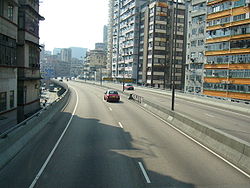
Geographically, East Kowloon Corridor runs on top of Kowloon City Road and Ma Tau Wai Road. Just ahead of the entrance to Kai Tak Tunnel lies the only branching exit of East Kowloon Corridor, which goes to Kowloon City Road northbound from the northbound direction, San Shan Road eastbound from the southbound direction, and the only branching entrance to the southbound direction fed from San Shan Road westbound. It descends and joins into Chatham Road North near an intersection with Fat Kwong Street.Although the road is named East Kowloon Corridor, it is administratively located in West Kowloon District. The word "East" is used in order to disambiguate from West Kowloon Corridor
West Kowloon Corridor
West Kowloon Corridor is part of Route 5 in Hong Kong. Bypassing existing surface roads in West Kowloon, it connects Lai Chi Kok Road in Cheung Sha Wan with the Gascoigne Road Flyover near Yau Ma Tei.The highway was built in 4 phases:...
, which is situated farther west near Lai Chi Kok
Lai Chi Kok
Lai Chi Kok is a neighborhood in New Kowloon, Hong Kong, east of Kwai Chung and west of Cheung Sha Wan. Mei Foo Sun Chuen is the largest housing estate in the area. Administratively, it belongs to the Sham Shui Po District.-History:...
. Moreover, in the early colonial days
Colonial Hong Kong
In the 19th century the British, Dutch, French, Indians and Americans saw Imperial China as the world's largest untapped market. In 1840 the British Empire launched their first and one of the most aggressive expeditionary forces to claim the territory that would later be known as Hong Kong.In a few...
, To Kwa Wan and Hung Hom both lied in the eastern half of Kowloon Peninsula
Kowloon Peninsula
The Kowloon Peninsula is a peninsula that forms the southern part of the main landmass in the territory of Hong Kong. The Kowloon Peninsula and the area of New Kowloon are collectively known as Kowloon....
, and the area now known as East Kowloon was part of New Kowloon
New Kowloon
New Kowloon is an area in Kowloon, Hong Kong, bounded in the south by Boundary Street, and in the north by the ranges of the Lion Rock, Beacon Hill, Tate's Cairn and Kowloon Peak...
. However, the entire peninsula is now integrated into West Kowloon District.
Effect on surroundings
As many buildings were already built around Kowloon City Road and Ma Tau Wai Road before East Kowloon Corridor was constructed, residents in the district, especially those living in lower floors of buildings on the sides of the flyover, were strongly affected by the noise generated from car engines during rush hourRush hour
A rush hour or peak hour is a part of the day during which traffic congestion on roads and crowding on public transport is at its highest. Normally, this happens twice a day—once in the morning and once in the evening, the times during when the most people commute...
. Many residents have already moved out from those buildings and the buildings were turned into commercial or other uses.