
East Hertfordshire
Encyclopedia
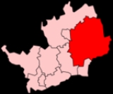
East Hertfordshire is a local government district
in Hertfordshire
, England
. Its council
has offices in Bishop's Stortford
and Hertford
(Hertfordshire's traditional county town
).
The other main towns in the district are Ware (on the River Lea), Buntingford
(on the River Rib
), and Sawbridgeworth
(on the River Stort
). Of these five major towns, all except Buntingford fall within the parliamentary constituency of Hertford and Stortford
. Buntingford is part of the North East Hertfordshire
constituency.
East Herts, as its council is officially known, is bordered by North Hertfordshire
, Stevenage
, Welwyn Hatfield
, and Broxbourne
in Hertfordshire, and by Epping Forest
, Harlow
, and Uttlesford
in Essex
.
The district was formed on 1 April 1974, as a merger of the municipal borough
of Hertford with Bishop's Stortford
, Sawbridgeworth
and Ware urban district
s, and Braughing Rural District
, Ware Rural District and part of Hertford Rural District
. By area it is the largest of the ten local government districts in Hertfordshire.
In the 2006 edition of the Channel 4
"Best and Worst Places to Live in the UK", East Hertfordshire was rated the seventh best district to live in.
at Bishop's Stortford. The major roads within the district include:
A414 - running West-East from Welwyn to Harlow, through Hertford, where it forms the Hertford by-pass.
A10 - running North-South from Broxbourne towards Cambridge.
A602 - running South East to North West, connecting Ware with Stevenage.
A120 - running West-East connecting the A10 at Standon with the M11 at Bishop's Stortford.
None of the above roads are classified as trunk roads. Therefore they are maintained by Hertfordshire County Council
while responsibility for the M11 rests with the Highways Agency
.
Stansted Airport is just beyond the edge of the district near Bishop's Stortford, but officially sits within Uttlesford district in neighbouring Essex. Many of the district's towns have rail services into London at King's Cross, Moorgate
, and Liverpool Street
.
, which has a research and maufacturing centre in Ware. The company also has large offices in neighbouring Stevenage and Harlow.
Non-metropolitan district
Non-metropolitan districts, or colloquially shire districts, are a type of local government district in England. As created, they are sub-divisions of non-metropolitan counties in a so-called "two-tier" arrangement...
in Hertfordshire
Hertfordshire
Hertfordshire is a ceremonial and non-metropolitan county in the East region of England. The county town is Hertford.The county is one of the Home Counties and lies inland, bordered by Greater London , Buckinghamshire , Bedfordshire , Cambridgeshire and...
, England
England
England is a country that is part of the United Kingdom. It shares land borders with Scotland to the north and Wales to the west; the Irish Sea is to the north west, the Celtic Sea to the south west, with the North Sea to the east and the English Channel to the south separating it from continental...
. Its council
East Hertfordshire District Council
East Hertfordshire District Council is the local authority for the East Hertfordshire non-metropolitan district of England, the United Kingdom. East Hertfordshire covers most of the eastern third of Hertfordshire, in the East of England region...
has offices in Bishop's Stortford
Bishop's Stortford
Bishop's Stortford is a historic market town and civil parish in the district of East Hertfordshire in the county of Hertfordshire in England. It is situated just west of the M11 motorway, on the county boundary with Essex and is the closest large town to London Stansted Airport and part of the...
and Hertford
Hertford
Hertford is the county town of Hertfordshire, England, and is also a civil parish in the East Hertfordshire district of the county. Forming a civil parish, the 2001 census put the population of Hertford at about 24,180. Recent estimates are that it is now around 28,000...
(Hertfordshire's traditional county town
County town
A county town is a county's administrative centre in the United Kingdom or Ireland. County towns are usually the location of administrative or judicial functions, or established over time as the de facto main town of a county. The concept of a county town eventually became detached from its...
).
The other main towns in the district are Ware (on the River Lea), Buntingford
Buntingford
Buntingford is a small market town and civil parish in the district of East Hertfordshire and county of Hertfordshire in England. It lies on the River Rib and on the Roman road Ermine Street. As a result of its location, it grew mainly as a staging post with many coaching inns and has an 18th...
(on the River Rib
River Rib
The River Rib originates near the East Hertfordshire village of Buckland and runs parallel with the A10 through Buntingford, Westmill, Braughing, Puckeridge and Standon until it reaches its confluence with the River Lea near Hertford.-History:...
), and Sawbridgeworth
Sawbridgeworth
Sawbridgeworth is a small, mainly residential, town and also a civil parish in Hertfordshire, England.- Location :Sawbridgeworth is four miles south of Bishop's Stortford, twelve miles east of Hertford and nine miles north of Epping. It lies on the A1184 and has a railway station that links to...
(on the River Stort
Stort Navigation
The Stort Navigation is the canalised section of the River Stort running from the town of Bishop's Stortford, Hertfordshire downstream to its confluence with the River Lee Navigation at Feildes Weir near Rye House, Hoddesdon, Hertfordshire.-History:...
). Of these five major towns, all except Buntingford fall within the parliamentary constituency of Hertford and Stortford
Hertford and Stortford
Hertford and Stortford is a county constituency represented in the House of Commons of the Parliament of the United Kingdom. It elects one Member of Parliament by the first past the post system of election.-Boundaries:...
. Buntingford is part of the North East Hertfordshire
North East Hertfordshire
North East Hertfordshire is a county constituency represented in the House of Commons of the Parliament of the United Kingdom. It elects one Member of Parliament by the first past the post system of election.- Boundaries :...
constituency.
East Herts, as its council is officially known, is bordered by North Hertfordshire
North Hertfordshire
North Hertfordshire is a local government district in Hertfordshire, England. Its council is based in Letchworth.The district was formed on 1 April 1974 by the amalgamation of the urban districts of Baldock, Hitchin, Letchworth, and Royston and the Hitchin Rural District.From eastward clockwise,...
, Stevenage
Stevenage
Stevenage is a town and borough in Hertfordshire, England. It is situated to the east of junctions 7 and 8 of the A1, and is between Letchworth Garden City to the north, and Welwyn Garden City to the south....
, Welwyn Hatfield
Welwyn Hatfield
The Borough of Welwyn Hatfield is a local government district in southern Hertfordshire, England.Its covers the two towns of Welwyn Garden City and Hatfield, along with numerous smaller settlements from Woolmer Green in the north to Little Heath in the south. Each of the towns has a railway station...
, and Broxbourne
Broxbourne (borough)
Broxbourne is a local government district and borough in Hertfordshire, England. Its council is based in Cheshunt, other towns include Broxbourne, Hoddesdon and Waltham Cross. The eastern boundary of the district is the River Lea...
in Hertfordshire, and by Epping Forest
Epping Forest (district)
Epping Forest is a local government district of the county of Essex, England. It is named after Epping Forest, of which the district contains a large part...
, Harlow
Harlow
Harlow is a new town and local government district in Essex, England. It is located in the west of the county and on the border with Hertfordshire, on the Stort Valley, The town is near the M11 motorway and forms part of the London commuter belt.The district has a current population of 78,889...
, and Uttlesford
Uttlesford
Uttlesford is a local government district in Essex, England. Its council is based in Saffron Walden.Its name is derived from the ancient Hundred of the same name....
in Essex
Essex
Essex is a ceremonial and non-metropolitan county in the East region of England, and one of the home counties. It is located to the northeast of Greater London. It borders with Cambridgeshire and Suffolk to the north, Hertfordshire to the west, Kent to the South and London to the south west...
.
The district was formed on 1 April 1974, as a merger of the municipal borough
Municipal borough
Municipal boroughs were a type of local government district which existed in England and Wales between 1835 and 1974, in Northern Ireland from 1840 to 1973 and in the Republic of Ireland from 1840 to 2002...
of Hertford with Bishop's Stortford
Bishop's Stortford
Bishop's Stortford is a historic market town and civil parish in the district of East Hertfordshire in the county of Hertfordshire in England. It is situated just west of the M11 motorway, on the county boundary with Essex and is the closest large town to London Stansted Airport and part of the...
, Sawbridgeworth
Sawbridgeworth
Sawbridgeworth is a small, mainly residential, town and also a civil parish in Hertfordshire, England.- Location :Sawbridgeworth is four miles south of Bishop's Stortford, twelve miles east of Hertford and nine miles north of Epping. It lies on the A1184 and has a railway station that links to...
and Ware urban district
Urban district
In the England, Wales and Ireland, an urban district was a type of local government district that covered an urbanised area. Urban districts had an elected Urban District Council , which shared local government responsibilities with a county council....
s, and Braughing Rural District
Braughing Rural District
Braughing was a rural district in Hertfordshire, England from 1935 to 1974.It was created under a County Review Order by the merger of most of the Hadham Rural District and most of the Buntingford Rural District. It was named after Braughing. It was abolished under the Local Government Act 1972,...
, Ware Rural District and part of Hertford Rural District
Hertford Rural District
Hertford Rural District was a rural district in the county of Hertfordshire, England. It was created in 1894. On April 1, 1974 it was abolished under the Local Government Act 1972, and has since formed part of the District of East Hertfordshire....
. By area it is the largest of the ten local government districts in Hertfordshire.
In the 2006 edition of the Channel 4
Channel 4
Channel 4 is a British public-service television broadcaster which began working on 2 November 1982. Although largely commercially self-funded, it is ultimately publicly owned; originally a subsidiary of the Independent Broadcasting Authority , the station is now owned and operated by the Channel...
"Best and Worst Places to Live in the UK", East Hertfordshire was rated the seventh best district to live in.
Transport
The district contains only one motorway - a small stretch of the M11M11 motorway
The M11 motorway in England is a major road running approximately north from the North Circular Road in South Woodford in north-east London to the A14, north-west of Cambridge.-Route:...
at Bishop's Stortford. The major roads within the district include:
A414 - running West-East from Welwyn to Harlow, through Hertford, where it forms the Hertford by-pass.
A10 - running North-South from Broxbourne towards Cambridge.
A602 - running South East to North West, connecting Ware with Stevenage.
A120 - running West-East connecting the A10 at Standon with the M11 at Bishop's Stortford.
None of the above roads are classified as trunk roads. Therefore they are maintained by Hertfordshire County Council
Hertfordshire County Council
Hertfordshire County Council is the upper-tier local authority for the non-metropolitan county of Hertfordshire, in England, the United Kingdom. It currently consists of 77 councillors, and is controlled by the Conservative Party, which has 55 councillors, 17 Liberal Democrats, versus 3 Labour...
while responsibility for the M11 rests with the Highways Agency
Highways Agency
The Highways Agency is an executive agency, part of the Department for Transport in England. It has responsibility for managing the core road network in England...
.
Stansted Airport is just beyond the edge of the district near Bishop's Stortford, but officially sits within Uttlesford district in neighbouring Essex. Many of the district's towns have rail services into London at King's Cross, Moorgate
Moorgate station
Moorgate station is a central London railway terminus and London Underground station on Moorgate in the City of London; it provides National Rail services by First Capital Connect for Hertford, Welwyn Garden City and Letchworth and also serves the Circle, Hammersmith & City, Metropolitan Lines and...
, and Liverpool Street
Liverpool Street station
Liverpool Street railway station, also known as London Liverpool Street or simply Liverpool Street, is both a central London railway terminus and a connected London Underground station in the north-eastern corner of the City of London, England...
.
Employment
The district's biggest employer is the pharmaceutical company GlaxoSmithKlineGlaxoSmithKline
GlaxoSmithKline plc is a global pharmaceutical, biologics, vaccines and consumer healthcare company headquartered in London, United Kingdom...
, which has a research and maufacturing centre in Ware. The company also has large offices in neighbouring Stevenage and Harlow.