

Ealing parks and open spaces
Encyclopedia
London Borough of Ealing
The London Borough of Ealing is a borough in west London.-Location:The London Borough of Ealing borders the London Borough of Hillingdon to the west, the London Borough of Harrow and the London Borough of Brent to the north, the London Borough of Hammersmith and Fulham to the east and the London...
, one of the Outer London
London
London is the capital city of :England and the :United Kingdom, the largest metropolitan area in the United Kingdom, and the largest urban zone in the European Union by most measures. Located on the River Thames, London has been a major settlement for two millennia, its history going back to its...
boroughs although not on the periphery, has over 100 parks and open spaces within its boundaries. These include allotment
Allotment (gardening)
An allotment garden, often called simply an allotment, is a plot of land made available for individual, non-professional gardening. Such plots are formed by subdividing a piece of land into a few or up to several hundreds of land parcels that are assigned to individuals or families...
s, cemeteries, playgrounds, and golf courses in addition to the larger open spaces such as nature conservation areas. The main areas are:
- Acton Park: a Victorian park
- Berkeley Fields, GreenfordGreenfordGreenford is a large suburb in the London Borough of Ealing in west London, UK. It was historically an ancient parish in the former county of Middlesex. The most prominent landmarks in the suburb are the A40, a major dual-carriageway; Horsenden Hill, above sea level; the small Parish Church of...
: large area including three golf courses - Blondin Park, includes a small nature area.
- Large areas along the River BrentRiver BrentThe Brent is a river within Greater London which is a tributary of the River Thames. It is 17.9 miles long, running north-east to south-west, and it joins the Thames on the Tideway at Brentford, Hounslow.- Hydronymy and etymology :...
collectively forming the Brent River Park.
-
- Brent Meadow
- Hanwell Meadows
- Long Wood
- Perivale Park
- Pitshanger Park: Long meandering park following the river Brent. Tennis courts and bowling greens, selection of football pitches and open grass. Adjacent Golf course and Rugby club. Park remains open at nights, but car park is locked.
- and numerous areas containing sports grounds, playing fields and golf courses
- Dean Gardens: Small park in West Ealing used as allotments until 1909. Contains a children's play area.
- Drayton Green: Green open space with children's play area in West Ealing.
- Ealing Common: large area of flat, open grassland ringed by mature roadside trees. Used for grazing animals in the last century, it is still possible to see the occasional rider. Stages circuses and fairs.
- Ealing Green: a small area of grass and trees close to Ealing's historical centre, occasionally used for small fairs and other events.
- Fox Wood Nature Reserve: part of Hanger Hill Park near Hanger Lane tube stationHanger Lane tube stationHanger Lane tube station is a London Underground station. It is located on the West Ruislip branch of the Central Line, between Perivale and North Acton stations, and is in Travelcard Zone 3. The station is located in Hanger Hill....
- Gunnersbury Park: while located on the Hounslow side of the Ealing/Hounslow boundary, Gunnersbury ParkGunnersbury ParkGunnersbury Park is a park in the Brentford ward of the London Borough of Hounslow, in west London, England. Purchased for the nation from the Rothschild family, it was opened to the public by Neville Chamberlain, then Minister of Health, on 21 May 1926...
is jointly owned by Ealing and Hounslow and administered by a joint committee of the two councils - Haven Green: Small open green with smattering of mature trees and flowerbeds opposite Ealing Broadway stationEaling Broadway stationEaling Broadway is an east-west National Rail and London Underground station in Ealing in west London. The station is located in Haven Green , at the termination of The Broadway, and is in Travelcard Zone 3.-Services:...
in the town centre. Popular for lunchtime breaks in the summer. - Lammas Park, South Ealing: 25 acres (10ha). The name derives from 'Lammas lands', which were used for grazing cattle in mediaeval times. Bowling green, croquet pitch, tennis courts, children's playground and playcentre. The park nearly adjoins Walpole park mentioned below.
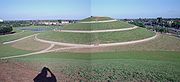
- Northala FieldsNorthala FieldsNorthala Fields is an award-winning country-style park located in Northolt, Greater London about 11 miles west of Marble Arch. It was opened in 2007 and consists of four artificial hills standing next to the A40 Western Avenue, as well as several fishing lakes and a large field area...
: a development of derelict land adjoining Rectory Fields in Northolt.
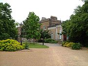
- Walpole ParkWalpole ParkWalpole Park is a municipal urban public open space run by Ealing Borough Council, and its main entrance is situated in Mattock Lane, Ealing, West London....
: Ealing's "premier park". Hosts a jazz and comedy festival in the summer, and also contains the Pitzhanger ManorPitzhanger ManorPitzhanger Manor House, in Ealing , was owned from 1800 to 1810 by the architect John Soane, who radically rebuilt it. Soane intended it as a country villa for entertaining and eventually for passing to his elder son. He demolished most of the existing building except the two-storey south wing...
museum. Contains a walled rose garden, semi-formal rest garden with wildlife pond, larger pond with fountain, open grass areas for games. The whole is enclosed either by railings and planted screening or surrounding houses. The park is closed at nights.
The Brent River Park is one of 11 parks throughout Greater London
Greater London
Greater London is the top-level administrative division of England covering London. It was created in 1965 and spans the City of London, including Middle Temple and Inner Temple, and the 32 London boroughs. This territory is coterminate with the London Government Office Region and the London...
chosen to receive money for redevelopment by a public vote in 2009. The park received £400,000 towards better footpaths, more lighting, refurbished public toilets and new play areas for children.
Allotments
Across the London Borough of Ealing there are 63 allotments sites. Most are council owned but a few are independent.The allotments in this part of London dramatically increased during WWII as part of the government effort to feed the nation. To encouraged the uptake of an allotment plots by people of whom had no access to a garden themselves, a campaign was waged under the slogan “Dig for Victory
Victory garden
Victory gardens, also called war gardens or food gardens for defense, were vegetable, fruit and herb gardens planted at private residences and public parks in United States, United Kingdom, Canada and Germany during World War I and World War II to reduce the pressure on the public food supply...
”. Towards the later end of the 20th century they became popular again amongst the growing ethic communities, as a source of some of their more familiar and traditional vegetables which were otherwise unobtainable in British shops. Some local organisations have now formally recognised some of the benefits that come from working on allotments and actively encourage their use.
Ealing Council has also signed up to the Unitary Development Plan
Unitary Development Plan
In United Kingdom planning law, a unitary development plan is an old-style development plan prepared by a metropolitan district and some unitary local authorities that contains policies equivalent to those in both a structure plan and a local plan...
which it is hoped will safeguard the existing allotments from building developers.
External links
- Ealing parks and open spaces Accessed 2010-02-17
- Northala Fields Accessed 2010-02-17
- Ealing Council (12 October 2000) Byelaws with respect to pleasure grounds, public walks and open spaces. Accessed 2010-02-18