

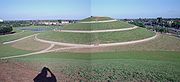
Northala Fields
Encyclopedia
Northolt
Northolt is a town in the London Borough of Ealing, England. The town has London Underground and Network Rail stations and is on the A40 road...
, Greater London
Greater London
Greater London is the top-level administrative division of England covering London. It was created in 1965 and spans the City of London, including Middle Temple and Inner Temple, and the 32 London boroughs. This territory is coterminate with the London Government Office Region and the London...
about 11 miles west of Marble Arch
Marble Arch
Marble Arch is a white Carrara marble monument that now stands on a large traffic island at the junction of Oxford Street, Park Lane, and Edgware Road, almost directly opposite Speakers' Corner in Hyde Park in London, England...
. It was opened in 2007 and consists of four artificial hills standing next to the A40 Western Avenue, as well as several fishing lakes and a large field area. The hills were constructed using rubble from the demolition of the original Wembley Stadium, which was closed in 2000 and demolished in 2003. The park was created as part of the Northolt and Greenford
Greenford
Greenford is a large suburb in the London Borough of Ealing in west London, UK. It was historically an ancient parish in the former county of Middlesex. The most prominent landmarks in the suburb are the A40, a major dual-carriageway; Horsenden Hill, above sea level; the small Parish Church of...
Country Park project, and backs onto the older Rectory Park.
The name "Northala" is how the old manor of Northall (Northolt) was recorded in the Domesday book
Domesday Book
Domesday Book , now held at The National Archives, Kew, Richmond upon Thames in South West London, is the record of the great survey of much of England and parts of Wales completed in 1086...
of 1086.
It is situated on what was the Royal Borough of Kensington Playing Fields after being leased to them in 1938. The section of the Ealing Road that formed the eastern perimeter was then renamed Kensington Road.
External links
- Ealing Council: Northala fields, http://www2.ealing.gov.uk/services/environment/parks_and_open_spaces/key_sites/northala.html Accessed 2011-09-04
- A 360° panoramic view from the highest of the four hills in Northala Fields.