
Dylife Gorge
Encyclopedia
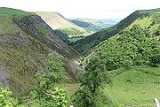
The Dylife Gorge, located near Dylife
, Powys
, Mid Wales
, was carved by the action (and aftermath) of the last Ice age
. It is headed by the Ffrwd Fawr Waterfall
.
Before the last Ice age, the River Twymyn
did not flow through the valley
. When the valley was filled by a glacier
, the ice ground out a U-shaped glaciated valley. When the glacier that filled the valley melted the Twymyn started to run down the wide channel left behind and the fast flowing river further eroded the valley, cutting the V-shaped gorge
as seen today.
The long-distance footpath Glyndŵr's Way
(Welsh: Llwybr Glyndŵr) passes nearby.
Dylife
Dylife is a former mining settlement in Powys, Mid Wales, located at the head of Afon Twymyn in the Cambrian Mountains, one mile west of the road between Llanidloes and Llanbrynmair . The nearby lead mines intermittently sustained mining communities from Roman times until the early 20th century...
, Powys
Powys
Powys is a local-government county and preserved county in Wales.-Geography:Powys covers the historic counties of Montgomeryshire and Radnorshire, most of Brecknockshire , and a small part of Denbighshire — an area of 5,179 km², making it the largest county in Wales by land area.It is...
, Mid Wales
Mid Wales
Mid Wales is the name given to the central region of Wales. The Mid Wales Regional Committee of the National Assembly for Wales covered the counties of Ceredigion and Powys and the area of Gwynedd that had previously been the district of Meirionydd. A similar definition is used by the BBC...
, was carved by the action (and aftermath) of the last Ice age
Ice age
An ice age or, more precisely, glacial age, is a generic geological period of long-term reduction in the temperature of the Earth's surface and atmosphere, resulting in the presence or expansion of continental ice sheets, polar ice sheets and alpine glaciers...
. It is headed by the Ffrwd Fawr Waterfall
Ffrwd Fawr Waterfall
- Location :The River Twymyn flows from the 130 feet high Ffrwd Fawr Waterfall at the head of the Pennant Valley at Dylife Gorge near Dylife.- External links :**...
.
Before the last Ice age, the River Twymyn
Afon Twymyn
The River Twymyn is a river in Powys, Mid Wales.From its source at the 40-metre high Ffrwd Fawr waterfall and head of the Pennant Valley near Dylife the river flows through Llanbrynmair before joining the River Dyfi upstream of Cemmaes Road.- See also :* Dylife Gorge...
did not flow through the valley
Valley
In geology, a valley or dale is a depression with predominant extent in one direction. A very deep river valley may be called a canyon or gorge.The terms U-shaped and V-shaped are descriptive terms of geography to characterize the form of valleys...
. When the valley was filled by a glacier
Glacier
A glacier is a large persistent body of ice that forms where the accumulation of snow exceeds its ablation over many years, often centuries. At least 0.1 km² in area and 50 m thick, but often much larger, a glacier slowly deforms and flows due to stresses induced by its weight...
, the ice ground out a U-shaped glaciated valley. When the glacier that filled the valley melted the Twymyn started to run down the wide channel left behind and the fast flowing river further eroded the valley, cutting the V-shaped gorge
Canyon
A canyon or gorge is a deep ravine between cliffs often carved from the landscape by a river. Rivers have a natural tendency to reach a baseline elevation, which is the same elevation as the body of water it will eventually drain into. This forms a canyon. Most canyons were formed by a process of...
as seen today.
The long-distance footpath Glyndŵr's Way
Glyndwr's Way
Glyndŵr's Way is a long distance footpath in mid Wales. It runs for in an extended loop through Powys between Knighton and Welshpool.- History :...
(Welsh: Llwybr Glyndŵr) passes nearby.