

Duncan Ridge Trail
Encyclopedia
Hiking
Hiking is an outdoor activity which consists of walking in natural environments, often in mountainous or other scenic terrain. People often hike on hiking trails. It is such a popular activity that there are numerous hiking organizations worldwide. The health benefits of different types of hiking...
trail
Trail
A trail is a path with a rough beaten or dirt/stone surface used for travel. Trails may be for use only by walkers and in some places are the main access route to remote settlements...
that has been designated as a National Recreation Trail
National Recreation Trail
National Recreation Trail is a designation given to existing trails that contribute to health, conservation, and recreation goals in the United States. Over 1,000 trails in all 50 U.S. states, available for public use and ranging from less than a mile to in length, have been designated as NRTs...
in Georgia
Georgia (U.S. state)
Georgia is a state located in the southeastern United States. It was established in 1732, the last of the original Thirteen Colonies. The state is named after King George II of Great Britain. Georgia was the fourth state to ratify the United States Constitution, on January 2, 1788...
. The trail is 35.5 miles (53.25 km.) long and traverses mountains, descends into valleys and features scenic viewpoints and waterfalls. It is located in the Chattahoochee National Forest and is maintained by the U.S. Forest Service in the Brasstown
Brasstown Ranger District
The Brasstown Ranger District is one of the five ranger districts of the Chattahoochee National Forest. The district includes land located in Lumpkin, Towns and Union counties, Georgia...
and Toccoa
Toccoa Ranger District
The Toccoa Ranger District is one of the five ranger districts of the Chattahoochee National Forest. The district is spread through portions of Dawson, Fannin, Gilmer, Lumpkin and Union Counties in Georgia...
Ranger Districts.
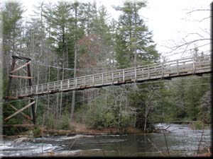
The Duncan Ridge Trail starts at an intersection with the Benton MacKaye Trail
Benton MacKaye Trail
The Benton MacKaye Trail or BMT is a footpath nearly in length in the Appalachian Mountains in the southeastern United States and is blazed by a white diamond, 5" across by 7" tall...
and the Appalachian Trail
Appalachian Trail
The Appalachian National Scenic Trail, generally known as the Appalachian Trail or simply the AT, is a marked hiking trail in the eastern United States extending between Springer Mountain in Georgia and Mount Katahdin in Maine. It is approximately long...
at Long Creek and crosses the Toccoa River on a 260 feet (79.2 m) swinging bridge. The eastern end of the trail combines with the Coosa Backcountry Trail and ultimately ends in the Blood Mountain Wilderness
Blood Mountain Wilderness
The Blood Mountain Wilderness was designated in 1991 and currently consists of . The Wilderness is located within the borders of the Chattahoochee National Forest in Lumpkin County and Union County, Georgia. The Wilderness is managed by the United States Forest Service and is part of the National...
, where it reconnects with the Appalachian Trail. Long Creek Falls
Long Creek Falls
Long Creek Falls is a waterfall located in Fannin County, Georgia. The falls are about 50 feet high and are fairly wide. The falls are located in Chattahoochee National Forest near Three Forks, and are accessible from the Appalachian Trail, the Benton MacKaye Trail, and the Duncan Ridge...
is a waterfall that is accessible from the Duncan Ridge Trail.
External links
- Duncan Ridge Trail entry in the National Recreation Trails Database
- http://www.fs.usda.gov/wps/portal/fsinternet/!ut/p/c5/04_SB8K8xLLM9MSSzPy8xBz9CP0os3gDfxMDT8MwRydLA1cj72BTJw8jAwgAykeaxcN4jhYG_h4eYX5hPgYwefy6w0H24dcPNgEHcDTQ9_PIz03VL8iNMMgycVQEAHcGOlk!/dl3/d3/L2dJQSEvUUt3QS9ZQnZ3LzZfME80MEkxVkFCOTBFMktTNUJIMjAwMDAwMDA!/?ss=110803&ttype=recarea&recid=64870&actid=50&navtype=BROWSEBYSUBJECT&position=BROWSEBYSUBJECT&navid=110340000000000&pnavid=110000000000000&cid=null&pname=Blue+Ridge+Ranger+District+-+Duncan+Ridge+TrailDuncan Ridge Trail website maintained by the Chattahoochee-Oconee National Forest]