

Dryden, Texas
Encyclopedia
Unincorporated area
In law, an unincorporated area is a region of land that is not a part of any municipality.To "incorporate" in this context means to form a municipal corporation, a city, town, or village with its own government. An unincorporated community is usually not subject to or taxed by a municipal government...
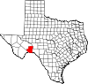
in south central Terrell County
Terrell County, Texas
Terrell County is a county located in the U.S. state of Texas. It is one of the nine counties that comprise the Trans-Pecos region of West Texas. In 2000, its population was 1,081. Its county seat is Sanderson. The county was named for Alexander W. Terrell, a Texas state senator...
, Texas
Texas
Texas is the second largest U.S. state by both area and population, and the largest state by area in the contiguous United States.The name, based on the Caddo word "Tejas" meaning "friends" or "allies", was applied by the Spanish to the Caddo themselves and to the region of their settlement in...
, United States
United States
The United States of America is a federal constitutional republic comprising fifty states and a federal district...
.
History
The community was founded in 1882 and named for Eugene E. Dryden, the chief engineer of the Galveston, Harrisburg and San Antonio Railway, which was building its tracks through Terrell County and established a section house at Dryden. Over the next several decades Dryden became a small center for ranching-based businesses. The headquarters for the Pecos Land and Cattle Company was established in Dryden in 1884. The company drilled a well that supplied the area with water.By 1912, a hotel, the Dryden Hotel, had been established, along with a combined schoolhouse, community center, and church. Dryden had a population of nearly 100 by 1929.
Two units of U.S. Army troops were stationed in Dryden during the 1913-1917 Mexican border unrest. During the Great Depression
Great Depression
The Great Depression was a severe worldwide economic depression in the decade preceding World War II. The timing of the Great Depression varied across nations, but in most countries it started in about 1929 and lasted until the late 1930s or early 1940s...
of the 1930s, the railway moved its crews and closed its depot at Dryden, and the area’s ranches were eventually broken up. Population began to dwindle to approximately fifty by 1970. Although a general store
General store
A general store, general merchandise store, or village shop is a rural or small town store that carries a general line of merchandise. It carries a broad selection of merchandise, sometimes in a small space, where people from the town and surrounding rural areas come to purchase all their general...
was operating in 1995, the population continued to decline to thirteen by 1988.
The post office dates from 1888. The United States Postal Service
United States Postal Service
The United States Postal Service is an independent agency of the United States government responsible for providing postal service in the United States...
currently maintains a post office in Dryden.
Geography
Dryden is located on U.S. Route 90 at the intersection with State Highway 349Texas State Highway 349
State Highway 349 or SH 349 is a 194.43 mile state highway in the western part of Texas.-History:The original formation of the highway in 1943 included only the section from Rankin to Midland, replacing a former route of . In 1947 and FM 306 were redesignated to form the part of SH 349 from...
, 100 miles (62 km) west of Del Rio
Del Rio, Texas
Del Rio is a border city in and the county seat of Val Verde County, Texas, United States.. Del Rio is connected with Ciudad Acuña via the Lake Amistad Dam International Crossing and Del Río-Ciudad Acuña International Bridge...
. Its coordinates are Lat: 30.04444, Lon: -102.11417.