
Drybridge
Encyclopedia
Drybridge is a village in North Ayrshire
, Scotland
. Drybridge is thus named because of the 'dry bridge' over the Kilmarnock and Troon Railway
, opened in 1812. The nearby 'wet bridge' is the Laigh Milton Viaduct
, the oldest surviving railway bridge in the world.
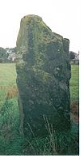
 The standing stone at Stane Field (NS 359 364), Drybridge, is the only one recorded for this local authority area. It stands close to the old railway station
. This standing stone is on level ground in a field of young crop at about 20 m OD. It has a maximum height of 2.6 m, and as stated, is roughly square with a girth of about 4.0 m and a maximum width of 1.3 m. A perforated stone axe head was found nearby. In this area are a cursus
, henge
, several sites of flint flake deposits and a twin concentric circle structure.
The railway which the "dry bridge" carried still exists and is still in use; Drybridge station has been converted into housing. Although the platforms survive, trains no longer stop at Drybridge station.
North Ayrshire
North Ayrshire is one of 32 council areas in Scotland with a population of roughly 136,000 people. It is located in the south-west region of Scotland, and borders the areas of Inverclyde to the north, Renfrewshire to the north-east and East Ayrshire and South Ayrshire to the East and South...
, Scotland
Scotland
Scotland is a country that is part of the United Kingdom. Occupying the northern third of the island of Great Britain, it shares a border with England to the south and is bounded by the North Sea to the east, the Atlantic Ocean to the north and west, and the North Channel and Irish Sea to the...
. Drybridge is thus named because of the 'dry bridge' over the Kilmarnock and Troon Railway
Kilmarnock and Troon Railway
The Kilmarnock and Troon Railway was the first railway line in Scotland authorised by Act of Parliament, in 1808; the engineer was William Jessop. It was the first railway in Scotland to use a steam locomotive; and it was the only one in Scotland for fourteen years...
, opened in 1812. The nearby 'wet bridge' is the Laigh Milton Viaduct
Laigh Milton Viaduct
Laigh Milton Viaduct is a railway viaduct near Laigh Milton mill at Gatehead in East Ayrshire, Scotland. It lies in the parishes of Kilmaurs and Dundonald, at map reference: NS 3834 3690. The viaduct was closed in 1846 when the railway line was realigned.- Laigh Milton viaduct :The stone viaduct...
, the oldest surviving railway bridge in the world.
Standing stone
Drybridge railway station
Drybridge railway station was a railway station serving the village of Drybridge, North Ayrshire, Scotland.-History:The station was opened on 6 July 1812 by the Kilmarnock and Troon Railway. The Glasgow, Paisley, Kilmarnock and Ayr Railway took over management of the station on 16 July 1846, while...
. This standing stone is on level ground in a field of young crop at about 20 m OD. It has a maximum height of 2.6 m, and as stated, is roughly square with a girth of about 4.0 m and a maximum width of 1.3 m. A perforated stone axe head was found nearby. In this area are a cursus
Cursus
thumb|right|250px|[[Stonehenge Cursus]], Wiltshirethumb|right|250px|[[Dorset Cursus]] terminal on Thickthorn Down, DorsetCursus was a name given by early British archaeologists such as William Stukeley to the large parallel lengths of banks with external ditches which they thought were early Roman...
, henge
Henge
There are three related types of Neolithic earthwork which are all sometimes loosely called henges. The essential characteristic of all three types is that they feature a ring bank and ditch but with the ditch inside the bank rather than outside...
, several sites of flint flake deposits and a twin concentric circle structure.
Facilities
Drybridge is a very basic village with few facilities.a village hall, post box, phone box and recycling facilities. There used to be a school/church here, which spent many years as a pallet makers workshop and store before recently being replaced by houses. The scrap-yard in the old station goods yard is now closed (2008).The railway which the "dry bridge" carried still exists and is still in use; Drybridge station has been converted into housing. Although the platforms survive, trains no longer stop at Drybridge station.