

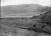
Dorrigo, New South Wales
Encyclopedia
Dorrigo is a small town located on the Waterfall Way
in northern New South Wales
, Australia
. It is approximately 580 kilometres north of the state capital, Sydney
via the Pacific Highway
, and 60 kilometres from the coastal city of Coffs Harbour
. The town is situated on the Dorrigo Plateau
near the New England Escarpment, which is part of the Great Dividing Range
. Dorrigo is 762 metres above sea level. At the 2006 census
, Dorrigo had a population of 967 people.
 Before European settlement the area that is now Dorrigo was inhabited by the Gumbaynggirr
. European settlement of the area followed on from the early timber cutters in the 1860s. The first official European in the district was Land Commissioner Oakes who sighted the mouth of the Bellinger River.
Dorrigo is derived from the Aboriginal word, dondorrigo, meaning "stringy-bark". For many decades it was believed that explorer and settler Major Edward Parke named the region after a Spanish General named Don Dorrigo with whom Peake fought in the Peninsula War.
By 1841, timber cutters had entered the Bellinger River searching for red cedar (Toona australis). They set up camps and moved from one stand of trees to the next.
Richard Craig
(an escaped convict from the Moreton Bay Penal Settlement), was the first European to discover the Plateau, following the traditional indigenous route to Armidale, New South Wales from the Grafton area. Using his skills as a horseman, Craig travelled along the western side of the Nymboida River. Craig's track became a road, now roughly following the same path as the present Grafton to Armidale Rd and travelling through the present day villages of Nymboida, Billy's Creek, Dundurrabin, Tyringham and Ebor (elevation 1300m). Timbergetters followed Craig through the sub tropical rainforest and many sawmills grew due to demand for timber, intitially the highly prized Australian Red Cedar (Toona australis).
Today, the main access road traversing the plateau from east to west is the Waterfall Way. It was not until the 1860s that permanent settlement occurred in the district. The dairy industry became a mainstay of the Dorrigo Plateau and today tourism is becoming more important. The nearby World Heritage listed Dorrigo National Park
and New England National Park
cater for persons interested in natural sights.
On 31 October 2005, sixty-eight dairy cows, all in full milk, died on a farm at Fernbrook on the Waterfall Way
near Dorrigo after being struck by lightning
. Three others were paralysed for several hours but they later made a full recovery. The cows were sheltering under a tree when it was struck by lightning and the electricity spread onto the surrounding soil killing the animals.
 Dorrigo is home to the Dorrigo Steam Railway and Museum
which houses the largest collection of preserved railway vehicles and memorabilia from the various Government and private railways of New South Wales. It is one of the most comprehensive railway collections in the world, with items in the collection ranging from 1855 to the present day. The museum is not yet open to the public however the larger items such as steam engines and carriages can be viewed from outside the property.
Note:
.
Waterfall Way
The Waterfall Way is a road and State Highway 78 in New South Wales, Australia. It runs east-west from the Pacific Highway to the New England Highway at Armidale. The route passes through some of New South Wales' most scenic countryside and has become well known as New South Wales best and...
in northern New South Wales
New South Wales
New South Wales is a state of :Australia, located in the east of the country. It is bordered by Queensland, Victoria and South Australia to the north, south and west respectively. To the east, the state is bordered by the Tasman Sea, which forms part of the Pacific Ocean. New South Wales...
, Australia
Australia
Australia , officially the Commonwealth of Australia, is a country in the Southern Hemisphere comprising the mainland of the Australian continent, the island of Tasmania, and numerous smaller islands in the Indian and Pacific Oceans. It is the world's sixth-largest country by total area...
. It is approximately 580 kilometres north of the state capital, Sydney
Sydney
Sydney is the most populous city in Australia and the state capital of New South Wales. Sydney is located on Australia's south-east coast of the Tasman Sea. As of June 2010, the greater metropolitan area had an approximate population of 4.6 million people...
via the Pacific Highway
Pacific Highway (Australia)
The Pacific Highway is a major transport route along part of the east coast of Australia and is part of Australia's national route 1.It is 960 km long and links Sydney, the capital of New South Wales, to Brisbane, the capital of Queensland, along the coast, via Gosford, Newcastle, Taree, Port...
, and 60 kilometres from the coastal city of Coffs Harbour
Coffs Harbour, New South Wales
-History:By the early 1900s, the Coffs Harbour area had become an important timber production centre. Before the opening of the North Coast Railway Line, the only way to transport large items of heavy but low value, such as timber, was by coastal shipping. This meant sawmillers on the North Coast...
. The town is situated on the Dorrigo Plateau
Dorrigo Plateau
Dorrigo Plateau is a plateau in northern New South Wales, which forms part of the Great Dividing Range. The plateau is sometimes referred to as the Dorrigo & Guy Fawkes Plateau....
near the New England Escarpment, which is part of the Great Dividing Range
Great Dividing Range
The Great Dividing Range, or the Eastern Highlands, is Australia's most substantial mountain range and the third longest in the world. The range stretches more than 3,500 km from Dauan Island off the northeastern tip of Queensland, running the entire length of the eastern coastline through...
. Dorrigo is 762 metres above sea level. At the 2006 census
Census in Australia
The Australian census is administered once every five years by the Australian Bureau of Statistics. The most recent census was conducted on 9 August 2011; the next will be conducted in 2016. Prior to the introduction of regular censuses in 1961, they had also been run in 1901, 1911, 1921, 1933,...
, Dorrigo had a population of 967 people.
History
Gumbaynggirr
Gumbaynggir are an Australian Aboriginal group of the Coffs Harbour, New South Wales area. The Gumbaynggirr lands cover an area of the Mid North Coast from the Nambucca River to as far north as the Clarence River , west to Armidale and eastward to the Pacific coast, making the Gumbaynggirr tribe...
. European settlement of the area followed on from the early timber cutters in the 1860s. The first official European in the district was Land Commissioner Oakes who sighted the mouth of the Bellinger River.
Dorrigo is derived from the Aboriginal word, dondorrigo, meaning "stringy-bark". For many decades it was believed that explorer and settler Major Edward Parke named the region after a Spanish General named Don Dorrigo with whom Peake fought in the Peninsula War.
By 1841, timber cutters had entered the Bellinger River searching for red cedar (Toona australis). They set up camps and moved from one stand of trees to the next.
Richard Craig
Richard Craig (adventurer)
Richard Craig was a free settler in the colony of New South Wales, a convicted criminal, an escaped convict, and a pardoned convict who worked as a stockman and drover.-Early life:...
(an escaped convict from the Moreton Bay Penal Settlement), was the first European to discover the Plateau, following the traditional indigenous route to Armidale, New South Wales from the Grafton area. Using his skills as a horseman, Craig travelled along the western side of the Nymboida River. Craig's track became a road, now roughly following the same path as the present Grafton to Armidale Rd and travelling through the present day villages of Nymboida, Billy's Creek, Dundurrabin, Tyringham and Ebor (elevation 1300m). Timbergetters followed Craig through the sub tropical rainforest and many sawmills grew due to demand for timber, intitially the highly prized Australian Red Cedar (Toona australis).
Today, the main access road traversing the plateau from east to west is the Waterfall Way. It was not until the 1860s that permanent settlement occurred in the district. The dairy industry became a mainstay of the Dorrigo Plateau and today tourism is becoming more important. The nearby World Heritage listed Dorrigo National Park
Dorrigo National Park
Dorrigo National Park is a national park in New South Wales , 580 km north of Sydney on Dome Road off the Waterfall Way, 5 km east of the town of Dorrigo....
and New England National Park
New England National Park
New England National Park is situated on the Northern Tablelands in the New England region of New South Wales, Australia, 560 km north of Sydney. It is about 10 km south of Waterfall Way, just 85 km east of Armidale and 65 km west of Coffs Harbour...
cater for persons interested in natural sights.
On 31 October 2005, sixty-eight dairy cows, all in full milk, died on a farm at Fernbrook on the Waterfall Way
Waterfall Way
The Waterfall Way is a road and State Highway 78 in New South Wales, Australia. It runs east-west from the Pacific Highway to the New England Highway at Armidale. The route passes through some of New South Wales' most scenic countryside and has become well known as New South Wales best and...
near Dorrigo after being struck by lightning
Lightning
Lightning is an atmospheric electrostatic discharge accompanied by thunder, which typically occurs during thunderstorms, and sometimes during volcanic eruptions or dust storms...
. Three others were paralysed for several hours but they later made a full recovery. The cows were sheltering under a tree when it was struck by lightning and the electricity spread onto the surrounding soil killing the animals.
Dorrigo Steam Railway and Museum
The Dorrigo Steam Railway and Museum in Dorrigo, New South Wales, Australia is a large, privately owned collection of preserved railway vehicles and equipment from the railways of New South Wales, covering both Government and private railways...
which houses the largest collection of preserved railway vehicles and memorabilia from the various Government and private railways of New South Wales. It is one of the most comprehensive railway collections in the world, with items in the collection ranging from 1855 to the present day. The museum is not yet open to the public however the larger items such as steam engines and carriages can be viewed from outside the property.
Dangar Falls
Dangar Falls are located about 1.2 km north of Dorrigo, on the Bielsdown River. The falls are small but picturesque, and are a popular photographic subject. For a short time after rain they are quite spectacular. There is an attractive picnic spot which offers excellent views. It is possible to climb down the banks and walk along the river below the water falls.Note:
- These falls are often confused with Dangars Falls, near ArmidaleArmidale, New South WalesArmidale is a city in the Northern Tablelands, New South Wales, Australia. Armidale Dumaresq Shire had a population of 19,485 people according to the 2006 census. It is the administrative centre for the Northern Tablelands region...
, about 125 km to the west, along the Waterfall WayWaterfall WayThe Waterfall Way is a road and State Highway 78 in New South Wales, Australia. It runs east-west from the Pacific Highway to the New England Highway at Armidale. The route passes through some of New South Wales' most scenic countryside and has become well known as New South Wales best and...
. - For more information about Dangars Falls see the articles on DangarsleighDangarsleigh, New South WalesDangarsleigh is a minor trigonometrical station, parish and rural locality about 11 km south east of Armidale, New South Wales. The locality is at an altitude of about 1,020 metres on the Northern Tablelands in the New England region of New South Wales, Australia. The name Dangarsleigh...
and on the Oxley Wild Rivers National ParkOxley Wild Rivers National ParkOxley Wild Rivers National Park is in New South Wales, Australia, 445 kilometres north of Sydney and is named in memory of the Australian explorer John Oxley, who passed through the area in 1818...
.
Media
A local newspaper, the Don Dorrigo Gazette, was first published in 1910. It is believed to be the last newspaper in Australia printed using hot metal typesettingHot metal typesetting
In printing and typography, hot metal typesetting refers to 19th-century technologies for typesetting text in letterpress printing. This method injects molten type metal into a mold that has the shape of one or more glyphs...
.