Dolores Park
Encyclopedia
Mission Dolores Park is a San Francisco, California
, city park located in the neighborhood of Mission Dolores, at the western edge of the Mission District, which lies to the east of the park. To the west of the park is a hillside referred to as "Dolores Heights" or considered a part of the Castro
neighborhood. Dolores Park is two blocks tall by one block wide, based on the configuration of north-south and east-west blocks in that part of San Francisco. It is bounded by 18th Street on the north, 20th Street to the south, Dolores Street to the east and Church Street to the west. The northern end of Dolores Park is located directly across the street from Mission High School.
Dolores park offers several features: several tennis courts and a basketball court, a soccer field, a children's playground, and a dog play area. The southern half of the park is also notable for its views of the Mission district, downtown, the San Francisco Bay
and the East Bay
. Also notable is the routing of the Muni Metro
J-Church
streetcar line through the park.
The park lies east of Twin Peaks in the warm and sunny microclimate
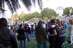
of the Mission neighborhood. The park is popular among San Franciscans looking for outdoor relaxation and recreation.

 Dolores Park is named after Mission Dolores, established by Spanish missionaries in 1776. Native Americans
of the Chutchui village of the Yelamu
tribe inhabited the area prehistorically before Spanish missionaries arrived.
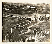
The park site consists of two plots, Mission Blocks #86 and #87, owned by Congregation Sherith Israel and Congregation Emanu-El and was used as a Jewish cemetery which became inactive in 1894. The cemetery was moved to San Mateo County when San Francisco land became too valuable for the dead and burial within the city limits was prohibited. The graves were moved to Colma
(via Southern Pacific
railroad), where they still rest today at Hills of Eternity and Home of Peace Cemeteries.
In 1905, the City of San Francisco bought the land of Dolores Park for $291,350 (equivalent to about $4 million in 2004). In 1906-07, the park served as a refugee camp for more than 1600 families made homeless by the 1906 San Francisco Earthquake
and fire. Camp life after the earthquake ended in the summer of 1908. Some people kept their temporary shacks as houses and a few still survive today scattered across western San Francisco. In 1917, the J-Church streetcar line, which runs along one side of the park, began service.
 Dolores Park has six tennis
courts and one basketball
court; two soccer fields, a playground
, and a clubhouse with public restrooms. Dolores Park has been the neighborhood center for cultural, political and sports activities since the 1960s. It has hosted political rallies, festivals, Aztec
ceremonial dances, Cinco de Mayo
celebrations, and San Francisco Mime Troupe
performances.
In 2010, it was announced that the park is to be closed throughout 2011 as part of massive renovations and a construction of a new playground.
San Francisco, California
San Francisco , officially the City and County of San Francisco, is the financial, cultural, and transportation center of the San Francisco Bay Area, a region of 7.15 million people which includes San Jose and Oakland...
, city park located in the neighborhood of Mission Dolores, at the western edge of the Mission District, which lies to the east of the park. To the west of the park is a hillside referred to as "Dolores Heights" or considered a part of the Castro
The Castro, San Francisco, California
The Castro District, commonly referenced as The Castro, is a neighborhood in Eureka Valley in San Francisco, California. The Castro is one of America's first and best-known gay neighborhoods, and it is currently its largest...
neighborhood. Dolores Park is two blocks tall by one block wide, based on the configuration of north-south and east-west blocks in that part of San Francisco. It is bounded by 18th Street on the north, 20th Street to the south, Dolores Street to the east and Church Street to the west. The northern end of Dolores Park is located directly across the street from Mission High School.
Dolores park offers several features: several tennis courts and a basketball court, a soccer field, a children's playground, and a dog play area. The southern half of the park is also notable for its views of the Mission district, downtown, the San Francisco Bay
San Francisco Bay
San Francisco Bay is a shallow, productive estuary through which water draining from approximately forty percent of California, flowing in the Sacramento and San Joaquin rivers from the Sierra Nevada mountains, enters the Pacific Ocean...
and the East Bay
East Bay (San Francisco Bay Area)
The East Bay is a commonly used, informal term for the lands on the eastern side of the San Francisco Bay, in the San Francisco Bay Area, in California, United States...
. Also notable is the routing of the Muni Metro
Muni Metro
Muni Metro is a light rail system serving San Francisco, California, operated by the San Francisco Municipal Railway , a division of the San Francisco Municipal Transportation Agency...
J-Church
J Church
The J Church is a Muni Metro railway line in San Francisco, California mainly serving the Noe Valley and Balboa Park neighborhoods, connecting them to downtown. It began as one of San Francisco's streetcar lines in 1917, and was converted to modern light rail operation with the creation of the Muni...
streetcar line through the park.
The park lies east of Twin Peaks in the warm and sunny microclimate
Microclimate
A microclimate is a local atmospheric zone where the climate differs from the surrounding area. The term may refer to areas as small as a few square feet or as large as many square miles...
of the Mission neighborhood. The park is popular among San Franciscans looking for outdoor relaxation and recreation.
History


Native Americans in the United States
Native Americans in the United States are the indigenous peoples in North America within the boundaries of the present-day continental United States, parts of Alaska, and the island state of Hawaii. They are composed of numerous, distinct tribes, states, and ethnic groups, many of which survive as...
of the Chutchui village of the Yelamu
Yelamu
The Yelamu were a Native American tribe of Ohlone people from the San Francisco Bay Area in Northern California.-History:The Yelamu lived on the northern tip of the San Francisco Peninsula in the region comprising the City and County of San Francisco before the arrival of Spanish missionaries in 1769...
tribe inhabited the area prehistorically before Spanish missionaries arrived.
The park site consists of two plots, Mission Blocks #86 and #87, owned by Congregation Sherith Israel and Congregation Emanu-El and was used as a Jewish cemetery which became inactive in 1894. The cemetery was moved to San Mateo County when San Francisco land became too valuable for the dead and burial within the city limits was prohibited. The graves were moved to Colma
Colma, California
Colma is a small incorporated town in San Mateo County, California, at the northern end of the San Francisco Peninsula in the San Francisco Bay Area. The population was 1,792 at the 2010 census. The town was founded as a necropolis in 1924....
(via Southern Pacific
Southern Pacific Railroad
The Southern Pacific Transportation Company , earlier Southern Pacific Railroad and Southern Pacific Company, and usually simply called the Southern Pacific or Espee, was an American railroad....
railroad), where they still rest today at Hills of Eternity and Home of Peace Cemeteries.
In 1905, the City of San Francisco bought the land of Dolores Park for $291,350 (equivalent to about $4 million in 2004). In 1906-07, the park served as a refugee camp for more than 1600 families made homeless by the 1906 San Francisco Earthquake
1906 San Francisco earthquake
The San Francisco earthquake of 1906 was a major earthquake that struck San Francisco, California, and the coast of Northern California at 5:12 a.m. on Wednesday, April 18, 1906. The most widely accepted estimate for the magnitude of the earthquake is a moment magnitude of 7.9; however, other...
and fire. Camp life after the earthquake ended in the summer of 1908. Some people kept their temporary shacks as houses and a few still survive today scattered across western San Francisco. In 1917, the J-Church streetcar line, which runs along one side of the park, began service.
Facilities

Tennis
Tennis is a sport usually played between two players or between two teams of two players each . Each player uses a racket that is strung to strike a hollow rubber ball covered with felt over a net into the opponent's court. Tennis is an Olympic sport and is played at all levels of society at all...
courts and one basketball
Basketball
Basketball is a team sport in which two teams of five players try to score points by throwing or "shooting" a ball through the top of a basketball hoop while following a set of rules...
court; two soccer fields, a playground
Playground
A playground or play area is a place with a specific design for children be able to play there. It may be indoors but is typically outdoors...
, and a clubhouse with public restrooms. Dolores Park has been the neighborhood center for cultural, political and sports activities since the 1960s. It has hosted political rallies, festivals, Aztec
Aztec
The Aztec people were certain ethnic groups of central Mexico, particularly those groups who spoke the Nahuatl language and who dominated large parts of Mesoamerica in the 14th, 15th and 16th centuries, a period referred to as the late post-classic period in Mesoamerican chronology.Aztec is the...
ceremonial dances, Cinco de Mayo
Cinco de Mayo
Cinco de Mayo is a holiday held on May 5. It is celebrated nationwide in the United States and regionally in Mexico, primarily in the state of Puebla, where the holiday is called El Dia de la Batalla de Puebla...
celebrations, and San Francisco Mime Troupe
San Francisco Mime Troupe
The San Francisco Mime Troupe is a theatre of political satire which performs free shows in various parks in the San Francisco Bay Area and around California. The Troupe does not, however, perform silent mime, but each year creates an original musical comedy that combines aspects of Commedia...
performances.
In 2010, it was announced that the park is to be closed throughout 2011 as part of massive renovations and a construction of a new playground.
Geography and territories
Dolores Park is a community of territories and cultures that are designated by location within the park. The park is divided into Northern and Southern hemispheres by a walkway that stems from 19th St. running East to West.See also
- San Francisco City ParksParks in San Francisco, California-Federal:National Park Service*Golden Gate National Recreation Area , including**Alcatraz**China Beach**Fort Funston**Fort Mason**Fort Miley **Lands End**Ocean Beach**The Presidio, including***Baker Beach***Crissy Field***Fort Point...
External links
- Dolores Park Historic Resource Evaluation
- Mission Dolores Neighborhood Association
- Dolores Heights Improvement Club
- Dolores Park View
- "History of Dolores Park," a photo slideshow from The Bay Citizen, a nonprofit Bay Area news site

