

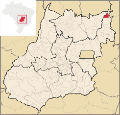
Divinópolis de Goiás
Encyclopedia
| Divinópolis | |
|---|---|
| State | Goiás Goiás Goiás is a state of Brazil, located in the central part of the country. The name Goiás comes from the name of an indigenous community... |
| Geographical Coordinates: | 13°17′36"S 46°23′46"W |
| Area: | 831.134 km² |
| Population: | 5,344(IBGE 2007) |
| Elevation: | 620m |
| Postcode (CEP): | 73865-000 |
| IBGE statistical microregion: | 018 Vão do Paranã |
| Became a city: | 1989 |
| Mayor: | Valdiram Pereira dos Santos |
| Distance to Goiânia Goiânia -Climate:The city has a tropical wet and dry climate with an average temperature of . There's a wet season, from October to April, and a dry one, from May to September. Annual rainfall is around 1,520 mm.... : |
642 km. |
| Website: | n/a |
Town
A town is a human settlement larger than a village but smaller than a city. The size a settlement must be in order to be called a "town" varies considerably in different parts of the world, so that, for example, many American "small towns" seem to British people to be no more than villages, while...
and municipality
Municipality
A municipality is essentially an urban administrative division having corporate status and usually powers of self-government. It can also be used to mean the governing body of a municipality. A municipality is a general-purpose administrative subdivision, as opposed to a special-purpose district...
in northeastern Goiás
Goiás
Goiás is a state of Brazil, located in the central part of the country. The name Goiás comes from the name of an indigenous community...
state, Brazil
Brazil
Brazil , officially the Federative Republic of Brazil , is the largest country in South America. It is the world's fifth largest country, both by geographical area and by population with over 192 million people...
.
Geography
Divinópolis de Goiás is part of the Vão do Paranã statistical micro-region, which consists of 12 municipalities with 88,913 inhabitants in a total area of 17,452.90 km². Divinópolis is one of the farthest towns from the state capital and one of the most isolated and poorest. The distance to GoiâniaGoiânia
-Climate:The city has a tropical wet and dry climate with an average temperature of . There's a wet season, from October to April, and a dry one, from May to September. Annual rainfall is around 1,520 mm....
is 642 km. Highway connections are made by BR-153 / Anápolis
Anápolis
Anápolis is the third largest city in the State of Goiás in Brazil. It lies in the center of a rich agricultural region and has become a leader in food processing and pharmaceutical plants.-Location and population:...
/ Alexânia
Alexânia
Alexânia is a small town and municipality in central Goiás state, Brazil. Alexânia is known for its alleged extraterrestrial sightings in the late sixties and early seventies. The Areias River passes through the municipality.-Location:...
/ BR-060 / Planaltina
Planaltina
Planaltina is one of the administrative districts of the Federal District of Brazil, with an area of 1,534 kmª and a population of 147,114 in 2000, of whom 134,663 were classified as urban and 12,451 as rural...
/ GO-430 / GO-118 / BR-010 / São João da Aliança / Alto Paraíso de Goiás
Alto Paraíso de Goiás
Alto Paraíso de Goiás is a small town and a municipality in northeastern Goiás state, Brazil. It has become known for its ecological and New Age tourism.-Location:...
/ Teresina de Goiás
Teresina de Goiás
Teresina de Goiás is a small town and municipality in northern Goiás state, Brazil.-Location:It is part of the region of the statistical micro-region of Chapada dos Veadeiros and is located north of the Federal District and Brasília. It is 67 km north of Alto Paraíso de Goiás. The nearest...
/ Monte Alegre de Goiás
Monte Alegre de Goiás
Monte Alegre de Goiás is a small town and municipality in northeastern Goiás state, Brazil.-Location:Monte Alegre is located in the statistical micro-region of Chapada dos Veadeiros and is 31 kilometers south of the border with Tocantins. G0-118 connects it with Teresina de Goiás and Campos Belos...
/ GO-447 / Vazante
Vazante
Vazante is a municipality in the north of the Brazilian state of Minas Gerais. Its population in 2007 was 19,300 inhabitants in a total area of 1,903 km². It is a large producer of cattle and there is mining of zinc.-Location:...
. (64 km. unpaved road).
It is part of the diocese of Formosa
Formosa, Goiás
Formosa is a city and municipality located in the state of Goiás, Brazil, approximately 80 kilometers east of Brasília. The population was 90,247 in a total area of 5,806.89 km² . Formosa is known for its waterfalls and natural beauty...
, a diocese that has an area of 47,604.7 km² and a population of 285,427 inhabitants. A curiosity is that there are only 23 priests and 45 nuns for this enormous area.
It is bordered in the north by the state of Tocantins
Tocantins (state)
Tocantins is one of the states of Brazil. . The state was formed in 1988 out of the northern part of Goiás, and construction began on the capital, Palmas, in 1989, in contrast to most of the other cities in the state which date back to the Portuguese colonial period...
and in the east and south by the municipality of São Domingos
São Domingos, Goiás
São Domingos is a small town and municipality in northeastern Goiás state, Brazil. It is a large producer of beef cattle but is one of the poorest towns in the state.-Location:...
.
- Villages (povoados): Monte Santo
- Hamlets (Aglomerados): Mangabeira, Porteiras and Vazante
Demographics
- Population density: 6.43 inhab/km²
- Total population in 1980: 4,244
- Total population in 2007: 5,344
- Urban population: 3,116
- Rural population: 2,228
- Population growth rate: 0.58%
The economy
The most important economic activities are cattle raising and modest production of rice, bananas, sugarcane, and corn. In 2007 there were 51 commercial units. There were no banks.- Motor vehicles (automobiles and pickup trucks): 117 (2007)
- Number of inhabitants per motor vehicle: 45.6
Agricultural data 2006
- Farms: 314
- Total area: 81,731 ha.
- Area of permanent crops: 246 ha.
- Area of perennial crops: 1,753 ha.
- Area of pasture: 45,641 ha.
- Area of woodland and forests: 30,202 ha.
- People dependent on agriculture: 1,100
- Cattle herd: 58,277
Health and education
- Literacy rate: 74.8%
- Infant mortality rate: 23.93 in 1,000 live births
- Hospitals: 01 (2007
- Hospital beds: 26
- Schools: 9 with 1,895 students
Divinópolis de Goiás was ranked 224 out of 242 municipalities in the state of Goiás on the United Nations Human Development Index
Human Development Index
The Human Development Index is a composite statistic used to rank countries by level of "human development" and separate "very high human development", "high human development", "medium human development", and "low human development" countries...
with a score of 0.675 (data from 2000). Nationally it was ranked 3,375 out of 5,507 municipalities. Data are from 2000.
History
The settlement of the region began in 1880 with the Galheiros Ranch, owned by Inácia Ferreira Lima, who incentivated the arrival of settlers from the state of BahiaBahia
Bahia is one of the 26 states of Brazil, and is located in the northeastern part of the country on the Atlantic coast. It is the fourth most populous Brazilian state after São Paulo, Minas Gerais and Rio de Janeiro, and the fifth-largest in size...
. Lands were donated to build a chapel to São João Bautista (Saint John the Baptist) and soon houses began to appear. In 1890 the village (povoado) was raised to the status of district belonging to São Domingos
São Domingos, Goiás
São Domingos is a small town and municipality in northeastern Goiás state, Brazil. It is a large producer of beef cattle but is one of the poorest towns in the state.-Location:...
with the name of Galheiros, taking the name of the ranch with the same name. In 1958 it separated and became a municipality with the same name. This was changed to Cirinópolis in 1964 in honor of Luis Pereira Cirino, who had fought hard to make it a municipality. Later, in 1989 the name was changed to Divinópolis de Goiás.
Notes