

Dent Blanche
Encyclopedia
The Dent Blanche is a mountain
in the Pennine
Alps
, lying in the canton of Valais
in Switzerland
. With its 4356 metres (14,291 ft) high summit, it is one of the highest peaks in the Alps
.
which does not overlook the Val d'Hérens
. The nearby north face of the Dent d'Hérens is glaciated while the Dent Blanche holds much less snow, it was even called Dent Noire (Black Tooth) on the Woerl Atlas of 1842. In fact on older maps, in the area where lie both summits, only the name Weisszahnhorn (from German: White Tooth Peak) was indicated, the French name (Dent Blanche) appearing in 1820 only. Because cartographers usually made their observations far away from the mountainous remote areas and also because the Dent d'Hérens is sometime hidden behind the Dent Blanche thus less visible, the latter received the name. The inabitants of the lower Val d'Hérens called the actual Dent d'Hérens, Dent Blanche, but the ones of the upper Val d'Hérens called the mountain, Dent de Rong or Dent d'Erins, contributing to the general confusion. The actual names are official since the completion of the Dufour map in 1862.
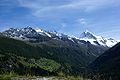 The summit of Dent Blanche is an important geographic place as it is the converging point of three ridges. The three valleys separated by them are the Val d'Hérens
, Val d'Anniviers
and Mattertal
. The respective villages of Evolène
, Zinal
and Zermatt
lie approximatively at the same distance of the mountain.
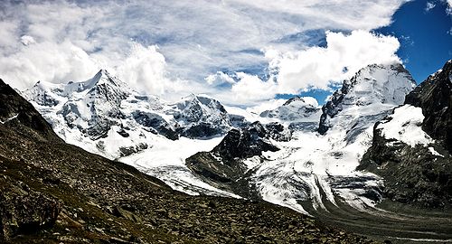
The Dent Blanche has four steep faces rising over four glaciers: The north-east face (also called north face) rises above the Grand Cornier Glacier (part of the Zinal Glacier
), the south-east face rises above the Schönbiel Glacier (part of the Zmutt Glacier
), the south-west face rises above the Manzettes Glacier (part of the Ferpècle Glacier
) and, finally, the north-west face of Dent Blanche rises above the homonym glacier.
The four ridges encompass almost exactly the four cardinal directions. The west ridge is named Arête de Ferpècle and the east ridge is named Arête des Quatre Ânes. The Col de la Dent Blanche (3,531 m) lies at the foot of the northern ridge, the Bivouac de la Dent Blanche is located there. The Dent Blanche Hut lies at the foot of the southern ridge which is used as the normal route.
The region around Dent Blanche consists of many 4000 metres peaks. The Ober Gabelhorn
(west), Dent d'Hérens
and Matterhorn
(south) are the closest high summits.
 The first ascent was made via the south ridge (Wandfluegrat), which is the less difficult route to the summit and the actual normal route. On 12 July 1862, T. S. Kennedy, after an attempt on the east face of the unconquered Matterhorn
, almost reached the summit with the guides Peter Taugwalder and his son. But after a minor accident, Peter Taugwalder refused to go any higher. Kennedy would finally reach the summit only a few days later, on July 18, 1862 with W. Wigram, J. Croz and J. Konig, despite adverse weather conditions.
A route on the west ridge was opened on 11 August 1882 by John Stafford Anderson and G. P. Baker, with guides Alois Pollinger and Ulrich Almer. They started from the Mountet Hut and arrived at the summit after a difficult 12 hours climbing on a dangerous ridge overlooking the north face. As Almer said on the summit: "We are four asses", the ridge was then named Arête des Quatre Ânes or Viereselsgrat (Ridge of the Four Asses).
The north ridge was explored in 1899. On 28 August O. G. Jones, F. W. Hill with guides E. Furrer, C. Zurbriggen and J. Vuignier headed to the summit but they fell and only Hill survived. He reached alone the summit and a storm forced him to make a bivouac. He could report the news of the fatal accident in Zermatt only two days later.
The first ascent of the north face is attributed to K. Schneider and F. Singer on 26 and 27 August 1932. They climbed from the left part at the base of the face to the summit. Only on 12 July 1966, M. and Y. Vaucher made a direct ascent on the north face.
The first winter ascent by the north ridge was completed by P. Crettaz and J. Gaudin on March 2, 1963.
A solo winter ascent on the north face was made for the first time in 1968 by C. Bournissen.
Mountain
Image:Himalaya_annotated.jpg|thumb|right|The Himalayan mountain range with Mount Everestrect 58 14 160 49 Chomo Lonzorect 200 28 335 52 Makalurect 378 24 566 45 Mount Everestrect 188 581 920 656 Tibetan Plateaurect 250 406 340 427 Rong River...
in the Pennine
Pennine Alps
The Pennine Alps are a mountain range in the western part of the Alps. They are located in Switzerland and Italy...
Alps
Swiss Alps
The Swiss Alps are the portion of the Alps mountain range that lies within Switzerland. Because of their central position within the entire Alpine range, they are also known as the Central Alps....
, lying in the canton of Valais
Valais
The Valais is one of the 26 cantons of Switzerland in the southwestern part of the country, around the valley of the Rhône from its headwaters to Lake Geneva, separating the Pennine Alps from the Bernese Alps. The canton is one of the drier parts of Switzerland in its central Rhône valley...
in Switzerland
Switzerland
Switzerland name of one of the Swiss cantons. ; ; ; or ), in its full name the Swiss Confederation , is a federal republic consisting of 26 cantons, with Bern as the seat of the federal authorities. The country is situated in Western Europe,Or Central Europe depending on the definition....
. With its 4356 metres (14,291 ft) high summit, it is one of the highest peaks in the Alps
Alps
The Alps is one of the great mountain range systems of Europe, stretching from Austria and Slovenia in the east through Italy, Switzerland, Liechtenstein and Germany to France in the west....
.
Naming
The original name was probably Dent d'Hérens, the actual name of the nearby Dent d'HérensDent d'Hérens
The Dent d'Hérens is a mountain in the Pennine Alps, lying on the border between Italy and Switzerland. The mountain lies a few kilometres west of the Matterhorn.The Aosta hut is used for the normal route.-Naming:...
which does not overlook the Val d'Hérens
Val d'Hérens
Val d'Hérens is an alpine valley in the Valais canton of Switzerland. It was formed by the Hérens glacier, which retreated at the end of the last ice age....
. The nearby north face of the Dent d'Hérens is glaciated while the Dent Blanche holds much less snow, it was even called Dent Noire (Black Tooth) on the Woerl Atlas of 1842. In fact on older maps, in the area where lie both summits, only the name Weisszahnhorn (from German: White Tooth Peak) was indicated, the French name (Dent Blanche) appearing in 1820 only. Because cartographers usually made their observations far away from the mountainous remote areas and also because the Dent d'Hérens is sometime hidden behind the Dent Blanche thus less visible, the latter received the name. The inabitants of the lower Val d'Hérens called the actual Dent d'Hérens, Dent Blanche, but the ones of the upper Val d'Hérens called the mountain, Dent de Rong or Dent d'Erins, contributing to the general confusion. The actual names are official since the completion of the Dufour map in 1862.
Geography
Val d'Hérens
Val d'Hérens is an alpine valley in the Valais canton of Switzerland. It was formed by the Hérens glacier, which retreated at the end of the last ice age....
, Val d'Anniviers
Val d'Anniviers
The val d'Anniviers is a Swiss alpine valley, situated in the district of Sierre in Valais, which extends south of the Rhône Valley. The valley was home to six municipalities: Ayer, Chandolin, Grimentz, Saint-Jean, Saint-Luc, Vissoie, Vercorin and Zinal. The citizens of those municipalities agreed...
and Mattertal
Mattertal
The Matter Valley is located in southwestern Switzerland, south of the Rhone valley in the canton of Valais. The village of Zermatt is the most important settlement of the valley, which is surrounded by many four-thousanders, including the Matterhorn.-Geography:Located in the Pennine Alps, the...
. The respective villages of Evolène
Evolène
Evolène is a municipality in the district of Hérens in the canton of Valais in Switzerland.-History:Evolène is first mentioned in 1250 as Ewelina. In 1444 it was mentioned as in loco de Evolena.- Avalanches of the 21st of February, 1999 :...
, Zinal
Zinal
Zinal is a village located in the municipality of Anniviers in the canton of Valais in Switzerland. It lies at an altitude of 1,675 metres in the Swiss Alps in the Val d'Anniviers, a valley running from the Zinal Glacier, north of Dent Blanche to the village of Ayer...
and Zermatt
Zermatt
Zermatt is a municipality in the district of Visp in the German-speaking section of the canton of Valais in Switzerland. It has a population of about 5,800 inhabitants....
lie approximatively at the same distance of the mountain.
The Dent Blanche has four steep faces rising over four glaciers: The north-east face (also called north face) rises above the Grand Cornier Glacier (part of the Zinal Glacier
Zinal Glacier
The Zinal Glacier is a long glacier situated in the Pennine Alps in the canton of Valais in Switzerland. In 1973 it had an area of . The glacier gives birth to the Navissence River, which runs through a cave.-External links:*...
), the south-east face rises above the Schönbiel Glacier (part of the Zmutt Glacier
Zmutt Glacier
The Zmutt Glacier is a long glacier situated in the Pennine Alps in the canton of Valais in Switzerland. In 1973 it had an area of .-External links:*...
), the south-west face rises above the Manzettes Glacier (part of the Ferpècle Glacier
Ferpècle Glacier
The Ferpècle Glacier is a long glacier situated in the Pennine Alps in the canton of Valais in Switzerland. In 1973 it had an area of .-External links:*...
) and, finally, the north-west face of Dent Blanche rises above the homonym glacier.
The four ridges encompass almost exactly the four cardinal directions. The west ridge is named Arête de Ferpècle and the east ridge is named Arête des Quatre Ânes. The Col de la Dent Blanche (3,531 m) lies at the foot of the northern ridge, the Bivouac de la Dent Blanche is located there. The Dent Blanche Hut lies at the foot of the southern ridge which is used as the normal route.
The region around Dent Blanche consists of many 4000 metres peaks. The Ober Gabelhorn
Ober Gabelhorn
The Ober Gabelhorn is a mountain in the Pennine Alps in Switzerland, located between Zermatt and Zinal.-Geography:The Ober Gabelhorn lies in the Swiss canton of Valais at the southern end of the Zinal valley . It rises, together with the Dent Blanche and the Zinalrothorn , above the Zinal Glacier...
(west), Dent d'Hérens
Dent d'Hérens
The Dent d'Hérens is a mountain in the Pennine Alps, lying on the border between Italy and Switzerland. The mountain lies a few kilometres west of the Matterhorn.The Aosta hut is used for the normal route.-Naming:...
and Matterhorn
Matterhorn
The Matterhorn , Monte Cervino or Mont Cervin , is a mountain in the Pennine Alps on the border between Switzerland and Italy. Its summit is 4,478 metres high, making it one of the highest peaks in the Alps. The four steep faces, rising above the surrounding glaciers, face the four compass points...
(south) are the closest high summits.
Climbing history
Matterhorn
The Matterhorn , Monte Cervino or Mont Cervin , is a mountain in the Pennine Alps on the border between Switzerland and Italy. Its summit is 4,478 metres high, making it one of the highest peaks in the Alps. The four steep faces, rising above the surrounding glaciers, face the four compass points...
, almost reached the summit with the guides Peter Taugwalder and his son. But after a minor accident, Peter Taugwalder refused to go any higher. Kennedy would finally reach the summit only a few days later, on July 18, 1862 with W. Wigram, J. Croz and J. Konig, despite adverse weather conditions.
A route on the west ridge was opened on 11 August 1882 by John Stafford Anderson and G. P. Baker, with guides Alois Pollinger and Ulrich Almer. They started from the Mountet Hut and arrived at the summit after a difficult 12 hours climbing on a dangerous ridge overlooking the north face. As Almer said on the summit: "We are four asses", the ridge was then named Arête des Quatre Ânes or Viereselsgrat (Ridge of the Four Asses).
The north ridge was explored in 1899. On 28 August O. G. Jones, F. W. Hill with guides E. Furrer, C. Zurbriggen and J. Vuignier headed to the summit but they fell and only Hill survived. He reached alone the summit and a storm forced him to make a bivouac. He could report the news of the fatal accident in Zermatt only two days later.
The first ascent of the north face is attributed to K. Schneider and F. Singer on 26 and 27 August 1932. They climbed from the left part at the base of the face to the summit. Only on 12 July 1966, M. and Y. Vaucher made a direct ascent on the north face.
The first winter ascent by the north ridge was completed by P. Crettaz and J. Gaudin on March 2, 1963.
A solo winter ascent on the north face was made for the first time in 1968 by C. Bournissen.