
Dead Indian Pass
Encyclopedia
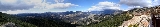
Dead Indian Pass is a mountain pass
in Wyoming
traversed by Wyoming Highway 296. The pass is located along Chief Joseph Scenic Byway
and crosses the Absaroka Range
.
Mountain pass
A mountain pass is a route through a mountain range or over a ridge. If following the lowest possible route, a pass is locally the highest point on that route...
in Wyoming
Wyoming
Wyoming is a state in the mountain region of the Western United States. The western two thirds of the state is covered mostly with the mountain ranges and rangelands in the foothills of the Eastern Rocky Mountains, while the eastern third of the state is high elevation prairie known as the High...
traversed by Wyoming Highway 296. The pass is located along Chief Joseph Scenic Byway
Chief Joseph Scenic Byway
Wyoming Highway 296 also known as the Chief Joseph Scenic Highway is in the U.S. state of Wyoming and follows the route taken by Chief Joseph as he led the Nez Perce Indians out of Yellowstone National Park and into Montana in 1877 during their attempt to flee the U.S...
and crosses the Absaroka Range
Absaroka Range
The Absaroka Range is a sub-range of the Rocky Mountains in the United States. The range stretches about 150 mi across the Montana-Wyoming border, forming the eastern boundary of Yellowstone National Park and the western side of the Bighorn Basin. The range borders the Beartooth Mountains...
.