
Dawson Falls
Encyclopedia
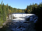
Dawson Falls is one of seven waterfall
s on the Murtle River
in Wells Gray Provincial Park
, British Columbia
, Canada.
Dawson Falls was named in 1913 by land surveyor Robert Henry Lee after George Herbert Dawson, the Surveyor-General for British Columbia from 1912-1917. Lee and his crew camped near Dawson Falls during the summers of 1913 and 1914 while they surveyed homesteaders' lots along the south side of the Murtle River. On July 24, 1913, Lee was surveying west from Dawson Falls when he discovered Helmcken Falls
.
The Wells Gray Park road passes close to Dawson Falls. The main viewpoint is a 10-minute walk and it is another few minutes to the top of the waterfall. A rough trail on the north side of the Murtle River provides a different vantage point. Pyramid Campground, one of four campgrounds in Wells Gray Park, is just northeast of Dawson Falls and has 50 sites.
At Dawson Falls, the Murtle River drops over lava flows that date to about 200,000 years ago. Below the lava are compacted sand and gravel deposits left by a river that predated the eruption.
The Mushbowl is located 600 m (1,969 ft) downstream from Dawson Falls. The Murtle River drops 5 m (16 ft) here and is split by a central rock. The waterfall is located here because of Cambrian rock which has resisted erosion. The Wells Gray Park road bridges the Murtle River at The Mushbowl. The swirling water has eroded a small cave into the cliff on the south side of The Mushbowl and it can be entered at low water from July onwards. The Mushbowl's name was given to this waterfall prior to 1940 and it is a good description of the water's action. Until the late 1960s, a second name "Devil's Punchbowl" was sometimes heard, but was phased out because The Mushbowl is a unique name.
Waterfall
A waterfall is a place where flowing water rapidly drops in elevation as it flows over a steep region or a cliff.-Formation:Waterfalls are commonly formed when a river is young. At these times the channel is often narrow and deep. When the river courses over resistant bedrock, erosion happens...
s on the Murtle River
Murtle River
The Murtle River is a river in east-central British Columbia, Canada. It rises from a large unnamed glacier in the Cariboo Mountains at an elevation of and flows southwest for to the head of gigantic Murtle Lake. The river also drains Murtle Lake then flows southwest for into the Clearwater...
in Wells Gray Provincial Park
Wells Gray Provincial Park
Wells Gray Provincial Park is a large wilderness park located in east-central British Columbia, Canada. The park protects most of the southern, and highest, regions of the Cariboo Mountains and covers 5,250 square kilometres...
, British Columbia
British Columbia
British Columbia is the westernmost of Canada's provinces and is known for its natural beauty, as reflected in its Latin motto, Splendor sine occasu . Its name was chosen by Queen Victoria in 1858...
, Canada.
Dawson Falls was named in 1913 by land surveyor Robert Henry Lee after George Herbert Dawson, the Surveyor-General for British Columbia from 1912-1917. Lee and his crew camped near Dawson Falls during the summers of 1913 and 1914 while they surveyed homesteaders' lots along the south side of the Murtle River. On July 24, 1913, Lee was surveying west from Dawson Falls when he discovered Helmcken Falls
Helmcken Falls
Helmcken Falls is a waterfall on the Murtle River within Wells Gray Provincial Park in British Columbia, Canada. The protection of Helmcken Falls was one of the reasons for the creation of Wells Gray Provincial Park in 1939....
.
The Wells Gray Park road passes close to Dawson Falls. The main viewpoint is a 10-minute walk and it is another few minutes to the top of the waterfall. A rough trail on the north side of the Murtle River provides a different vantage point. Pyramid Campground, one of four campgrounds in Wells Gray Park, is just northeast of Dawson Falls and has 50 sites.
At Dawson Falls, the Murtle River drops over lava flows that date to about 200,000 years ago. Below the lava are compacted sand and gravel deposits left by a river that predated the eruption.
The Mushbowl is located 600 m (1,969 ft) downstream from Dawson Falls. The Murtle River drops 5 m (16 ft) here and is split by a central rock. The waterfall is located here because of Cambrian rock which has resisted erosion. The Wells Gray Park road bridges the Murtle River at The Mushbowl. The swirling water has eroded a small cave into the cliff on the south side of The Mushbowl and it can be entered at low water from July onwards. The Mushbowl's name was given to this waterfall prior to 1940 and it is a good description of the water's action. Until the late 1960s, a second name "Devil's Punchbowl" was sometimes heard, but was phased out because The Mushbowl is a unique name.
See also
- Clearwater RiverClearwater River (British Columbia)The Clearwater River is the largest tributary of the North Thompson River, joining it at the community of Clearwater, British Columbia. The Clearwater rises from glaciers in the Cariboo Mountains and flows in a mostly southerly direction for to the North Thompson. Its entire course, except the...
- Majerus FallsMajerus FallsMajerus Falls is one of seven waterfalls on the Murtle River west of Murtle Lake in Wells Gray Provincial Park, east-central British Columbia, Canada.Majerus Falls is high and wide, a similar width to Dawson Falls downstream....
- Spahats FallsSpahats FallsSpahats Creek Falls, also called Spahats Falls, is a waterfall on Spahats Creek within Wells Gray Provincial Park of British Columbia, Canada. Common references place the falls at around tall, but taking into account the second tier, it is closer to 75–80 meters tall...