

Dar al-Manasir
Encyclopedia
Nile
The Nile is a major north-flowing river in North Africa, generally regarded as the longest river in the world. It is long. It runs through the ten countries of Sudan, South Sudan, Burundi, Rwanda, Democratic Republic of the Congo, Tanzania, Kenya, Ethiopia, Uganda and Egypt.The Nile has two major...
. It is the homeland of the Arab
Arab
Arab people, also known as Arabs , are a panethnicity primarily living in the Arab world, which is located in Western Asia and North Africa. They are identified as such on one or more of genealogical, linguistic, or cultural grounds, with tribal affiliations, and intra-tribal relationships playing...
tribe of the Manasir
Manasir
The Manasir people constitute one of many Sunni Arab riverine tribes of Northern Sudan. They are not to be confused with the Al Manaseer of the Gulf region in the Arabian Peninsula based mainly in the United Arab Emirates. They inhabit the region of the Fourth Cataract of the Nile and call their...
and from them gets its name. Still today the water rapids cannot be crossed by any large boats making the region accessible only via a sandy and rocky desert track.
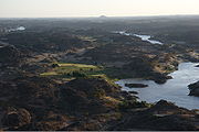
At the height of the Island of Muqrat (N 19°30') the Nile
Nile
The Nile is a major north-flowing river in North Africa, generally regarded as the longest river in the world. It is long. It runs through the ten countries of Sudan, South Sudan, Burundi, Rwanda, Democratic Republic of the Congo, Tanzania, Kenya, Ethiopia, Uganda and Egypt.The Nile has two major...
river is blocked from its northward course taking a sharp turn SSW for 280 kilometres before continuing to flow north. In the middle of this S-shape between the Bayudah Desert to the south and the Nubian Desert
Nubian Desert
The Nubian Desert is in the eastern region of the Sahara Desert, spanning approximately 400,000 km² of northeastern Sudan between the Nile and the Red Sea. The arid region, a largely sandstone plateau, has lots of wadis flowing towards the Nile. There is virtually no rainfall in the Nubian,...
to the north, the Nile is forced by the topography
Topography
Topography is the study of Earth's surface shape and features or those ofplanets, moons, and asteroids...
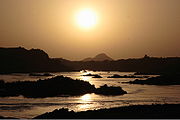
to split up into a multitude of tributaries forming a fertile river oasis of small rocky islands described by the traveller GRAY (1949:120) with the following words: "Whereas usually [agriculture] in the Nile Valley […] is confined to the belt on two banks on which the river has deposited silt
Silt
Silt is granular material of a size somewhere between sand and clay whose mineral origin is quartz and feldspar. Silt may occur as a soil or as suspended sediment in a surface water body...
, in this cataract
Cataract
A cataract is a clouding that develops in the crystalline lens of the eye or in its envelope, varying in degree from slight to complete opacity and obstructing the passage of light...
area, where islands are scattered like a flock of goats, the number of silt-covered river banks in any given 10 kilometres may be up to a dozen".
Dar al-Manasir will be successively flooded by the Merowe Dam
Merowe Dam
The Merowe Dam, also known as Merowe High Dam, Merowe Multi-Purpose Hydro Project or Hamdab Dam, is a large dam near Merowe Town in northern Sudan, about north of the capital Khartoum. Its dimensions make it the largest contemporary hydropower project in Africa...
project.
Extent
Rubatab
-Communication:The Rubatab tribe is a tribe in Sudan that speaks in Arabic. Their accent is different from other tribes in Sudan, but the language is the same, including the alphabets. People from other tribes may have difficulty understanding them because of their distinct accent.People in Rubatab...
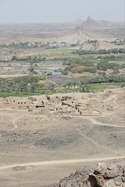
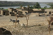
tribe (الرباطاب) in the area of Abu Hamed (أبو حمد) (E 33.18°) and the downstream Shaiqiyah tribe (الشايقية) past the village of Birti (E 32.15°), (cf. LAGNAH 2005:2). Dar al-Manasir is covering a distance of approximately 130 km along the Nile with most villages lined up along the left river bank called "western side" (…). But the heart of Dar al-Manasir consists of 14 islands, twelve of them permanently inhabited; al-Qanaweit (القناويت), Shiri (شري), Kidir (كدر), Sherari (شرري), Sur (سور), Us (اوز), Tibit (…), Dumag (دماج), Buni (بوني), Arag (ارج), Dirbi (دربي) and Birti (برتي), (cf. SALIH 1999:8, LAGNAH 2005:2).
Climate
Economy
Date Palm
The date palm is a palm in the genus Phoenix, cultivated for its edible sweet fruit. Although its place of origin is unknown because of long cultivation, it probably originated from lands around the Persian Gulf. It is a medium-sized plant, 15–25 m tall, growing singly or forming a clump with...
s (cf. Date cultivation in Dar al-Manasir
Date cultivation in Dar al-Manasir
Date palms are cultivated in Sudan from the Egyptian border in the North all the way along the Nile south of Khartoum until Sennar. In addition to the banks of the Nile, isolated occurrences of cultivated date trees occur in the Red Sea Hills in the vicinity of Port Sudan, in Kassala, along the...
). During good rainy seasons, in which grazing grounds are abundant, many male Manasir join members of their tribe in the adjacent Bayudah Desert.
Administration
Dar al-Manasir is among the most neglected areas in Northern Sudan
Sudan
Sudan , officially the Republic of the Sudan , is a country in North Africa, sometimes considered part of the Middle East politically. It is bordered by Egypt to the north, the Red Sea to the northeast, Eritrea and Ethiopia to the east, South Sudan to the south, the Central African Republic to the...
. Apart from basic educational institutions virtually no public infrastructure such as tarred roads, bridges or ferry boats and hospitals exist. But the Manasir are also aware of advantages of this situation and describe them in terms of exceptional safety and honesty (في أمان), tranquillity (الجوّ هادئ و نظيف), untainted beauty of their country (البلد سمح) and cleanness of the water which they drink straight out of the Nile. The landscape, described by Innes (1931:184) as "most barren and the most beautiful" along the Nile, is rocky, picturesque and referred by the inhabitants happily as "our rocks" (حجرنا).
Dar al-Manasir with all its villages and agricultural land will be successively flooded in the coming months by the Merowe Dam
Merowe Dam
The Merowe Dam, also known as Merowe High Dam, Merowe Multi-Purpose Hydro Project or Hamdab Dam, is a large dam near Merowe Town in northern Sudan, about north of the capital Khartoum. Its dimensions make it the largest contemporary hydropower project in Africa...
project. Its residents are going to be moved, but the exact relocation area is still not clear and a matter of ongoing discussion.
See also
- Al-Hakem, A.M.A. (1993): "Merowe (Hamdab) High Dam and its Impacts". In: Kush XVI, 25 p.
- Beck. K. (1997): "Wer kennt schon Hamdab? Ein Staudammvorhaben im Sudan". In: Pörtge, K.-H. (ed.): Forschungen im Sudan. Erfurter Geographische Studien, Bd.5, pp.79–88.
- Beck, K. (1999): "Escaping from the Narrow Confines – Returning to Tight Communities. Manasir Labour Migration from the Area of the Fourth Nile Cataract". In: Hahn, H.P. & G. Spittler (ed.): Afrika und die Globalisierung, pp. 201–211.
- Beck, K. (2001): "Die Aneignung der Maschine". In: Kohl, K.-H. & N. Schafhausen (ed.): New Heimat. Katalog zur Ausstellung im Frankfurter Kunstverein, pp. 66–77.
- Cavendish, M. W. (1966): "The Custom of Placing Pebbles on Nubian Graves". In: Sudan Notes and Records, Vol.47. pp. 151–156.
- Corkill N.L. (1948): "Weight Equivalent of Sudan Foods sold by Measures of Capacity". In: Sudan Notes and Records, Vol.29, pp. 126–127.
- Crowfoot, J. W. (1918): "Customs of the Rubatab". In: Sudan Notes and Records, Vol.1. pp. 119–134.
- Gray, T. (1949): "The Fourth Cataract". In: Sudan Notes and Records, Vol.30, p.120-121.
- Innes, N. McL. (1930): "The Monasir Country". In: Sudan Notes and Records, Vol.14, pp. 185–191.
- Jackson, H.C. (1926): "A Trek in Abu Hamed District". In: Sudan Notes and Records, Vol.9 No.2, pp. 1–35.
- Lagnah aL-Tanfidhiyah lil-Muta'thirin (2005): Khasan al-Hamdab wa Qissah Tahgir Ahali al-Manasir. pp. 20 (اللجنة التنفيذية للمتأثرين (2005): خزان الحامداب و قصة تهجير أهالي المناصير)
- Leach, T.A. (1919): "Date-Trees in Halfa Province". In: Sudan Notes and Records, Vol.2, pp. 98–104.
- Nicholls, W. (1918): "The Sakia in Dongola Province". In: Sudan Notes and Records, Vol.1. pp.21–24.
Related books
- Bashir, al-N. T. al-S. (ed.), (1997): Diwan 'Abqariah al-Manasir. Li-Ustadh Ibrahim 'Ali al-Sha'ir. 189 p. (النذير تاج السر البشير(جمع وإعداد), (1997): ديوان عبقرية المناصير. للأستاذ إبراهيم علي الشاعر)
- Qasim, 'A. al-ShAwn Alsharif QasimAwn Al-Sharif Qasim - * - was a prolific Sudanese writer, encyclopedist, a prominent scholar, a powerful community leader, a man of charity and one of Sudan's leading experts on Arabic language and literature....
. (2002): Qamus al-Lahgah al-'Amiya fi al-Sudan, 3rd ed. 1076 p. (عون الشريف قاسم (2002): قاموس اللهجة العامية في السودان. الطبعة الثالثة. الدار السودانية للكتب) - Salih, A. M. (1999): The Manasir of the Northern Sudan: Land and People. A Riverain Society and Resource Scarcity. 282 p.
- Taiyeb, M. Al-T. et al. (1969): Al-Turath al-Sha'ibi li-Qabilah al-Manasir. Salsalah Dirasat fi al-Turath al-Sudani. Khartoum University Faculty of Adab. 155 p. (الطيب محمد الطيب و عبد السلام سليمان و علي سعد (1969): التراث الشعبي لقبيلة المناصير. سلسلة دراسات في التراث السوداني ,جامعة الخرطوم, كلية الآداب)
- Yusif, A.A. (1995): Al-Nakhil (First Part), Khartoum. 349 p. (عبدلله أحمد يوسف (1995): النخيل – الجزء الأولى الخرطوم)