

Danube Sinkhole
Encyclopedia
Immendingen
Immendingen is a town in the district of Tuttlingen in Baden-Württemberg in Germany....
and Möhringen and also near Fridingen
Fridingen
Fridingen is a town in the district of Tuttlingen, in Baden-Württemberg, Germany. It is situated on the Danube, 10 km east of Tuttlingen, and 23 km west of Sigmaringen....
(Tuttlingen
Tuttlingen
Tuttlingen is a town in Baden-Württemberg, capital of the district Tuttlingen. Nendingen, Möhringen and Eßlingen are three former municipalities that belong to Tuttlingen...
), the water of the Danube
Danube
The Danube is a river in the Central Europe and the Europe's second longest river after the Volga. It is classified as an international waterway....
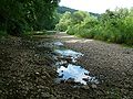
sinks into the riverbed in various places. The main sinkhole
Sinkhole
A sinkhole, also known as a sink, shake hole, swallow hole, swallet, doline or cenote, is a natural depression or hole in the Earth's surface caused by karst processes — the chemical dissolution of carbonate rocks or suffosion processes for example in sandstone...
is next to a field named Brühl between Immendingen and Moehringen.
The term "sinking" is more accurate then "seeping", because the water is not easily distributed in the soil. It flows through underground caverns to Aachtopf
Aachtopf
The Aachtopf is Germany's biggest natural spring, producing an average of 8,500 litres per second. Production varies seasonally and in response to the weather, but the spring never runs dry...
, where it emerges as the river Radolfzeller Aach
Radolfzeller Aach
The Radolfzeller Aach is a right or north tributary of the Rhine in the south of Baden-Württemberg .It is approximately 32 km long.- Course :...
.
Hydrography
The sinking Danube water disappears into a karstKARST
Kilometer-square Area Radio Synthesis Telescope is a Chinese telescope project to which FAST is a forerunner. KARST is a set of large spherical reflectors on karst landforms, which are bowlshaped limestone sinkholes named after the Kras region in Slovenia and Northern Italy. It will consist of...
water system of the well-stratified limestone formation (the ox2 layer) of the White Jura and appears again in a horizontal limestone layer (the ki4 layer), approximately twelve kilometers away at Aachtopf
Aachtopf
The Aachtopf is Germany's biggest natural spring, producing an average of 8,500 litres per second. Production varies seasonally and in response to the weather, but the spring never runs dry...
. It then flows as Radolfzeller Aach
Radolfzeller Aach
The Radolfzeller Aach is a right or north tributary of the Rhine in the south of Baden-Württemberg .It is approximately 32 km long.- Course :...
into Lake Constance
Lake Constance
Lake Constance is a lake on the Rhine at the northern foot of the Alps, and consists of three bodies of water: the Obersee , the Untersee , and a connecting stretch of the Rhine, called the Seerhein.The lake is situated in Germany, Switzerland and Austria near the Alps...
at Radolfzell
Radolfzell
Radolfzell am Bodensee is a town in Germany at the western end of Lake Constance approximately 18 km northwest of Konstanz. It is the third largest town, after Constance and Singen, in the district of Konstanz, in Baden-Württemberg....
. Thus, a part of the Danube water also flows into the Rhine. This geographical situation is a striking feature of the large European Watershed
European Watershed
The European Watershed is the line which divides the drainage basins of the major rivers of Germany: the Rhine, which originates in the Swiss Alps and empties into the North Sea via the Netherlands, and the Danube, which originates in the Black Forest and flows eastward emptying into the Black...
, which separates the catchment areas of the North Sea
North Sea
In the southwest, beyond the Straits of Dover, the North Sea becomes the English Channel connecting to the Atlantic Ocean. In the east, it connects to the Baltic Sea via the Skagerrak and Kattegat, narrow straits that separate Denmark from Norway and Sweden respectively...
and the Black Sea
Black Sea
The Black Sea is bounded by Europe, Anatolia and the Caucasus and is ultimately connected to the Atlantic Ocean via the Mediterranean and the Aegean seas and various straits. The Bosphorus strait connects it to the Sea of Marmara, and the strait of the Dardanelles connects that sea to the Aegean...
.
The water flows out through a variety of small to very small cracks and crevices; the karst
KARST
Kilometer-square Area Radio Synthesis Telescope is a Chinese telescope project to which FAST is a forerunner. KARST is a set of large spherical reflectors on karst landforms, which are bowlshaped limestone sinkholes named after the Kras region in Slovenia and Northern Italy. It will consist of...
in these places is apparently at an early stage of development. The cave system of Aachtopf, that is the underground river Danube is, however, probably already well developed. The can be inferred from the tight correlation
Correlation
In statistics, dependence refers to any statistical relationship between two random variables or two sets of data. Correlation refers to any of a broad class of statistical relationships involving dependence....
in water temperatures of the Danube and Aachtopf spring which matches the behaviour of an underground river better than a branching system.
In the 1960s, Jochen Hasenmayer has discovered and explored the first 400 meters of a large clam-shaped hole called the Aachhöhle.
History
The first documented case of the Danube completely disappearing into the hole, dates back to 1874. Since then, the number of days per year when this happens, has risen sharply. Between 1884 and 1904, it happened, on average, 80 days per year. In 1922, it happened only on 29 days. In 1923, however, the number increased to 148. Between 1933 and 1937, the average was on 209; from 1938 to 1945, it was 270 days. The highest number so far, was in 1921, with 309 days.The relationship between the sinkhole and Aachtopf
Aachtopf
The Aachtopf is Germany's biggest natural spring, producing an average of 8,500 litres per second. Production varies seasonally and in response to the weather, but the spring never runs dry...
spring was proven in October 1877. Geologist Adolf Knop of the Karlsruhe Institute of Technology
Karlsruhe Institute of Technology
The Karlsruhe Institute of Technology is a German academic research and education institution with university status resulting from a merger of the university and the research center of the city of Karlsruhe. The university, also known as Fridericiana, was founded in 1825...
poured 10 kg of sodium fluorescein, 20 tons of salt
Sodium chloride
Sodium chloride, also known as salt, common salt, table salt or halite, is an inorganic compound with the formula NaCl. Sodium chloride is the salt most responsible for the salinity of the ocean and of the extracellular fluid of many multicellular organisms...
, and 1200 kg of shale oil
Shale oil
Shale oil, known also as kerogen oil or oil-shale oil, is an unconventional oil produced from oil shale by pyrolysis, hydrogenation, or thermal dissolution. These processes convert the organic matter within the rock into synthetic oil and gas...
into the Danube on 9 October. After 60 hours, all three substances emerged at the Aachtopf. The water at Aachtof was described as "gorgeously green lit" by the fluorescein and tasting of creosote.
Later, the connection of the individual sinkholes was explored. In about 1908, a shaft was dug in Fridingen in an attempt to find out where the water of this sinkhole goes.
In 1927, a case was brought before the Supreme Court of the German Reich between the countries Württemberg
Free People's State of Württemberg
The Free People's State of Württemberg was a state of Germany during the Weimar Republic in Württemberg.-1918 revolution:As Germany underwent violent revolution near the end of World War I, the Kingdom of Württemberg was transformed from a monarchy to a democratic republic without bloodshed; its...
and Prussia
Prussia
Prussia was a German kingdom and historic state originating out of the Duchy of Prussia and the Margraviate of Brandenburg. For centuries, the House of Hohenzollern ruled Prussia, successfully expanding its size by way of an unusually well-organized and effective army. Prussia shaped the history...
as the ruler of the Hohenzollern Province on the one hand and the state of Baden
Baden
Baden is a historical state on the east bank of the Rhine in the southwest of Germany, now the western part of the Baden-Württemberg of Germany....
on the other hand, to decide the smoldering controversy over the quantitative impact of the Danube sinkhole, which is known as Danube Sinkhole case .
Outlook
As the karst is developing, future sinkhole stretches are not exactly predictable. The underground river Danube annually removes about 7,000 tons of lime, that is 2,700 cubic meters, from the karst system. Future expansions or collapses in the underground system are conceivable; these would show above ground as sinkholes or ponorPonor
A ponor is a natural surface opening that may be found in landscapes where the geology and the geomorphology is characterized by some kind of karst....
s.
In the long run today's upper Danube will probably be redirected entirely into Radolfzeller Aach
Radolfzeller Aach
The Radolfzeller Aach is a right or north tributary of the Rhine in the south of Baden-Württemberg .It is approximately 32 km long.- Course :...
, and thus to the Rhine. Then would mean that the currently insignificant tributaries
Tributary
A tributary or affluent is a stream or river that flows into a main stem river or a lake. A tributary does not flow directly into a sea or ocean...
Krähenbach
Krähenbach
The Krähenbach is a tributary of the Danube on the Baar plateau in Tuttlingen in the Upper Danube Nature Park .- Course :The Krähenbach rises some 200 m east of the clay pit in the Haldenwald forest in the municipality of Tuningen district next to a forest road at about...
(in Möhringen) and Elta
Elta (river)
The Elta is a river of Baden-Württemberg, Germany.-See also:*List of rivers of Baden-Württemberg...
(in Tuttlingen
Tuttlingen
Tuttlingen is a town in Baden-Württemberg, capital of the district Tuttlingen. Nendingen, Möhringen and Eßlingen are three former municipalities that belong to Tuttlingen...
) would become the new headwaters of the Danube. The Danube has experienced a similar stream capture further upstream, during the Würm glaciation, when the Feldberg-Danube was captured by the Wutach at the Wutach Gorge near Blumberg
Blumberg
Blumberg is a municipality situated in the Schwarzwald-Baar region of Baden-Württemberg, Germany, 19 kilometres south of Donaueschingen, on the southern edge of the Schwarzwald, The Black Forest and lying directly on the border with Switzerland’s Canton of Schaffhausen.-History:The town of Blumberg...
.
External links
- Nachlese: Report on search for the underground river Danube
- Testimony of the discovery of the Danube cave
- Website about the construction of access to and further exploration of the Danube cave