Dalton metropolitan area
Encyclopedia

United States Census Bureau
The United States Census Bureau is the government agency that is responsible for the United States Census. It also gathers other national demographic and economic data...
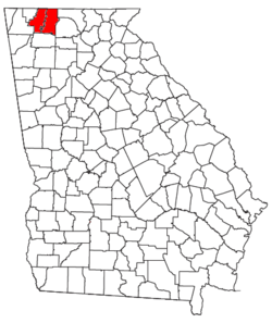
, is an area consisting of two counties in northwestern Georgia
Georgia (U.S. state)
Georgia is a state located in the southeastern United States. It was established in 1732, the last of the original Thirteen Colonies. The state is named after King George II of Great Britain. Georgia was the fourth state to ratify the United States Constitution, on January 2, 1788...
, anchored by the city of Dalton
Dalton, Georgia
Dalton is a city in Whitfield County, Georgia, United States. It is the county seat of Whitfield County and the principal city of the Dalton, Georgia Metropolitan Statistical Area, which encompasses all of both Murray and Whitfield counties. As of the 2010 census, the city had a population of 33,128...
. As of the 2010 census
United States Census, 2010
The Twenty-third United States Census, known as Census 2010 or the 2010 Census, is the current national census of the United States. National Census Day was April 1, 2010 and is the reference date used in enumerating individuals...
, the MSA had a population of 142,227.
Communities
- Carters (unincorporated)
- ChatsworthChatsworth, GeorgiaChatsworth is a city in Murray County, Georgia, United States. It is part of the Dalton, Georgia Metropolitan Statistical Area. The population was 3,531 at the 2000 census, but was estimated around 3,890 as of the 2005 census. The city is the county seat of Murray County...
- Cisco (unincorporated)
- CohuttaCohutta, GeorgiaCohutta is a town in Whitfield County, Georgia, United States. It is part of the Dalton, Georgia Metropolitan Statistical Area. The population was 582 at the 2000 census.-Geography:Cohutta is located at ....
- Crandall (unincorporated)
- DaltonDalton, GeorgiaDalton is a city in Whitfield County, Georgia, United States. It is the county seat of Whitfield County and the principal city of the Dalton, Georgia Metropolitan Statistical Area, which encompasses all of both Murray and Whitfield counties. As of the 2010 census, the city had a population of 33,128...
(Principal city) - EtonEton, GeorgiaEton is a town in Murray County, Georgia, United States. It is part of the Dalton, Georgia Metropolitan Statistical Area. The population was 319 at the 2000 census.-Geography:Eton is located at ....
- Rocky Face (unincorporated)
- Tilton (unincorporated)
- Tunnel HillTunnel Hill, GeorgiaTunnel Hill is a town in northwest Whitfield County, Georgia, United States,and southern Catoosa County, Georgia, United States . It is part of the Dalton, Georgia Metropolitan Statistical Area. The population was 1,209 at the 2000 census.-History:...
- VarnellVarnell, GeorgiaVarnell is a city in Whitfield County, Georgia, United States. It is part of the Dalton, Georgia Metropolitan Statistical Area. The population was 1,491 at the 2000 census.-Geography:Varnell is located at ....
Demographics
As of the censusCensus
A census is the procedure of systematically acquiring and recording information about the members of a given population. It is a regularly occurring and official count of a particular population. The term is used mostly in connection with national population and housing censuses; other common...
of 2000, there were 120,031 people, 42,671 households, and 32,412 families residing within the MSA. The racial makeup of the MSA was 85.30% White, 2.87% African American, 0.33% Native American, 0.71% Asian, 0.03% Pacific Islander, 9.16% from other races
Race (United States Census)
Race and ethnicity in the United States Census, as defined by the Federal Office of Management and Budget and the United States Census Bureau, are self-identification data items in which residents choose the race or races with which they most closely identify, and indicate whether or not they are...
, and 1.59% from two or more races. Hispanic or Latino of any race were 17.02% of the population.
The median income for a household in the MSA was $38,187, and the median income for a family was $43,404. Males had a median income of $29,967 versus $23,372 for females. The per capita income
Per capita income
Per capita income or income per person is a measure of mean income within an economic aggregate, such as a country or city. It is calculated by taking a measure of all sources of income in the aggregate and dividing it by the total population...
for the MSA was $17,373.

