
Daisetsuzan Volcanic Group
Encyclopedia
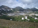
The is a volcanic group
of peaks arranged around the 2 kilometres (1.2 mi) wide caldera
in Hokkaidō
, Japan
. In the Ainu language
it is known as Nutapukaushipe or Nutaku Kamushupe. These peaks are the highest in Hokkaidō. The group lends its name to the Daisetsuzan National Park
in which the volcanic group is located.
on the Kurile arc of the Pacific ring of fire
. The volcanic zone makes itself known through a number of fumaroles and natural hot springs.
Volcanic group
A volcanic group is a collection of related volcanoes or volcanic landforms. Note that the term is also used in a different sense when it denotes a suite of associated rock strata largely of volcanic origin; see group for details.-Notable volcanic groups:-See also:*Complex...
of peaks arranged around the 2 kilometres (1.2 mi) wide caldera
Caldera
A caldera is a cauldron-like volcanic feature usually formed by the collapse of land following a volcanic eruption, such as the one at Yellowstone National Park in the US. They are sometimes confused with volcanic craters...
in Hokkaidō
Hokkaido
, formerly known as Ezo, Yezo, Yeso, or Yesso, is Japan's second largest island; it is also the largest and northernmost of Japan's 47 prefectural-level subdivisions. The Tsugaru Strait separates Hokkaido from Honshu, although the two islands are connected by the underwater railway Seikan Tunnel...
, Japan
Japan
Japan is an island nation in East Asia. Located in the Pacific Ocean, it lies to the east of the Sea of Japan, China, North Korea, South Korea and Russia, stretching from the Sea of Okhotsk in the north to the East China Sea and Taiwan in the south...
. In the Ainu language
Ainu language
Ainu is one of the Ainu languages, spoken by members of the Ainu ethnic group on the northern Japanese island of Hokkaidō....
it is known as Nutapukaushipe or Nutaku Kamushupe. These peaks are the highest in Hokkaidō. The group lends its name to the Daisetsuzan National Park
Daisetsuzan National Park
, or Taisetsuzan is located in the mountainous center of the northern Japanese island of Hokkaidō. At 2267.64 square kilometers, Daisetsuzan is the largest national park in Japan....
in which the volcanic group is located.
Geography
The volcanic group lies at the north end of the Daisetsu-Tokachi grabenGraben
In geology, a graben is a depressed block of land bordered by parallel faults. Graben is German for ditch. Graben is used for both the singular and plural....
on the Kurile arc of the Pacific ring of fire
Pacific Ring of Fire
The Pacific Ring of Fire is an area where large numbers of earthquakes and volcanic eruptions occur in the basin of the Pacific Ocean. In a horseshoe shape, it is associated with a nearly continuous series of oceanic trenches, volcanic arcs, and volcanic belts and/or plate movements...
. The volcanic zone makes itself known through a number of fumaroles and natural hot springs.
List of mountains by height
The following peaks make up the volcanic group:| Name | Height | Type |
|---|---|---|
| 2290 metres (7,513.1 ft) | stratovolcano | |
| 2244 metres (7,362.2 ft) | lava dome | |
| 2230 metres (7,316.3 ft) | lava dome | |
| 2210 metres (7,250.7 ft) | stratovolcano | |
| 2197 metres (7,208 ft) | volcanic | |
| 2185 metres (7,168.6 ft) | caldera rim | |
| 2158 metres (7,080.1 ft) | stratovolcano | |
| 2149 metres (7,050.5 ft) | caldera rim | |
| 2142 metres (7,027.6 ft) | volcanic | |
| 2136 metres (7,007.9 ft) | caldera rim | |
| 2125 metres (6,971.8 ft) | lava dome | |
| 2113 metres (6,932.4 ft) | caldera rim | |
| 2112.7 metres (6,931.4 ft) | volcanic | |
| 2078.5 metres (6,819.2 ft) | stratovolcano | |
| 2072 metres (6,797.9 ft) | stratovolcano | |
| 2038 metres (6,686.4 ft) | - | |
| 2019.9 metres (6,627 ft) | - | |
| 1984.3 metres (6,510.2 ft) | lava dome | |
| 1978 metres (6,489.5 ft) | stratovolcano | |
| 1938 metres (6,358.3 ft) | lava dome |