
Cyclone Zoe
Encyclopedia
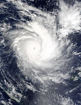
Severe Tropical Cyclone Zoe (RSMC Nadi designation:04F, JTWC designation:06P) was the most intense tropical cyclone recorded in the Southern Hemisphere.
in Nadi, Fiji reported that Tropical Depression 04F had formed about 665 km, (415 mi), to the east of Tuvalu
. The depression at this time was emerging from the South Pacific Convergence Zone
and was being steered to the west-southwest under the influence of a mid-level ridge of high pressure to the south of the system. Over the next couple of days the depression slowly organized before a tropical cyclone formation alert
was issued early on December 25 after the system had crossed the International Dateline. Later that day the JTWC reported that the depression had intensified into Tropical Cyclone 06P with winds equivalent to a weak tropical storm. Later that day RSMC Nadi reported that the depression had intensified into a tropical cyclone and named it as Zoe.
Late on December 23, 2002 a tropical disturbance was identified within a trough of low pressure that was located within the South Pacific Convergence Zone
, which was located about 665km (415miles) to the east of Tuvalu, and was assigned the designation of 04F by the Regional Specialized Meteorological Centre
located in Nadi, Fiji. Late the next day as deep convection had picked up around the centre of the disturbance; RSMC Nadi upgraded the disturbance to a tropical depression and then early on December 25, a Tropical Cyclone Formation Alert
was issued by the Joint Typhoon Warning Center
as the depression was expected to become a significant tropical cyclone within 24 hours. During the afternoon of December 25, the JTWC designated the depression as Tropical Cyclone 06P, whilst later that day at 2100 UTC (0900 FST) RSMC Nadi upgraded the Tropical depression to a Tropical Cyclone and named it as Cyclone Zoe.
During the next morning RSMC Nadi noted that Zoe had continued to intensified and had become a category 2 cyclone. During that afternoon the JTWC reported that Zoe had winds off 75 knots (85 mph, 135 km/h) which made Cyclone Zoe a category one Cyclone on the Saffir-Simpson Hurricane Scale Early on December 27 RSMC Nadi reported that Zoe had rapidly intensified in to a strong category four severe tropical cyclone, with winds of 110 knots whilst the JTWC reported that Zoe was only a strong category one cyclone on the SSHS.
During the afternoon of December 27 both RSMC Nadi & the JTWC reported that Severe Tropical Cyclone Zoe, had intensified in to a category five cyclone, on both the Australian cyclone intensity scale and the Saffir Simpson Huricanne Scale. RSMC Nadi reported at this time that Zoe had 10 minute maximum sustained winds of 120 knots whilst the JTWC reported that Zoe had reached it peak 1 minute maximum sustained winds of 155 knots Early the next day RSMC Nadi reported that Zoe had continued to intensify and had reached winds of 130 knots.
Between December 28 and December 29, Zoe moved very little, executing a small clockwise loop whilst maintaining its general intensity. During that time it passed over several small islands in the Temotu Province
of the Solomon Islands
. December 29 saw Zoe moving again, this time to the southeast. At this time, it encountered an unfavourable environment of increasing wind shear and colder waters, and began to weaken. Zoe was downgraded to a tropical depression early at the start of the new year, January 1, 2003, when it was located about 210 nautical miles (388.9 km) to the southwest of Nadi. Warnings were discontinued that day, as Zoe became extratropical.
The most severe damage wrought by Zoe took place on Tikopia
which was completely decimated. Across Tikopia, no home was left standing after 12 m (39.4 ft) waves along with 320 km/h (198.8 mph) winds battered the small island. According to press reports, the island was faced with total devastation and all that remained was "just sand and debris." Five days after the storm struck, there were fears of substantial loss of life as no contact had been made with the hardest hit islands. A photographer who took images of the devastation from the air, stated that it would be a miracle if there was not a large loss of life.
On Anuta
90% of houses remained intact, and 70% of crops undamaged. Communication was lost with the island for a week. Vanuatu
was inundated with seawater with villagers collecting fish from their village greens. No damage was reported on Fiji with a maximum sustained wind of 33 kn (64.7 km/h) at Yasawa, and a gust of 40 kn (78.4 km/h) at Nadi.
Supplies were delayed for days by Solomon Island police as they requested further pay before shipping supplies to the islands. Against the millions of dollars pledged by Australia, only $270,000 had been provided by January 4.
Meteorological history
Late on December 23, 2002 the Regional Specialized Meteorological CentreRegional Specialized Meteorological Centre
A Regional Specialized Meteorological Centre is responsible for the distribution of information, advisories, and warnings regarding the specific program they have a part of, agreed by consensus at the World Meteorological Organization as part of the World Weather Watch.-Tropical...
in Nadi, Fiji reported that Tropical Depression 04F had formed about 665 km, (415 mi), to the east of Tuvalu
Tuvalu
Tuvalu , formerly known as the Ellice Islands, is a Polynesian island nation located in the Pacific Ocean, midway between Hawaii and Australia. Its nearest neighbours are Kiribati, Nauru, Samoa and Fiji. It comprises four reef islands and five true atolls...
. The depression at this time was emerging from the South Pacific Convergence Zone
South Pacific convergence zone
The South Pacific Convergence Zone , a reverse-oriented monsoon trough, is a band of low-level convergence, cloudiness and precipitation extending from the west Pacific warm pool south-eastwards towards French Polynesia...
and was being steered to the west-southwest under the influence of a mid-level ridge of high pressure to the south of the system. Over the next couple of days the depression slowly organized before a tropical cyclone formation alert
Tropical Cyclone Formation Alert
A Tropical Cyclone Formation Alert is a bulletin released by the U.S. Navy-operated Joint Typhoon Warning Center in Honolulu, Hawaii or the Naval Maritime Forecast Center in Norfolk, Virginia, warning of the possibility of a tropical cyclone forming from a tropical disturbance that has been...
was issued early on December 25 after the system had crossed the International Dateline. Later that day the JTWC reported that the depression had intensified into Tropical Cyclone 06P with winds equivalent to a weak tropical storm. Later that day RSMC Nadi reported that the depression had intensified into a tropical cyclone and named it as Zoe.
Late on December 23, 2002 a tropical disturbance was identified within a trough of low pressure that was located within the South Pacific Convergence Zone
South Pacific convergence zone
The South Pacific Convergence Zone , a reverse-oriented monsoon trough, is a band of low-level convergence, cloudiness and precipitation extending from the west Pacific warm pool south-eastwards towards French Polynesia...
, which was located about 665km (415miles) to the east of Tuvalu, and was assigned the designation of 04F by the Regional Specialized Meteorological Centre
Regional Specialized Meteorological Centre
A Regional Specialized Meteorological Centre is responsible for the distribution of information, advisories, and warnings regarding the specific program they have a part of, agreed by consensus at the World Meteorological Organization as part of the World Weather Watch.-Tropical...
located in Nadi, Fiji. Late the next day as deep convection had picked up around the centre of the disturbance; RSMC Nadi upgraded the disturbance to a tropical depression and then early on December 25, a Tropical Cyclone Formation Alert
Tropical Cyclone Formation Alert
A Tropical Cyclone Formation Alert is a bulletin released by the U.S. Navy-operated Joint Typhoon Warning Center in Honolulu, Hawaii or the Naval Maritime Forecast Center in Norfolk, Virginia, warning of the possibility of a tropical cyclone forming from a tropical disturbance that has been...
was issued by the Joint Typhoon Warning Center
Joint Typhoon Warning Center
The Joint Typhoon Warning Center is a joint United States Navy – United States Air Force task force located at the Naval Maritime Forecast Center in Pearl Harbor, Hawaii...
as the depression was expected to become a significant tropical cyclone within 24 hours. During the afternoon of December 25, the JTWC designated the depression as Tropical Cyclone 06P, whilst later that day at 2100 UTC (0900 FST) RSMC Nadi upgraded the Tropical depression to a Tropical Cyclone and named it as Cyclone Zoe.
During the next morning RSMC Nadi noted that Zoe had continued to intensified and had become a category 2 cyclone. During that afternoon the JTWC reported that Zoe had winds off 75 knots (85 mph, 135 km/h) which made Cyclone Zoe a category one Cyclone on the Saffir-Simpson Hurricane Scale Early on December 27 RSMC Nadi reported that Zoe had rapidly intensified in to a strong category four severe tropical cyclone, with winds of 110 knots whilst the JTWC reported that Zoe was only a strong category one cyclone on the SSHS.
During the afternoon of December 27 both RSMC Nadi & the JTWC reported that Severe Tropical Cyclone Zoe, had intensified in to a category five cyclone, on both the Australian cyclone intensity scale and the Saffir Simpson Huricanne Scale. RSMC Nadi reported at this time that Zoe had 10 minute maximum sustained winds of 120 knots whilst the JTWC reported that Zoe had reached it peak 1 minute maximum sustained winds of 155 knots Early the next day RSMC Nadi reported that Zoe had continued to intensify and had reached winds of 130 knots.
Between December 28 and December 29, Zoe moved very little, executing a small clockwise loop whilst maintaining its general intensity. During that time it passed over several small islands in the Temotu Province
Temotu Province
Temotu is the easternmost province of the Solomon Islands. The province was formerly known as Santa Cruz Islands Province. It consists, essentially, of two chains of islands which run parallel to each other from the northwest to the southeast.- Islands :...
of the Solomon Islands
Solomon Islands
Solomon Islands is a sovereign state in Oceania, east of Papua New Guinea, consisting of nearly one thousand islands. It covers a land mass of . The capital, Honiara, is located on the island of Guadalcanal...
. December 29 saw Zoe moving again, this time to the southeast. At this time, it encountered an unfavourable environment of increasing wind shear and colder waters, and began to weaken. Zoe was downgraded to a tropical depression early at the start of the new year, January 1, 2003, when it was located about 210 nautical miles (388.9 km) to the southwest of Nadi. Warnings were discontinued that day, as Zoe became extratropical.
Impact
Although Zoe never met large land masses, it did affect several inhabited islands which had a total population of around 1700.The most severe damage wrought by Zoe took place on Tikopia
Tikopia
Tikopia is a small and high island in the southwestern Pacific Ocean. Covering an area of 5 km² , the island is the remnant of an extinct volcano. Its highest point, Mt. Reani, reaches an elevation of 380 m above sea level. Lake Te Roto covers an old volcanic crater which is 80 m...
which was completely decimated. Across Tikopia, no home was left standing after 12 m (39.4 ft) waves along with 320 km/h (198.8 mph) winds battered the small island. According to press reports, the island was faced with total devastation and all that remained was "just sand and debris." Five days after the storm struck, there were fears of substantial loss of life as no contact had been made with the hardest hit islands. A photographer who took images of the devastation from the air, stated that it would be a miracle if there was not a large loss of life.
On Anuta
Anuta
Anuta is a small high island in the southeastern part of the Solomon Islands province of Temotu, the smallest permanently inhabited isolated Polynesian island.-Description:...
90% of houses remained intact, and 70% of crops undamaged. Communication was lost with the island for a week. Vanuatu
Vanuatu
Vanuatu , officially the Republic of Vanuatu , is an island nation located in the South Pacific Ocean. The archipelago, which is of volcanic origin, is some east of northern Australia, northeast of New Caledonia, west of Fiji, and southeast of the Solomon Islands, near New Guinea.Vanuatu was...
was inundated with seawater with villagers collecting fish from their village greens. No damage was reported on Fiji with a maximum sustained wind of 33 kn (64.7 km/h) at Yasawa, and a gust of 40 kn (78.4 km/h) at Nadi.
Aftermath
Within days of Zoe's passage, the government of the Solomon Islands declared the affected islands disaster zones. Relief supplies were sent from Honiara by January 5 and international aid followed shortly thereafter. Requests for assistance from New Zealand, Australia and France were made by the Solomon Islands. For nearly a week, residents on Tikopia survived without aid by drinking coconut milk and eating what remained of their food stocks. The first relief vessel finally arrived in the island on January 6, bringing medical supplies and food. Although the island's residents had no warning prior to Zoe's arrival, it was found that they took notice of natural warning signs and sought shelter in caves, resulting in no loss of life. Additional supplies were shipped to Anuta on January 6 by a local ship.Supplies were delayed for days by Solomon Island police as they requested further pay before shipping supplies to the islands. Against the millions of dollars pledged by Australia, only $270,000 had been provided by January 4.