
Currant Mountain
Encyclopedia
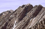
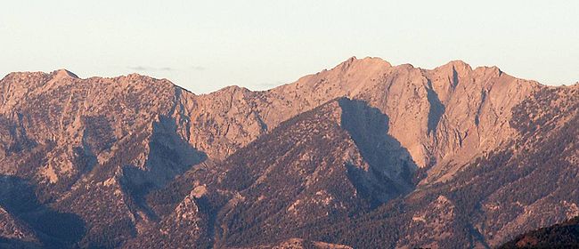
Currant Mountain is the high point on the southern crest of the White Pine Range
, on the border between southwest White Pine
and northeast Nye
Counties, in east-central Nevada
in the western United States
. It comprises a series of three spires on a thin limestone ridge, with the southern spire being the highest at 11518 feet (3,511 m). To the west are the Duckwater (Shoshone
) tribal lands and the northern arm of large Railroad Valley
. To the east is the northern part of White River Valley
. The peak is located about 37 miles (60 km) southwest of the community of Ely
.
White Pine Range
The White Pine Range is a group of mountains in southern White Pine County, in eastern Nevada. The range runs for approximately 51 miles from Beck Pass in the north to Currant Pass in the south. To the west of the range are the Duckwater tribal lands and the northern arm of large Railroad Valley...
, on the border between southwest White Pine
White Pine County, Nevada
White Pine County is a county located in the U.S. state of Nevada. Its population at the 2010 census was 10,030. Its county seat is Ely. It is the home of Great Basin National Park...
and northeast Nye
Nye County, Nevada
-National protected areas:* Ash Meadows National Wildlife Refuge* Death Valley National Park * Humboldt-Toiyabe National Forest * Spring Mountains National Recreation Area -Demographics:...
Counties, in east-central Nevada
Nevada
Nevada is a state in the western, mountain west, and southwestern regions of the United States. With an area of and a population of about 2.7 million, it is the 7th-largest and 35th-most populous state. Over two-thirds of Nevada's people live in the Las Vegas metropolitan area, which contains its...
in the western United States
United States
The United States of America is a federal constitutional republic comprising fifty states and a federal district...
. It comprises a series of three spires on a thin limestone ridge, with the southern spire being the highest at 11518 feet (3,511 m). To the west are the Duckwater (Shoshone
Shoshone
The Shoshone or Shoshoni are a Native American tribe in the United States with three large divisions: the Northern, the Western and the Eastern....
) tribal lands and the northern arm of large Railroad Valley
Railroad Valley
Railroad Valley is one of the Central Nevada Desert Basins in the Tonopah Basin and is ~80 miles long north-south and up to 20 miles wide, with some southern areas running southwest to northeast. The southern end of the valley begins near Gray Top Mountain and stretches north all the way to...
. To the east is the northern part of White River Valley
White River (Nevada)
The White River is a small and discontinuous river located in southeastern Nevada notable for several endemic species of fish.-Course:The river begins at the Great Basin Divide in the White Pine Range near Ely, where it is fed by snow melt and springs from Currant Mountain...
. The peak is located about 37 miles (60 km) southwest of the community of Ely
Ely, Nevada
Ely is the largest city and county seat of White Pine County, Nevada, United States. Ely was founded as a stagecoach station along the Pony Express and Central Overland Route. Ely's mining boom came later than the other towns along US 50, with the discovery of copper in 1906...
.