

Curecanti National Recreation Area
Encyclopedia
Curecanti National Recreation Area, in Colorado
, is formed by three reservoirs, named for corresponding dams
on the Gunnison River
. The national recreation area borders Black Canyon of the Gunnison National Park
on the west. Panoramic mesa
s, fjord
-like reservoirs, and deep, steep and narrow canyons abound.
Recently discovered dinosaur fossils, a 6,700-acre (20 km2) archeological district, a narrow gauge train, and traces of 6000 year old dwellings further enhance the offerings of Curecanti.
There are also two marinas and three boat launches along the shores of Blue Mesa Reservoir.

The Neversink trail is located nearest to Gunnison on the north bank of the Gunnison River near a Great Blue Heron rookery. This streamside habitat with its heavy undergrowth of grasses, flowers, cottonwoods, and willows, is ideal for birdwatching or just a quiet stroll.
Length: 1.5 miles (round trip)
Difficulty: easy
This trail is flat and provides easy walking. It is also wheel chair accessible.
Directions: off Hwy 50, 5 miles (8 km) west of Gunnison
Ascending through sagebrush, ponderosa pine and riparian habitats, this trail offers spectacular views of Blue Mesa Reservoir, the distant San Juan Mountain peaks, and the weirdly eroded volcanic Dillon Pinnacles. Along the trail are a few shady places to rest and open sunny vistas with possible glimpses of bighorn sheep. Horses permitted. Interpretative signs explain geologic history. Benches are provided. Good shoes or boots are recommended. Carry at least 2 quarts of water per person.
Length: 4 miles (round trip)
Difficulty: moderately strenuous; 600 ft (182.9 m) ascent.
Directions: off Hwy 50, 6 miles (9.7 km) west of Elk Creek Visitor Center.
Follow the beautiful Pine Creek as it cascades into the depths of the upper Black Canyon to Morrow Point Reservoir. Then take a walk along the old narrow gauge railroad bed along the reservoir. Learn the history of the area by reading the interpretive signs on the trail. Be sure to check for ticks during the hot summer months. Fishing, camping, and boating access for Morrow Point Reservoir. No boat launching facilities. Small hand-carried craft are permitted if carried down the steps (and back up).
Length: 2 miles (round trip)
Difficulty: Moderately strenuous. 180 ft (54.9 m). decent into the canyon via maintained steps. Carry at least one quart of water per person.
Directions: Off Highway 50, one mile (1.6 km) west of its junction with Highway 92. A short steep road leads to the trail. Parking space is limited. Drop-off parking for trailers is available at the top of access road.
The sheer walls and extreme narrowness of the Black Canyon are appreciated along this trail as well as views from the base of the Morrow Point Dam. A footbridge over Crystal Reservoir provides access to the north shore of the reservoir, to which this trail follows. Fishing and boating access to Crystal Reservoir. No boat launching facilities. Small craft must hand launched. Caution: Releases from Morrow Point Dam can cause strong currents and fluctuating water levels. Walk in picnic area is located on the north shore.
Length: 1.5 miles (round trip)
Difficulty: Easy to moderately strenuous.
Directions: Off Highway 50, at Cimarron. Drive one mile (1.6 km) to Morrow Pont Dam parking area.
After descending from the high rim of the Upper Black Canyon of the Gunnison, the trail follows Curecanti Creek as it falls toward Morrow Point Reservoir. The Curecanti Needle
, a 700 ft (213.4 m). granite spire, towers above at the trail's end. Good shoes or boots are recommended. Carry at least 2 quarts of water per person. Two campsites with picnic tables, fire grates, and toilets are provided at the end of the trail.
Length: 4 miles (round trip)
Difficulty: Strenuous. Elevation change 900 ft (274.3 m). Allow 2–3 hours for round trip.
Directions: The trail head begins at the Pioneer Point overlook, off Highway 92, 5.7 miles (9.2 km) from its junction with Highway 50.
Zigzagging through oak, pine, juniper, and fir, hikers descend to wooded camp and picnic sites on the shores of Morrow Point Reservoir. Campsites with picnic tables, fire grates, and toilets are provided at the end of the trail. Good shoes or boots are recommended. Carry at least 2 quarts of water per person. Check for ticks frequently during the hot summer months.
Length: 6 miles (round trip)
Difficulty: Very strenuous and little shade. Elevation change is 1800 ft (548.6 m). Allow 3 hours for round trip.
Directions: off Highway 92, 17 miles (27.4 km) west from its junction with Highway 50
Winding through abundant wildflowers, Gambel oak, aspens, conifers and a recovering burn area, Crystal Creek Trail is ideal for spring or fall hiking. Sweeping views of Cimarron Valley, the West Elk and San Juan Mountains can be viewed along the way. The trail ends at an overlook, 1800 ft (548.6 m). above Crystal Reservoir. Good shoes or boots are recommended. Carry at least 2 quarts of water per person. Check for ticks frequently during the hot summer months.
Length: 5 miles (round trip)
Difficulty: Moderately strenuous. Trail begins at 8900 ft (2,712.7 m) above sea level. Allow 2 hours for round trip.
Directions: Off Highway 92, 24 miles (38.6 km) from its junction with Highway 50.

Colorado
Colorado is a U.S. state that encompasses much of the Rocky Mountains as well as the northeastern portion of the Colorado Plateau and the western edge of the Great Plains...
, is formed by three reservoirs, named for corresponding dams
DAMS
Driot-Arnoux Motorsport is a racing team from France, involved in many areas of motorsports. DAMS was founded in 1988 by Jean-Paul Driot and former Formula One driver René Arnoux. It is headquartered near Le Mans, only 2 km from the Bugatti Circuit.- History :The year after its foundation,...
on the Gunnison River
Gunnison River
The Gunnison River is a tributary of the Colorado River, long, in the Southwest state of Colorado. It is the fifth largest tributary of the Colorado River, with a mean flow of 4320 ft³/s .-Description:...
. The national recreation area borders Black Canyon of the Gunnison National Park
Black Canyon of the Gunnison National Park
thumb|upright|Black Canyon of the GunnisonBlack Canyon of the Gunnison National Park is a United States National Park located in western Colorado, and managed by the National Park Service...
on the west. Panoramic mesa
Mesa
A mesa or table mountain is an elevated area of land with a flat top and sides that are usually steep cliffs. It takes its name from its characteristic table-top shape....
s, fjord
Fjord
Geologically, a fjord is a long, narrow inlet with steep sides or cliffs, created in a valley carved by glacial activity.-Formation:A fjord is formed when a glacier cuts a U-shaped valley by abrasion of the surrounding bedrock. Glacial melting is accompanied by rebound of Earth's crust as the ice...
-like reservoirs, and deep, steep and narrow canyons abound.
Recently discovered dinosaur fossils, a 6,700-acre (20 km2) archeological district, a narrow gauge train, and traces of 6000 year old dwellings further enhance the offerings of Curecanti.
Reservoirs and dams in Curecanti
- Blue Mesa ReservoirBlue Mesa Reservoir-External links:* Blue Mesa related information.* Reservoir maps, conditions and fishing reports...
is Colorado's largest body of water. Created by Blue Mesa DamBlue Mesa DamBlue Mesa Dam is a zoned earthfill dam on the Gunnison River in Colorado. It creates Blue Mesa Reservoir, and is within Curecanti National Recreation Area just before the river enters the Black Canyon of the Gunnison. The dam is upstream of the Morrow Point Dam. Blue Mesa Dam and reservoir are...
, Blue Mesa Reservoir is 20 miles (32.2 km) long, has 96 miles (154.5 km) of shoreline, and is the largest Lake Trout and Kokanee salmonSockeye salmonSockeye salmon , also called red salmon or blueback salmon in the USA, is an anadromous species of salmon found in the Northern Pacific Ocean and rivers discharging into it...
fishery in the United StatesUnited StatesThe United States of America is a federal constitutional republic comprising fifty states and a federal district...
. Blue Mesa Dam was completed in 1965, becoming the first large dam built along the Gunnison River. The Black Canyon of the Gunnison begins below Blue Mesa Dam. - 12 miles below Blue Mesa Dam is Morrow Point DamMorrow Point DamMorrow Point Dam is a concrete double-arch dam on the Gunnison River located in Colorado, the first dam of its type built by the U.S. Bureau of Reclamation. Located in the upper Black Canyon of the Gunnison, it creates Morrow Point Reservoir, and is within the National Park Service-operated...
. Morrow Point Dam was completed in 1967 creating narrow Morrow Point ReservoirMorrow Point ReservoirMorrow Point Reservoir is an artificial reservoir on the Gunnison River in southwestern Colorado operated by the U.S. Bureau of Reclamation. Located in the upper Black Canyon of the Gunnison, it is impounded by tall Morrow Point Dam, and is within the National Park Service-operated Curecanti...
. While the primary purpose of Blue Mesa Dam is to store water, the primary function of Morrow Point Dam is to produce hydroelectricityHydroelectricityHydroelectricity is the term referring to electricity generated by hydropower; the production of electrical power through the use of the gravitational force of falling or flowing water. It is the most widely used form of renewable energy...
. It has about twice the power capacity of Blue Mesa Dam. - Crystal DamCrystal DamCrystal Dam is a double curvature, concrete thin arch dam located six miles downstream from Morrow Point Dam on the Gunnison River in Colorado, USA. Crystal Dam is the newest of the three dams in Curecanti National Recreation Area; construction on the dam was finished in 1976. The dam impounds...
is a double curvature thin arch dam located six miles (10 km) downstream from Morrow Point Dam. Crystal Dam is the newest of the three dams in Curecanti; construction on the dam was finished in 1976. Crystal ReservoirCrystal ReservoirCrystal Reservoir is an artificial reservoir on the Gunnison River in southwestern Colorado operated by the U.S. Bureau of Reclamation. Located in the upper Black Canyon of the Gunnison, it is impounded by tall Crystal Dam, and is within the National Park Service-operated Curecanti National...
is the site of the Gunnison Diversion Tunnel, a National Historic Civil Engineering Landmark. Just below Crystal Dam is the eastern boundary of Black Canyon of the Gunnison National Park.
Visitor facilities
There are three visitor centers within the recreation area, all operated by the National Park Service:- Elk Creek Visitor Center is located 16 miles (25.7 km) west of Gunnison, ColoradoGunnison, ColoradoThe historic City of Gunnison, a Home Rule Municipality, is the county seat and the most populous city of Gunnison County, Colorado, United States. As of the 2010 census, the city had a population of 5,854. It was named in honor of John W...
on U.S. Highway 50 and has displays on the natural and cultural history of the area. - Cimarron Visitor Center (open during summer months only) is located in Cimarron, ColoradoCimarron, ColoradoCimarron is an unincorporated town and U.S. Post Office in Montrose County, Colorado, United States. The Cimarron Post Office has the ZIP Code 81220....
near Morrow Point Dam. The visitor center has narrow gauge railroad cars and engines on display. - Lake Fork Visitor Center (open during summer months only) is 25 miles (40.2 km) west of Gunnison, CO near the Blue Mesa Dam.
There are also two marinas and three boat launches along the shores of Blue Mesa Reservoir.
Trails
- NEVERSINK
The Neversink trail is located nearest to Gunnison on the north bank of the Gunnison River near a Great Blue Heron rookery. This streamside habitat with its heavy undergrowth of grasses, flowers, cottonwoods, and willows, is ideal for birdwatching or just a quiet stroll.
Length: 1.5 miles (round trip)
Difficulty: easy
This trail is flat and provides easy walking. It is also wheel chair accessible.
Directions: off Hwy 50, 5 miles (8 km) west of Gunnison
- DILLON PINNACLES
Ascending through sagebrush, ponderosa pine and riparian habitats, this trail offers spectacular views of Blue Mesa Reservoir, the distant San Juan Mountain peaks, and the weirdly eroded volcanic Dillon Pinnacles. Along the trail are a few shady places to rest and open sunny vistas with possible glimpses of bighorn sheep. Horses permitted. Interpretative signs explain geologic history. Benches are provided. Good shoes or boots are recommended. Carry at least 2 quarts of water per person.
Length: 4 miles (round trip)
Difficulty: moderately strenuous; 600 ft (182.9 m) ascent.
Directions: off Hwy 50, 6 miles (9.7 km) west of Elk Creek Visitor Center.
- PINE CREEK
Follow the beautiful Pine Creek as it cascades into the depths of the upper Black Canyon to Morrow Point Reservoir. Then take a walk along the old narrow gauge railroad bed along the reservoir. Learn the history of the area by reading the interpretive signs on the trail. Be sure to check for ticks during the hot summer months. Fishing, camping, and boating access for Morrow Point Reservoir. No boat launching facilities. Small hand-carried craft are permitted if carried down the steps (and back up).
Length: 2 miles (round trip)
Difficulty: Moderately strenuous. 180 ft (54.9 m). decent into the canyon via maintained steps. Carry at least one quart of water per person.
Directions: Off Highway 50, one mile (1.6 km) west of its junction with Highway 92. A short steep road leads to the trail. Parking space is limited. Drop-off parking for trailers is available at the top of access road.
- MESA CREEK
The sheer walls and extreme narrowness of the Black Canyon are appreciated along this trail as well as views from the base of the Morrow Point Dam. A footbridge over Crystal Reservoir provides access to the north shore of the reservoir, to which this trail follows. Fishing and boating access to Crystal Reservoir. No boat launching facilities. Small craft must hand launched. Caution: Releases from Morrow Point Dam can cause strong currents and fluctuating water levels. Walk in picnic area is located on the north shore.
Length: 1.5 miles (round trip)
Difficulty: Easy to moderately strenuous.
Directions: Off Highway 50, at Cimarron. Drive one mile (1.6 km) to Morrow Pont Dam parking area.
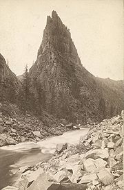
- CURECANTI CREEK
After descending from the high rim of the Upper Black Canyon of the Gunnison, the trail follows Curecanti Creek as it falls toward Morrow Point Reservoir. The Curecanti Needle
Curecanti Needle
The Curecanti Needle is a distinct granite rock formation near Curicante, Colorado. Rising approximately 215 m or 700 ft from the canyon floor, with its pointy shape and being situated on the shore of the former Gunnison River it is one of the landmarks of the Colorado Rocky Mountains.Until...
, a 700 ft (213.4 m). granite spire, towers above at the trail's end. Good shoes or boots are recommended. Carry at least 2 quarts of water per person. Two campsites with picnic tables, fire grates, and toilets are provided at the end of the trail.
Length: 4 miles (round trip)
Difficulty: Strenuous. Elevation change 900 ft (274.3 m). Allow 2–3 hours for round trip.
Directions: The trail head begins at the Pioneer Point overlook, off Highway 92, 5.7 miles (9.2 km) from its junction with Highway 50.
- HERMIT'S REST
Zigzagging through oak, pine, juniper, and fir, hikers descend to wooded camp and picnic sites on the shores of Morrow Point Reservoir. Campsites with picnic tables, fire grates, and toilets are provided at the end of the trail. Good shoes or boots are recommended. Carry at least 2 quarts of water per person. Check for ticks frequently during the hot summer months.
Length: 6 miles (round trip)
Difficulty: Very strenuous and little shade. Elevation change is 1800 ft (548.6 m). Allow 3 hours for round trip.
Directions: off Highway 92, 17 miles (27.4 km) west from its junction with Highway 50
- CRYSTAL CREEK
Winding through abundant wildflowers, Gambel oak, aspens, conifers and a recovering burn area, Crystal Creek Trail is ideal for spring or fall hiking. Sweeping views of Cimarron Valley, the West Elk and San Juan Mountains can be viewed along the way. The trail ends at an overlook, 1800 ft (548.6 m). above Crystal Reservoir. Good shoes or boots are recommended. Carry at least 2 quarts of water per person. Check for ticks frequently during the hot summer months.
Length: 5 miles (round trip)
Difficulty: Moderately strenuous. Trail begins at 8900 ft (2,712.7 m) above sea level. Allow 2 hours for round trip.
Directions: Off Highway 92, 24 miles (38.6 km) from its junction with Highway 50.
Other attractions
- The D & RG Narrow Gauge TrestleD & RG Narrow Gauge TrestleThe D & RG Narrow Gauge Trestle is a narrow gauge railroad trestle crossing of the Cimarron River, located near Cimarron, Colorado, United States...
(Denver & Rio Grande Western Narrow Gauge Trestle) is located in Cimarron CanyonCimarron River (Gunnison River watershed)The Cimarron River is a tributary that joins the Gunnison River in Curecanti National Recreation Area near Cimarron, Colorado. The river's source is the confluence of two forks near Silver Jack Reservoir in the Uncompahgre National Forest....
near Morrow Point Dam. It is the last remaining narrow gauge railroad trestleTrestleA trestle is a rigid frame used as a support, especially referring to a bridge composed of a number of short spans supported by such frames. In the context of trestle bridges, each supporting frame is generally referred to as a bent...
in the Black Canyon of the Gunnison. The trestle was built in 1895 by the Denver and Rio Grande Western RailroadDenver and Rio Grande Western RailroadThe Denver & Rio Grande Western Railroad , often shortened to Rio Grande or D&RGW, formerly the Denver & Rio Grande Railroad, is a defunct U.S. railroad company. The railroad started as a narrow gauge line running south from Denver, Colorado in 1870; however, served mainly as a transcontinental...
and was placed on the National Register of Historic PlacesNational Register of Historic PlacesThe National Register of Historic Places is the United States government's official list of districts, sites, buildings, structures, and objects deemed worthy of preservation...
in 1976.