
Cumbria Way
Encyclopedia
The Cumbria Way is a linear long distance footpath in Cumbria
, England
passing through the towns of Coniston
and Keswick
. It also passes through the Langdale and Borrowdale
valley
s. The majority of the route is inside the boundaries of the Lake District
National Park
.
This 112 km route through the heart of the Lake District National Park
links the two historic Cumbria
n towns of Ulverston
and Carlisle. The route cuts through classic Lakeland
country via Coniston
, Langdale, Borrowdale
, Derwent Water
, Skiddaw Forest and Caldbeck
. It is a primarily low-level long distance footpath but does contain some high-level exposed sections.
of the entire route was completed by volunteers and national park staff in May 2007.
of Ulverston
and ending in Carlisle .
 The route leaves the urban area of Ulverston
, birthplace of Stan Laurel
, and heads north towards the village of Gawthwaite and the boundary of the Lake District National Park
. The route, which consists primarily of field paths at this stage, then progresses towards the settlement of Sunny Bank and the shore of Coniston Water
. The western shoreline of Coniston Water
is followed before reaching the settlement of Coniston
.
Grizedale Forest
is visible to the east of the lake with Coniston Old Man and Dow Crag
being visible to the west on approach to Coniston
. This stage is approximately 24 km in length.
 The route leaves Coniston
heading in a NNW
direction through woodland
towards Tarn Hows
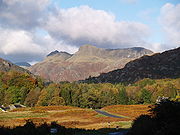
. The route involves some road walking as it passes through the villages of Colwith and Skelwith Bridge
. The Langdale Pikes soon become visible as the route leaves Skelwith Bridge
in a NNE
direction, passing Elter Water before entering the Great Langdale
valley
. This stage is approximately 17.5 km in length.
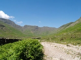
.jpg) The route leaves Langdale and travels alongside Mickleden beck. The mountain of Bow Fell passed to the west with the Langdale Pikes to the east. After a significant gain in elevation the route crosses Stake pass before descending via Langstrath beck and turning towards the villages of Stonethwaite
The route leaves Langdale and travels alongside Mickleden beck. The mountain of Bow Fell passed to the west with the Langdale Pikes to the east. After a significant gain in elevation the route crosses Stake pass before descending via Langstrath beck and turning towards the villages of Stonethwaite
and Rosthwaite
. The route subsequently follows the River Derwent
before reaching Derwent Water
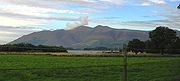
where it follows the shoreline path to reach the town of Keswick
. The mountains Skiddaw
and Blencathra
may be visible to the north. This stage is approximately 24 km in length.
 After some urban
walking on the exit from Keswick
, the route crosses the A591 road
before ascending past Latrigg
towards Skiddaw House (465m AMSL). After crossing the area of fell
s known as Back o'Skiddaw the route passes High Pike
and the Caldbeck Fells before descending towards the village of Caldbeck
. This stage is approximately 22.5 km in length.
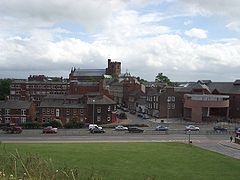 After leaving the village of Caldbeck
this final low-level section of the route follows the course of the River Caldew
to the largest Cumbria
n town of Carlisle. The route passes through the villages of Sebergham
, Buchaban and Dalston
following primarily woodland
and farmland
public footpaths and bridleways. This stage is approximately 24 km in length.
including vendace
, charr
, crayfish
and schelly
.
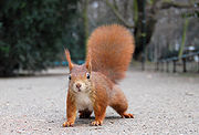
The red squirrel
can be found in woodland encountered on the route.
 The Ancient woodland
encountered throughout the route provide a favorable habitat, due to high precipitation
, for mosses, liverworts, fern
s and lichen
s. The boggy areas encountered, particularly during the high-level parts of the route, provide a habitat for carnivorous plants including sundew
and butterwort.
, Coast to Coast Walk
, Hadrian's wall path
, Cistercian Way, Eden Way and Windermere Way
.
maps
cover the route:
The following guidebook
s detail the route:
Cumbria
Cumbria , is a non-metropolitan county in North West England. The county and Cumbria County Council, its local authority, came into existence in 1974 after the passage of the Local Government Act 1972. Cumbria's largest settlement and county town is Carlisle. It consists of six districts, and in...
, England
England
England is a country that is part of the United Kingdom. It shares land borders with Scotland to the north and Wales to the west; the Irish Sea is to the north west, the Celtic Sea to the south west, with the North Sea to the east and the English Channel to the south separating it from continental...
passing through the towns of Coniston
Coniston, Cumbria
Coniston is a village and civil parish in the Furness region of Cumbria, England. It is located in the southern part of the Lake District National Park, between Coniston Water, the third longest lake in the Lake District, and Coniston Old Man; about north east of Barrow-in-Furness.-Geography and...
and Keswick
Keswick, Cumbria
Keswick is a market town and civil parish within the Borough of Allerdale in Cumbria, England. It had a population of 4,984, according to the 2001 census, and is situated just north of Derwent Water, and a short distance from Bassenthwaite Lake, both in the Lake District National Park...
. It also passes through the Langdale and Borrowdale
Borrowdale
Borrowdale is a valley and civil parish in the English Lake District in the Borough of Allerdale in Cumbria, England.Borrowdale lies within the historic county boundaries of Cumberland, and is sometimes referred to as Cumberland Borrowdale in order to distinguish it from another Borrowdale in the...
valley
Valley
In geology, a valley or dale is a depression with predominant extent in one direction. A very deep river valley may be called a canyon or gorge.The terms U-shaped and V-shaped are descriptive terms of geography to characterize the form of valleys...
s. The majority of the route is inside the boundaries of the Lake District
Lake District
The Lake District, also commonly known as The Lakes or Lakeland, is a mountainous region in North West England. A popular holiday destination, it is famous not only for its lakes and its mountains but also for its associations with the early 19th century poetry and writings of William Wordsworth...
National Park
National park
A national park is a reserve of natural, semi-natural, or developed land that a sovereign state declares or owns. Although individual nations designate their own national parks differently A national park is a reserve of natural, semi-natural, or developed land that a sovereign state declares or...
.
This 112 km route through the heart of the Lake District National Park
Lake District
The Lake District, also commonly known as The Lakes or Lakeland, is a mountainous region in North West England. A popular holiday destination, it is famous not only for its lakes and its mountains but also for its associations with the early 19th century poetry and writings of William Wordsworth...
links the two historic Cumbria
Cumbria
Cumbria , is a non-metropolitan county in North West England. The county and Cumbria County Council, its local authority, came into existence in 1974 after the passage of the Local Government Act 1972. Cumbria's largest settlement and county town is Carlisle. It consists of six districts, and in...
n towns of Ulverston
Ulverston
Ulverston is a market town and civil parish in the South Lakeland district of Cumbria in north-west England. Historically part of Lancashire, the town is located in the Furness area, close to the Lake District, and just north of Morecambe Bay....
and Carlisle. The route cuts through classic Lakeland
Lake District
The Lake District, also commonly known as The Lakes or Lakeland, is a mountainous region in North West England. A popular holiday destination, it is famous not only for its lakes and its mountains but also for its associations with the early 19th century poetry and writings of William Wordsworth...
country via Coniston
Coniston, Cumbria
Coniston is a village and civil parish in the Furness region of Cumbria, England. It is located in the southern part of the Lake District National Park, between Coniston Water, the third longest lake in the Lake District, and Coniston Old Man; about north east of Barrow-in-Furness.-Geography and...
, Langdale, Borrowdale
Borrowdale
Borrowdale is a valley and civil parish in the English Lake District in the Borough of Allerdale in Cumbria, England.Borrowdale lies within the historic county boundaries of Cumberland, and is sometimes referred to as Cumberland Borrowdale in order to distinguish it from another Borrowdale in the...
, Derwent Water
Derwent Water
Derwentwater is one of the principal bodies of water in the Lake District National Park in north west England. It lies wholly within the Borough of Allerdale, in the county of Cumbria....
, Skiddaw Forest and Caldbeck
Caldbeck
Caldbeck is a village and civil parish in the Borough of Allerdale, Cumbria, England. Historically within Cumberland, the village had 714 inhabitants according to the census of 2001. It lies on the northern edge of the Lake District. The nearest town is Wigton, 6 miles north east of the village...
. It is a primarily low-level long distance footpath but does contain some high-level exposed sections.
History
The Cumbria Way was originally devised in the 1970s by local Ramblers' Association members. The waymarkingWaymarking
Waymarking is an activity where people locate and log interesting locations around the world, usually with a GPS receiver and a digital camera. Waymarking differs from geocaching in that there is no physical container to locate at the given coordinates. Waymarking identifies points of interest for...
of the entire route was completed by volunteers and national park staff in May 2007.
Route
The route can be walked in either direction but is described here as south to north beginning at the trailheadTrailhead
A trailhead is the point at which a trail begins, where the trail is often intended for hiking, biking, horseback riding, or off-road vehicles...
of Ulverston
Ulverston
Ulverston is a market town and civil parish in the South Lakeland district of Cumbria in north-west England. Historically part of Lancashire, the town is located in the Furness area, close to the Lake District, and just north of Morecambe Bay....
and ending in Carlisle .
Stage 1: Ulverston to Coniston
Ulverston
Ulverston is a market town and civil parish in the South Lakeland district of Cumbria in north-west England. Historically part of Lancashire, the town is located in the Furness area, close to the Lake District, and just north of Morecambe Bay....
, birthplace of Stan Laurel
Stan Laurel
Arthur Stanley "Stan" Jefferson , better known as Stan Laurel, was an English comic actor, writer and film director, famous as the first half of the comedy team Laurel and Hardy. His film acting career stretched between 1917 and 1951 and included a starring role in the Academy Award winning film...
, and heads north towards the village of Gawthwaite and the boundary of the Lake District National Park
Lake District
The Lake District, also commonly known as The Lakes or Lakeland, is a mountainous region in North West England. A popular holiday destination, it is famous not only for its lakes and its mountains but also for its associations with the early 19th century poetry and writings of William Wordsworth...
. The route, which consists primarily of field paths at this stage, then progresses towards the settlement of Sunny Bank and the shore of Coniston Water
Coniston Water
Coniston Water in Cumbria, England is the third largest lake in the English Lake District. It is five miles long, half a mile wide, has a maximum depth of 184 feet , and covers an area of . The lake has an elevation of 143 feet above sea level...
. The western shoreline of Coniston Water
Coniston Water
Coniston Water in Cumbria, England is the third largest lake in the English Lake District. It is five miles long, half a mile wide, has a maximum depth of 184 feet , and covers an area of . The lake has an elevation of 143 feet above sea level...
is followed before reaching the settlement of Coniston
Coniston, Cumbria
Coniston is a village and civil parish in the Furness region of Cumbria, England. It is located in the southern part of the Lake District National Park, between Coniston Water, the third longest lake in the Lake District, and Coniston Old Man; about north east of Barrow-in-Furness.-Geography and...
.
Grizedale Forest
Grizedale Forest
Grizedale Forest is a 24.47 km² area of woodland in the Lake District of North West England, located to the east of Coniston Water and to the south of Hawkshead. It comprises a number of hills, small tarns and the settlements of Grizedale and Satterthwaite...
is visible to the east of the lake with Coniston Old Man and Dow Crag
Dow Crag
Dow Crag is a fell in the English Lake District near Coniston, Cumbria. The eastern face is one of the many rock faces in the Lake District used for rock climbing....
being visible to the west on approach to Coniston
Coniston, Cumbria
Coniston is a village and civil parish in the Furness region of Cumbria, England. It is located in the southern part of the Lake District National Park, between Coniston Water, the third longest lake in the Lake District, and Coniston Old Man; about north east of Barrow-in-Furness.-Geography and...
. This stage is approximately 24 km in length.
Stage 2: Coniston to Langdale
Coniston, Cumbria
Coniston is a village and civil parish in the Furness region of Cumbria, England. It is located in the southern part of the Lake District National Park, between Coniston Water, the third longest lake in the Lake District, and Coniston Old Man; about north east of Barrow-in-Furness.-Geography and...
heading in a NNW
NNW
NNW may refer to:*National Nurses Week, the week of May 6 through May 12 proclaimed by Richard Nixon in 1974 as a period for Americans to recognize nurses' service and contributions...
direction through woodland
Woodland
Ecologically, a woodland is a low-density forest forming open habitats with plenty of sunlight and limited shade. Woodlands may support an understory of shrubs and herbaceous plants including grasses. Woodland may form a transition to shrubland under drier conditions or during early stages of...
towards Tarn Hows
Tarn Hows
Tarn Hows is an area of the Lake District National Park, containing a picturesque tarn, approximately northeast of Coniston and about northwest of Hawkshead...
. The route involves some road walking as it passes through the villages of Colwith and Skelwith Bridge
Skelwith Bridge
Skelwith Bridge is a small village in the southern area of the Lake District in Cumbria, North West England. It is located around 3 miles south of Grasmere and is nearby the waterfalls of Skelwith Force and Colwith Force. The nearest lakes to the village are Elter Water to the north-west and...
. The Langdale Pikes soon become visible as the route leaves Skelwith Bridge
Skelwith Bridge
Skelwith Bridge is a small village in the southern area of the Lake District in Cumbria, North West England. It is located around 3 miles south of Grasmere and is nearby the waterfalls of Skelwith Force and Colwith Force. The nearest lakes to the village are Elter Water to the north-west and...
in a NNE
NNE
As an abbreviation, NNE may stand for:*Non-viable National Economy*North-northeast*Novo Nordisk Engineering...
direction, passing Elter Water before entering the Great Langdale
Great Langdale
Great Langdale is a valley in the Lake District National Park in the county of Cumbria, in the northwest of England. It is often simply referred to as Langdale, the epithet Great distinguishing it from the neighbouring valley of Little Langdale....
valley
Valley
In geology, a valley or dale is a depression with predominant extent in one direction. A very deep river valley may be called a canyon or gorge.The terms U-shaped and V-shaped are descriptive terms of geography to characterize the form of valleys...
. This stage is approximately 17.5 km in length.
Stage 3: Langdale to Keswick
Stonethwaite
Stonethwaite is a small village in the Lake District in the English county of Cumbria. It is situated in the valley of the Stonethwaite Beck, a side valley of Borrowdale, and within the Lake District National Park...
and Rosthwaite
Rosthwaite, Borrowdale, Cumbria
Rosthwaite is a settlement in Borrowdale in the English Lake District. It lies on the B5289 road to the south of Derwent Water and to the east of the Honister Pass in the county of Cumbria....
. The route subsequently follows the River Derwent
River Derwent, Cumbria
The Derwent is a river in the Lake District of the county of Cumbria in the north of England. The name Derwent is derived from a Celtic word for "oak trees"....
before reaching Derwent Water
Derwent Water
Derwentwater is one of the principal bodies of water in the Lake District National Park in north west England. It lies wholly within the Borough of Allerdale, in the county of Cumbria....
where it follows the shoreline path to reach the town of Keswick
Keswick, Cumbria
Keswick is a market town and civil parish within the Borough of Allerdale in Cumbria, England. It had a population of 4,984, according to the 2001 census, and is situated just north of Derwent Water, and a short distance from Bassenthwaite Lake, both in the Lake District National Park...
. The mountains Skiddaw
Skiddaw
Skiddaw is a mountain in the Lake District National Park in England. With a summit at 931 m above sea level it is the fourth highest mountain in England. It lies just north of the town of Keswick, Cumbria, and dominates the skyline in this part of the northern lakes...
and Blencathra
Blencathra
Blencathra, also known as Saddleback, is one of the most northerly mountains in the English Lake District. It has six separate fell tops, of which the highest is the Hallsfell Top.-Name:...
may be visible to the north. This stage is approximately 24 km in length.
Stage 4: Keswick to Caldbeck
Urban area
An urban area is characterized by higher population density and vast human features in comparison to areas surrounding it. Urban areas may be cities, towns or conurbations, but the term is not commonly extended to rural settlements such as villages and hamlets.Urban areas are created and further...
walking on the exit from Keswick
Keswick, Cumbria
Keswick is a market town and civil parish within the Borough of Allerdale in Cumbria, England. It had a population of 4,984, according to the 2001 census, and is situated just north of Derwent Water, and a short distance from Bassenthwaite Lake, both in the Lake District National Park...
, the route crosses the A591 road
A591 road
The A591 is a major road in Cumbria, in the north-west of England. The stretch of the road between Windermere and Keswick has been voted Britain's Favourite Road.-Route:...
before ascending past Latrigg
Latrigg
Latrigg is one of the lowest fells in the Lake District, but is a popular climb due to its convenient location overlooking the town of Keswick and the beautiful views down the valley of Borrowdale from the summit. It is the least mountainous of the Skiddaw fells, the summit being almost entirely...
towards Skiddaw House (465m AMSL). After crossing the area of fell
Fell
“Fell” is a word used to refer to mountains, or certain types of mountainous landscape, in Scandinavia, the Isle of Man, and parts of northern England.- Etymology :...
s known as Back o'Skiddaw the route passes High Pike
High Pike (Caldbeck)
High Pike is a fell in the northern part of the English Lake District, it is located 4.5 kilometres south of Caldbeck. It has a height of 658 metres and is the most northerly of the Lakeland fells over 2000 feet. It is a large fell with its northern slopes falling away towards the lower ground...
and the Caldbeck Fells before descending towards the village of Caldbeck
Caldbeck
Caldbeck is a village and civil parish in the Borough of Allerdale, Cumbria, England. Historically within Cumberland, the village had 714 inhabitants according to the census of 2001. It lies on the northern edge of the Lake District. The nearest town is Wigton, 6 miles north east of the village...
. This stage is approximately 22.5 km in length.
Stage 5: Caldbeck to Carlisle
Caldbeck
Caldbeck is a village and civil parish in the Borough of Allerdale, Cumbria, England. Historically within Cumberland, the village had 714 inhabitants according to the census of 2001. It lies on the northern edge of the Lake District. The nearest town is Wigton, 6 miles north east of the village...
this final low-level section of the route follows the course of the River Caldew
River Caldew
The River Caldew is a river running through Cumbria in England. Historically, the county watered by the Caldew was Cumberland.The Caldew's source is high up on Skiddaw, between the summit and Sale How, in the Lake District, from where it runs east through a valley between Bowscale Fell and Carrock...
to the largest Cumbria
Cumbria
Cumbria , is a non-metropolitan county in North West England. The county and Cumbria County Council, its local authority, came into existence in 1974 after the passage of the Local Government Act 1972. Cumbria's largest settlement and county town is Carlisle. It consists of six districts, and in...
n town of Carlisle. The route passes through the villages of Sebergham
Sebergham
Sebergham is a small village and civil parish in the English county of Cumbria. It is located on the B5305, south of Carlisle and south-east of Wigton....
, Buchaban and Dalston
Dalston, Cumbria
Dalston is a large village and civil parish within the City of Carlisle district of Cumbria, England. It is situated on the B5299 road about four miles south-south-west of Carlisle city centre, and approximately five miles from Junction 42 of the M6 motorway.The village has a population of around...
following primarily woodland
Woodland
Ecologically, a woodland is a low-density forest forming open habitats with plenty of sunlight and limited shade. Woodlands may support an understory of shrubs and herbaceous plants including grasses. Woodland may form a transition to shrubland under drier conditions or during early stages of...
and farmland
Arable land
In geography and agriculture, arable land is land that can be used for growing crops. It includes all land under temporary crops , temporary meadows for mowing or pasture, land under market and kitchen gardens and land temporarily fallow...
public footpaths and bridleways. This stage is approximately 24 km in length.
Flora and Fauna
The tarns encountered on the route provide a habitat for a wide range of speciesSpecies
In biology, a species is one of the basic units of biological classification and a taxonomic rank. A species is often defined as a group of organisms capable of interbreeding and producing fertile offspring. While in many cases this definition is adequate, more precise or differing measures are...
including vendace
Vendace
Vendace can refers to several species of fish, but especially these species of freshwater whitefish:*Coregonus albula, widespread in northern continental Europe...
, charr
Salvelinus
Salvelinus is a genus of salmonid fish often called char or charr; some species are called "trout". Salvelinus is a member of the Salmoninae subfamily of the Salmonidae family. Charr may be identified by light cream pink or red spots over a darker body. Scales tend to be small, with 115-200 along...
, crayfish
Crayfish
Crayfish, crawfish, or crawdads – members of the superfamilies Astacoidea and Parastacoidea – are freshwater crustaceans resembling small lobsters, to which they are related...
and schelly
Schelly
The schelly is a designation for four populations of freshwater whitefish in the English Lake District, Cumbria. The native populations of this fish inhabit the Brothers Water, Haweswater, Red Tarn and Ullswater, and occupy a total area of about 20 square kilometers...
.
The red squirrel
Red Squirrel
The red squirrel or Eurasian red squirrel is a species of tree squirrel in the genus Sciurus common throughout Eurasia...
can be found in woodland encountered on the route.
Ancient woodland
Ancient woodland is a term used in the United Kingdom to refer specifically to woodland that has existed continuously since 1600 or before in England and Wales . Before those dates, planting of new woodland was uncommon, so a wood present in 1600 was likely to have developed naturally...
encountered throughout the route provide a favorable habitat, due to high precipitation
Precipitation (meteorology)
In meteorology, precipitation In meteorology, precipitation In meteorology, precipitation (also known as one of the classes of hydrometeors, which are atmospheric water phenomena is any product of the condensation of atmospheric water vapor that falls under gravity. The main forms of precipitation...
, for mosses, liverworts, fern
Fern
A fern is any one of a group of about 12,000 species of plants belonging to the botanical group known as Pteridophyta. Unlike mosses, they have xylem and phloem . They have stems, leaves, and roots like other vascular plants...
s and lichen
Lichen
Lichens are composite organisms consisting of a symbiotic organism composed of a fungus with a photosynthetic partner , usually either a green alga or cyanobacterium...
s. The boggy areas encountered, particularly during the high-level parts of the route, provide a habitat for carnivorous plants including sundew
Sundew
Drosera, commonly known as the sundews, comprise one of the largest genera of carnivorous plants, with at least 194 species. These members of the family Droseraceae lure, capture, and digest insects using stalked mucilaginous glands covering their leaf surface. The insects are used to supplement...
and butterwort.
Connecting trails
The route connects with the Allerdale Ramble, Cumbria Coastal WayCumbria Coastal Way
The Cumbria Coastal Way is a long distance footpath allowing users to travel from Cumbria's southern border to just north of the English - Scottish border. It follows some interesting scenery such as the red sandstone cliffs of St...
, Coast to Coast Walk
Coast to Coast Walk
The Coast to Coast Walk is a 192-mile unofficial and mostly unsignposted long distance footpath in Northern England...
, Hadrian's wall path
Hadrian's Wall Path
The Hadrian’s Wall Path is a long distance footpath in the north of England, which became the 15th National Trail in 2003. It runs for , from Wallsend on the east coast of Great Britain to Bowness-on-Solway on the west coast. The path runs through urban areas, and over moors...
, Cistercian Way, Eden Way and Windermere Way
Windermere Way
The Windermere Way is a 45 mile circuit of Windermere, a lake in the English Lake District. The route is wholly within the Lake District National Park and takes in the summits of Wansfell, Loughrigg Fell and Gummer's How as well as passing through the towns of Ambleside and Windermere.-History and...
.
Further reading
The following Ordnance SurveyOrdnance Survey
Ordnance Survey , an executive agency and non-ministerial government department of the Government of the United Kingdom, is the national mapping agency for Great Britain, producing maps of Great Britain , and one of the world's largest producers of maps.The name reflects its creation together with...
maps
MAPS
Maps is the plural of map, a visual representation of an area.As an acronym, MAPS may refer to:* Mail Abuse Prevention System, an organisation that provides anti-spam support...
cover the route:
- Explorer 1:25k sheets OL4, OL5, OL6, OL7 and 315
- Landranger 1:50k sheets 85, 90 and 97
The following guidebook
GUIdebook
GUIdebook is a website that contains screenshots of computer software.It shows a visual history of the software's user interface. It includes operating systems like Mac OS and Windows, desktop environments like GNOME and KDE, portable operating systems like Newton OS and Windows CE, and...
s detail the route:
- The Cumbria Way and the Allerdale Ramble, Jim Watson, Cicerone Press, ISBN 9781852842420
- The Cumbria Way, Anthony Burton, ISBN 1854106155. Aurum Press.
- The Cumbria Way, John Trevelyan, ISBN 1855681978. Dalesman